|

Understanding through Discussion |
|
|
Register | Sign In |
|
QuickSearch
| Thread ▼ Details |
|
Thread Info
|
|
|
| Author | Topic: The TRVE history of the Flood... | |||||||||||||||||||||||||||||||||||||||||||||||
|
edge Member (Idle past 1736 days)  Posts: 4696 From: Colorado, USA Joined:
|
The first thing you would need to know to make such a conclusion is how much water are you talking about.
You know, there is nothing in this entire post that comes close to answering my question of where the water receded to. What was the land elevation at the time of the Biblical Flood?Was there any mountains, if so how high were they? The Hebrew word translated mountains means a rise in land mass and is translated by our translators as hills, high hill, and mountains at their discretion. Based upon what they know the earth to look like in the days they were living. Since you are looking at the earth in the shape it is in today you assume it has always been like it is today. The Imago Mundi from Babylonia, 500 BCE. Is a map that shows a land mass surrounded by water and 7 islands. Showing the islands means they had water transportation and could navigate to these islands. This map has a cuneiform inscription that makes it a copy of an earlier map of the region. So it was a handed down map of an earlier earth. This particular map is over 2500 years old and in existence today. So we have no way of knowing what the earth was like before the flood. We can only make assumptions. We do know what it looks like today because we have satellite's that can take pictures of it. There is sea shells on the top of the mountain ranges which prove that at one time those mountains were covered with water before they were pushed up into mountains. Genesis 1:2 tells us the land mass of the earth was covered with water. This is required for the sea shells to be on mountain tops. Genesis 1:9 tells us all water was gathered into one place and dry land appeared. (I get the same picture from that description as the Babylonian Map of the World known as the Imago Mundi.).This is required for Pangea to exist as science claims. So if we could ever determine the sea level of the land mass that existed at the time of the flood we could determine how much water we had to get rid of. Taking into consideration that The Bay of Fundy waters rise 55' and fall 55' every 11+ hours we have an example of how God can move water around to suite His will. It doesn't seem unreasonable to me for God to remove the amount of water needed to cause the dry land to appear as He had already done so in Genesis 1:9. Besides we do have some ideas on what the earth looked like in the past. Do you want to discuss that? ETA: Face it. This would be the biggest geological event in the history of the earth and yet we don't see anything other than normal processes going back into geological history. Edited by edge, : No reason given.
|
|||||||||||||||||||||||||||||||||||||||||||||||
|
edge Member (Idle past 1736 days) Posts: 4696 From: Colorado, USA Joined:
|
And angular unconformities are the ONLY supposed evidence for deposition following tectonic disturbance ...
Not really. The are, however, the most notable and spectacular. Other indicators would be overthrust faults, growth faults, molasse deposits, foreland basins, intermontane basins, alluvial fans, etc., etc. How many do you want?
... and they are usually pretty pathetic looking broken horizontal pieces perched on top of some buckled strata.
What do you mean by "broken horizontal pieces"? And why is that pathetic?
Which indicates that whatever caused the tectonic disturbance knocked off all the strata above the pathetic piece.
Well, yes, erosion 'knocked off" some of the exposed parts of the folded rocks. The only 'pathetic piece' around here seems to be your argument against the geological record of the planet.
|
|||||||||||||||||||||||||||||||||||||||||||||||
|
edge Member (Idle past 1736 days) Posts: 4696 From: Colorado, USA Joined: |
OK, yes, EXCEPT for the Great Unconformity. All the strata above that point were in place before the tectonic disturbance that followed.
.. at the Grand Canyon.
|
|||||||||||||||||||||||||||||||||||||||||||||||
|
edge Member (Idle past 1736 days) Posts: 4696 From: Colorado, USA Joined:
|
The water came from the sky and from the fountains of the deep.
In your story, yes.
As far as the biggest geological event in the history of the earth. Why don't you take a trip to the Bay of Fundy and watch the tide come in and go out.
I have. What does that have to do with anything?
If you don't want to take the trip and see it in person you can visit it online. You will notice that even though the water rises and falls 55 feet in 11+ hours it does very little damage.
Of course not, it's a normal every day event. It's not a tsunami.
|
|||||||||||||||||||||||||||||||||||||||||||||||
|
edge Member (Idle past 1736 days) Posts: 4696 From: Colorado, USA Joined:
|
Are you that nave?
Naivete is not one of my strong points.
Any hole in the earth is a fountain whether it spews out cold water, hot water, or molten rock.
As you wish. However, I don't see any of these things producing a flood.
According to whom? The Bible says no such thing.
Okay, so that's your story.
It only says the water rose and covered the earth. You been reading AIG's fairy tale books that Faith reads. Or some of the Seventh Day Adventist teachings about the flood.
Well, reading YEC stories does get confusing.
You sure have not been reading what the Bible says. No wonder you are so mixed up about the Biblical record of the flood.
Thank you.
What evidence do you have that the water coming out of the fountains of the deep would do any damage. The Bible does not say anything about the volcanos erupting only the water rising.
Hey, I can only know what you guys tell me about a fanciful event.
The water in the Bay of Fundy rises 55 feet and falls 55 feet every Eleven plus hours and does very little damage.
Most tsunamis are less than that and do a lot of damage.
The fountains of the deep are not little small cracks in the rocks, and it would take more than limestone to hold the water pressure the water under the ground at the bottom of the sea is under. Any liquid be it water or oil is under a lot of pressure
That's not the point. But since I don't really care, I can't remember why I mentioned that.
We have a lot of fountains of the deep in Florida. Silver Springs, at Ocala, Wakula Springs at Wakula and Homosassa Springs, at Homosassa which produces all the drinking water for St Petersburg. Then we have Blue springs, White springs just to name a few. These put out thousands of gallons per hour 24/7. They do no damage. We have wells that produce water the say way except a pipe has been drilled down to where the water is. Although most of those are capped or have a shutoff valve on them now.
That's nice. But not really relevant. None of them would flood the earth. And I have been to some of them. Do you understand where the water coming from these springs comes from?
But if you want to discuss flood ideas with me you going to have to leave Faith's musings behind.
Few things would give me more pleasure. I think...
Faith and I agree on one thing and that a world wide flood happened not to far in the past.
Well, in that case, you are both wrong. There is no evidence to suggest that such a thing happened. Edited by edge, : No reason given.
|
|||||||||||||||||||||||||||||||||||||||||||||||
|
edge Member (Idle past 1736 days) Posts: 4696 From: Colorado, USA Joined: |
You DO mean the tilted strata to the north of the fault? How could it not happen afterward if the vertical mile drop happened afterward? And again edge said a long time ago that the tilting is something that faults do, they drag the strata like that.
Not to terminate the discussion or anything, but before going any further here, it should be noted that the Hurrican Fault IS the limit of the Colorado Plateau. The other side of the fault is considered to be the Basin and Range Province which has undergone a very different geological history than the Colorado Plateau. The fact that we see various forms of deformation at the edge of the CP probably isn't of importance here except to point out that there were things going on in other regions. I wouldn't be concerned about seeing some folding due to earlier deformation at the edge of the CP. However, there almost certainly is some deformation of the Claron adjacent to the Hurricane Fault. I'm not sure if it shows in the large cross section, but I'm pretty certain that the edge of the Claron near the fault is down-warped due to drag along the fault. I can't find much on the Claron itself, but other formations do show this. It is a local effect. Any tilting toward the CP (the other direction) is likely due to earlier tectonic edge effects. This could get pretty technical.
|
|||||||||||||||||||||||||||||||||||||||||||||||
|
edge Member (Idle past 1736 days) Posts: 4696 From: Colorado, USA Joined:
|
That's very informative, seeing it as the end of the Colorado Plateau in particular which fits it into my scenario too, whereas before I didn't have a picture of how and when the plateau had formed. Also interesting the idea that the Claron was probably deformed adjacent to the fault, although since the strata beneath it are upwarped I don't know why the edge of the Claron would be downwarped.
As I said, it is a local feature that is shared by other formations beneath. As to the regional tilt to the east, I tried to treat that with the observation that there were things going on in the Great Basin area that caused this regional arch. We could get into it, but the discussion can get pretty deep, and really, it doesn't mean much to the overall discussion here. The takeaway is that the Colorado Plateau, even though it is not as you describe it, tells us very little about what is going on in the rest of the world. To focus on this one region is misleading.
|
|||||||||||||||||||||||||||||||||||||||||||||||
|
edge Member (Idle past 1736 days) Posts: 4696 From: Colorado, USA Joined:
|
The mental masturbation you go through to shoehorn a myth is entertaining, but to turn it around and accuse others of doing it, is dishonest and shameful.
This is a dire example of what religion can do to a brain. Fortunately, it's all pretty harmless. For now.
|
|||||||||||||||||||||||||||||||||||||||||||||||
|
edge Member (Idle past 1736 days) Posts: 4696 From: Colorado, USA Joined: |
I had described the upper strata as mounding OVER the Supergroup. "Dipping" is not a term I'd use for it. The point of the mounding is that it demonstrates the pushing up of the upper strata from beneath, since the strata would not follow the contour of the mound if they were laid down afterward. There is really no other reasonable explanation.
Actually, there are a couple of other possibilities, however, it's kind of irrelevant particularly since that contact is probably based on a very limited amount of data. The most likely explanation is that the surface is actually more irregular than depicted and since the surface is an erosional unconformity, the best explanation is that this is just a regional slope toward a sea to the west. I wouldn't read to much into the 'hump'. On the other hand the boundaries of the GC Supergroup are kind of important in the history of the canyon area.
|
|||||||||||||||||||||||||||||||||||||||||||||||
|
edge Member (Idle past 1736 days) Posts: 4696 From: Colorado, USA Joined:
|
So how do you explain the quartzite boulder fifteen feet in diameter that was clearly broken off the Shinumo quartzite but is found embedded in the Tapeats sandstone a quarter of a mile from the Shinumo?
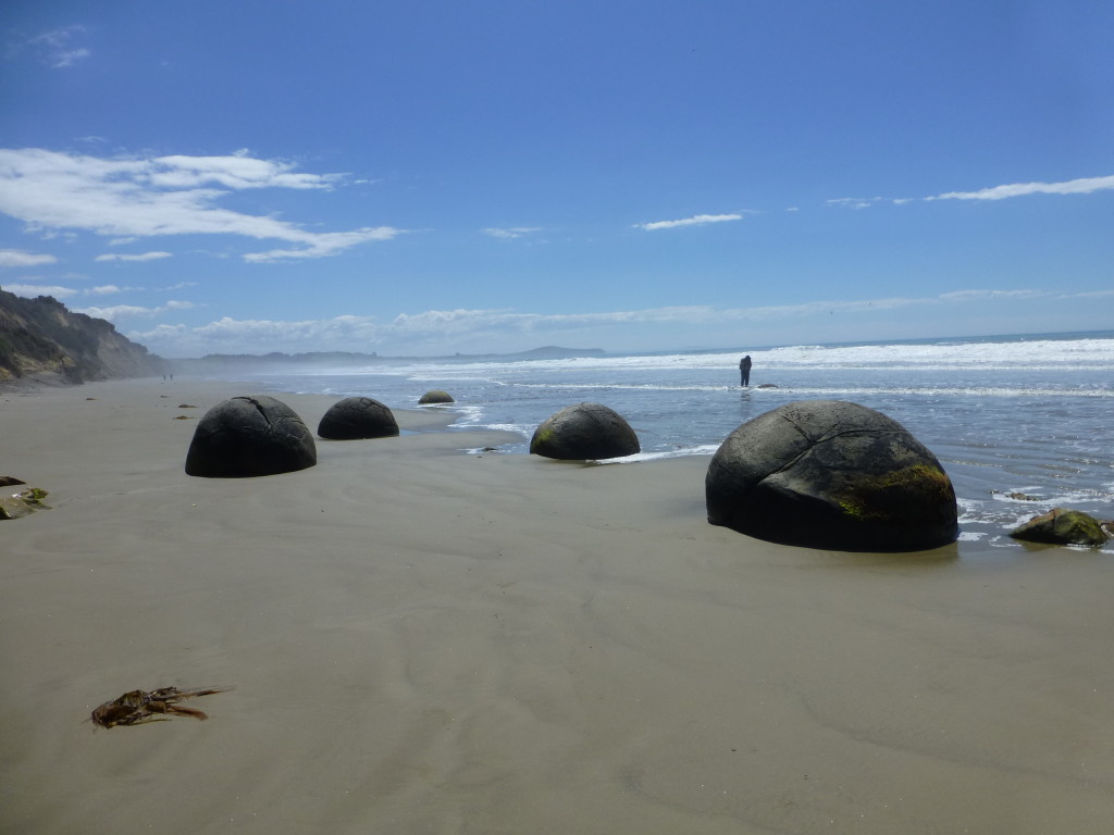
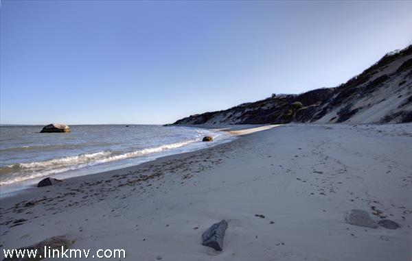
I don't have a problem with that at all. Along many seashores there are boulders with no obvious attachment to their sources. Here are some in New Zealand.
The point here is that we are dealing with an erosional surface and an encroaching sea. ETA: I am reposting some pictures of erratic boulders on beaches. The boulders above, it turns out are concretionary and do not make the point that I wanted. Most erratics like the Shinumo boulder are considered to be glacial in origin. Here is a glacial erratic in British Columbia:
It is obviously of exotic character in both size and composition to the surrounding sand and must have been transported. Then there are exotic boulders like these that don't have a definite explanation.
And then, of course, there are the drop stones that we talked about last year:
Edited by edge, : No reason given.
|
|||||||||||||||||||||||||||||||||||||||||||||||
|
edge Member (Idle past 1736 days) Posts: 4696 From: Colorado, USA Joined:
|
I hope you don't mind if I tell you that I laughed out loud at your picture of boulders on a beach in answer to my question. The cleverness involved is quite amusing.
I thought that might happen. However, we know that boulders can move down very gently slopes and there are a number of mechanisms, including some glacial effects.
Let me ask: Would you expect to find the source of any of those rocks in a sedimentary layer buried under that beach?
Possibly, but the fact that the rocks are rounded suggests that they have been transported. ETA: I have to correct this. These particular rocks are rounded because they are concretions. Most such erratic rocks are not so well-rounded, but are enough to say that they are obviously transported.
Do blocks of strata normally underlie beaches?
If you go deep enough, yes.
How would you account for the separation of the rock from its source?
Gravity acting on a slope.
Do you expect that beach someday to be like the Tapeats layer in the GC?
If it doesn't get eroded away before then.
So, the GC was formed by intermittent risings of water over the land depositing this or that, some six of them altogether? So I suppose the land had to sink to the necessary level for each new shallow sea to cover it without being deep enough to associate it with Noah's Flood?
Actually, the Grand Canyon was formed by erosion.
So it keeps sinking for each new sea transgression until it gets all the layers laid down, and then what? Then we get the pushing up of the Colorado plateau because of course those miles of layers aren't going to stay below sea level?
The origin of the Colorado Plateau is getting more technical as we study it. This post was about isolated boulders in a sandstone. Edited by edge, : No reason given.
|
|||||||||||||||||||||||||||||||||||||||||||||||
|
edge Member (Idle past 1736 days) Posts: 4696 From: Colorado, USA Joined: |
How do strata form "by erosion?"
As I said, canyons are formed by erosion.
|
|||||||||||||||||||||||||||||||||||||||||||||||
|
edge Member (Idle past 1736 days) Posts: 4696 From: Colorado, USA Joined: |
I find it hard to consider the quartzite boulder as having occurred by the same processes that produced the boulders you have illustrated.
Why not? Do you think the Shinumo boulder was never at the surface like the ones I've shown?
It is embedded IN the Tapeats sandstone a small space above the Great Unconformity a quarter mile from the Shinumo layer, in such a way as to suggest it was broken off that layer and carried that distance by the forces I keep describing.
I'm not sure what forces you mean. But yes, the boulder is buried in the Tapeats just like any fossil or any other pebble. I'm not sure what your problem is here.
|
|||||||||||||||||||||||||||||||||||||||||||||||
|
edge Member (Idle past 1736 days) Posts: 4696 From: Colorado, USA Joined:
|
They were eroded by the movement between the strata and the tilted group. The strata were all in place, the lower strata were tilted by tectonic force, raising the whole stack above, shown by the curving of the stack over the Supergroup, showing that it was all pushed up by the tectonic force, the fault lines were cut off by the abrasion at the contact etc.
Faith, what is your evidence for this "abrasion at the contact"? Please provide us some kind of data, such as a photograph, that shows textures caused by abrasion.
The vertical movement was abruptly halted by the horizontal movement at the GU contact, cutting off the fault and its step.
Ah, good. Then you can show us where these faults still exist above the unconformity. If they were 'cut off' in the manner you suggest, they should appear somewhere. Show us the offset.
The erosion and the movement of the boulder, ...
Please show us some kind of track for the boulder. What surfaces (such as a fault plane) formed during this translation. For instance, if I move my car, you can see the surface that it moved on. If one block of rock moved while in contact with another, there is a shear plane. Please show us your evidence.
... the cutting off of the fault and its step,
See above.
... the confinement of the magma -- granite, schist etc.
Again, if you are correct, we should be able to find some offset blocks of schist or granite above the unconformity someplace. That is what we would call 'evidence'.
The horizontal movement would easily accomplish all that and without it you'd probably have your step and the magma would have penetrated up into the strata.
Why would it be 'easy'? What array of forces would cause a detachment (and that IS what you are talking about) such that upper layer would not be in traction with the lower. What is the dynamic situation in the crust to result in such a scenario? Why is it that in known detachment faults (see: Lewis Thrust), the upper plate is the one that is deformed?
|
|||||||||||||||||||||||||||||||||||||||||||||||
|
edge Member (Idle past 1736 days) Posts: 4696 From: Colorado, USA Joined: |
You've somehow misunderstood my point: the faults were cut off so they are NOT above the unconformity.
So, you are saying that the fault occurred after all sediments. In that case it should have penetrated all of the layers, yes? And yet, here you say that it doesn't.
I don't think the boulder itself moved, I think the basement rocks moved horizontally in relation to the strata above.
So, then, the boulder is not separated from its source rock? That makes no sense. Did it just magically appear there?
Strange, you are asking for exactly what I said didn't happen for the reasons I gave. The movement confined the granite and schist beneath the GU, why are you saying "therefore" it should be found above it? That makes NO sense whatever.
So, the movement exactly followed the contact between the upper layers and the lower? And it meandered across the Shinumo hills and islands, bending exactly to the top of the Precambrian rocks? Sorry, that has never been observed on a regional scale. You have some evidence, I presume.
Sorry, NO idea what you are talking about. What "detachment" -- you mean the sliding between the levels?
That's exactly what you want to have happened. The upper layers were detached from the lower basement along a flat fault.
Tectonic pressure below against enormous weight above, separated at the point where the forces are most closely balanced.
That doesn't answer my questions. How did the forces act and what was the dynamic situation of the forces. In fact, you have avoided several of my questions from the previous post. Am I to assume that you have no answers?
|
|||||||||||||||||||||||||||||||||||||||||||||||
|
|
Do Nothing Button
Copyright 2001-2023 by EvC Forum, All Rights Reserved
![]() ™ Version 4.2
™ Version 4.2
Innovative software from Qwixotic © 2024

 (1)
(1)