|

Understanding through Discussion |
|
|
Register | Sign In |
|
QuickSearch
Summations Only | Thread ▼ Details |
|
Thread Info
|
|
|
| Author | Topic: Why the Flood Never Happened | ||||||||||||||||||||||||
|
RAZD Member (Idle past 1435 days)  Posts: 20714 From: the other end of the sidewalk Joined: |
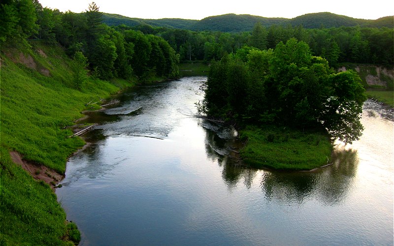
When I was a kid growing up in Ann Arbor they used to have tours of the salt mines. Don't know if they still do.
 by our ability to understand Rebel American Zen Deist ... to learn ... to think ... to live ... to laugh ... to share. Join the effort to solve medical problems, AIDS/HIV, Cancer and more with Team EvC! (click)
|
||||||||||||||||||||||||
|
RAZD Member (Idle past 1435 days) Posts: 20714 From: the other end of the sidewalk Joined: |
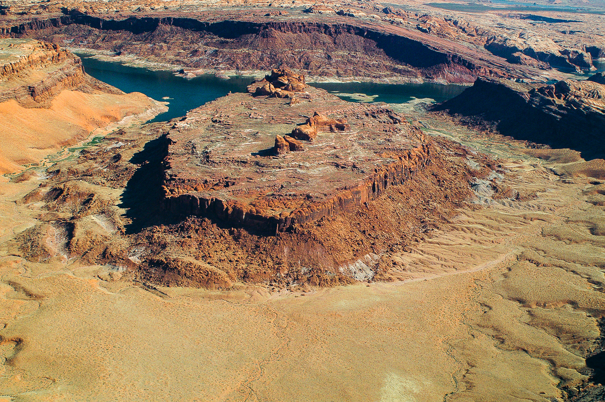
Leave us not forget the Goosenecks of the San Juan: Indeed, it seems to me that the best argument against a flood carved Grand Canyon is all the similar erosion of the canyons upstream of the Grand Canyon -- or the focus on the Grand Canyon is irrelevant if the upper canyons are not formed by the same process. by our ability to understand Rebel American Zen Deist ... to learn ... to think ... to live ... to laugh ... to share. Join the effort to solve medical problems, AIDS/HIV, Cancer and more with Team EvC! (click)
|
||||||||||||||||||||||||
|
RAZD Member (Idle past 1435 days) Posts: 20714 From: the other end of the sidewalk Joined: |
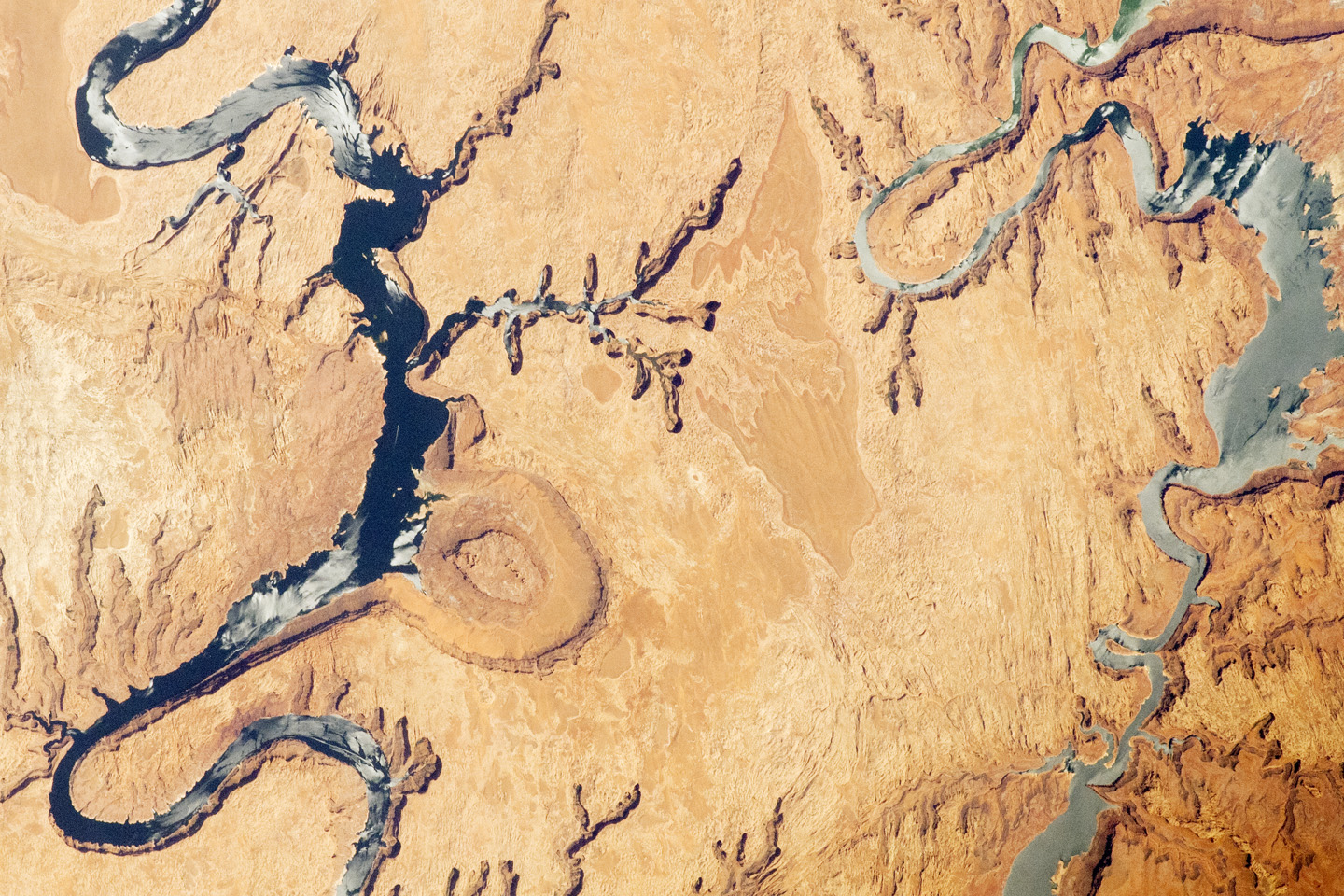
Here's an interesting image from a little further upstream on the Colorado but still within Lake Powell. It shows a meander that has been cutoff and is now a meander scar.
Beauty! Couldn't be better. That would have been a narrow section of a meander that eroded through, with slope failure where it was undercut from each side. This is what is impending in the picture I showed. Edited by RAZD, : all three images Edited by Admin, : Narrow image width.by our ability to understand Rebel American Zen Deist ... to learn ... to think ... to live ... to laugh ... to share. Join the effort to solve medical problems, AIDS/HIV, Cancer and more with Team EvC! (click)
|
||||||||||||||||||||||||
|
RAZD Member (Idle past 1435 days) Posts: 20714 From: the other end of the sidewalk Joined: |
Here's another one that has both the Rincon and the San Juan River meanders in one shot.
So how would flood flow cause that meander to form and then be cut through?by our ability to understand Rebel American Zen Deist ... to learn ... to think ... to live ... to laugh ... to share. Join the effort to solve medical problems, AIDS/HIV, Cancer and more with Team EvC! (click)
|
||||||||||||||||||||||||
|
RAZD Member (Idle past 1435 days) Posts: 20714 From: the other end of the sidewalk Joined: |
I would say that is deep. I found out more about the green color. It comes from an anaerobic environment where Fe(III) is reduced to Fe(II). So the requirement is not "deep", per say, but anaerobic. But 100 feet should do. And a lot of things can cause an anaerobic condition -- peat bogs for instance -- without being deep. To me the flood lake hypothesis is a non-starter because a draining lake does not form canyons like we see upstream of the GC, end of argument, the flow conditions are totally different for the drained lake area than for the outflow, and this fails to explain the similar formations between canyons above and below Page and the Powell Dam. by our ability to understand Rebel American Zen Deist ... to learn ... to think ... to live ... to laugh ... to share. Join the effort to solve medical problems, AIDS/HIV, Cancer and more with Team EvC! (click)
|
||||||||||||||||||||||||
|
RAZD Member (Idle past 1435 days) Posts: 20714 From: the other end of the sidewalk Joined: |
It didn't. The flood flow cut the wide part of the canyon and after that had pretty much drained away then river water running from the higher ground east of that part of the canyon cut the meanders and all the rest of it So now the flood to a side step into a dead end off the main river line, forming a box canyon perpendicular to the river flow line, another not seen fantasy ... And then the river cut through hundreds of feet of rock just because the box canyon was there rather than straight down the main flow line. And then it cut through the meander peninsula rock. In a few days. Riiiiiiiiiiiight. This is above the Grand Canyon Faith. Your scenario for formation of the Grand Canyon relies on this area being flooded, pooled, before it cuts through the ridge. Your path cutting flow is already past, so how do you cut these canyons? Move the lake upstream? by our ability to understand Rebel American Zen Deist ... to learn ... to think ... to live ... to laugh ... to share. Join the effort to solve medical problems, AIDS/HIV, Cancer and more with Team EvC! (click)
|
||||||||||||||||||||||||
|
RAZD Member (Idle past 1435 days) Posts: 20714 From: the other end of the sidewalk Joined: |
... except that if it narrows the river channel I'd expect it to increase the velocity of the river, and I'd expect the material eventually to be carried down the river I suppose ... But the arguments for how supposedly a river cuts deeper into an uplift still leave me unconvinced. ... Why would there be any difference in the increased velocity and erosion occurring from any constriction of the river flow? If uplift causes a small mounding in the river bottom and bank collapse causes a small mounding in the river bottom, how can the river know which is which? by our ability to understand Rebel American Zen Deist ... to learn ... to think ... to live ... to laugh ... to share. Join the effort to solve medical problems, AIDS/HIV, Cancer and more with Team EvC! (click)
|
||||||||||||||||||||||||
|
RAZD Member (Idle past 1435 days) Posts: 20714 From: the other end of the sidewalk Joined: |
I kept putting off responding to this post because I don't think I'm getting this explanation either. Let's see if we can find the trouble.
So far so good. A meandering path for the water prior to the uplift.
Right, but that's all the original description suggests, the idea that "uplift instigates headcutting," as if simple elevation had some power to require a river to cut more deeply. That's the way people here have said it and that's the way the geologist in the short video way back there now put it, and its being put that way is what keeps suggesting Wonderland to me. ... We'll assume that all those previous posts somehow missed this rather critical element, and that now we have cleared this up: uplift has a boundary, and that at this boundary is where we first find added erosion that leads to the headcutting.
At the WESTERN end. Which is the middle junction between the two boxes in this experiment.
... NOTHING has been said about the water's having to climb ONTO the uplift, ... It isn't -- the whole plain upstream is lifted for this part of the experiment. Thus we lift the upstream box maintaining the slope it had before that caused meanders. Whether we lift it 10" in one lift or 1" increments in 10 lifts the results should be similar: headcutting from the junction point uplift boundary upstream until either (1) the bottom slope matched the slope of the downstream box or (2) stopped at a steeper slope but one where erosion no longer occurred (not necessarily the same slope but they could be).
... but that's what HBD has been picturing, the idea being that somehow or other this increases the river's velocity and therefore its erosive power which is HOW it cuts deeper. Now, IF it actually does that. then I can see that it would have greater erosive power, but I still have this nagging feeling there's no way that can happen in this universe. ... but again my head is spinning down the rabbit hole at the thought of water having to CLIMB an uplift in the first place in spite of HBD's attempt to demonstrate how it supposedly works. This is the other part of uplift when the ridge at the eastern end of the canyon is lifted, so let's keep these two parts separate at this point. We'll come back to this part later.
Now you go on to say that GRADUAL uplift is somehow the key here, I guess so that the erosion can stay even with the uplift, ... Yes, the key is thinking of a slow continuous process that occurs while the river is flowing.
At this point we have demonstrated the formation of meanders, yes? Yes. Good.
I am unable to picture where this uplift occurs in relation to the meanders. The whole upstream box is lifted, with all the meanders that have happened on that section, the whole downstream box is unmoved, with all the meanders that have happened on that section. The only difference is the change in elevation at the junction.
My gut feeling is that the headcutting won't progress to the other end of the box from a small initial uplift but will accomplish this after several sets of uplift. This loses me. The video shows an idealized situation and I don't expect to see that in our model as neatly as the video implies. As the headcutting proceeds it will leave behind it a new river bottom between the headcutting and the junction between the boxes, where the slope of the bottom is the maximum slope where bottom erosion does not occur. The maximum non-erosion slope is likely steeper than the meandering plain slope and so the amount of verticle headcutting will diminish with distance from the junction of the two boxes until this bottom intersects the existing meandering stream bottom on the upstream box.
Certainly however we should see the stream becoming incised from the downstream end of the uplift as headcutting proceeds to the upstream end, even if there isn't the dramatic drop shown in the video.. Totally lost. ... Any clearer now? If not I'll draw some pictures to see if that helps. by our ability to understand Rebel American Zen Deist ... to learn ... to think ... to live ... to laugh ... to share. Join the effort to solve medical problems, AIDS/HIV, Cancer and more with Team EvC! (click)
|
||||||||||||||||||||||||
|
RAZD Member (Idle past 1435 days) Posts: 20714 From: the other end of the sidewalk Joined: |
The picture I got was that the collapsed bank is not restricting a part of the flow the way the actual barrier of an uplift would, it's only narrowing the channel for ALL the water to flow through, which increases its velocity, at least of the part going around the barrier; while the uplift cuts across the whole width of the river and actually stops the flow of the lower part that encounters the barrier. This would back up the water upstream, raising its level and widening it, to the point that it could overflow its banks it seems to me, as I kept saying to HBD. What you need to consider is that both a bottom mound and a side mound restrict the flow at that point. Both will cause some raising of the river top elevation (but it is not directly proportional to the blockage because what you need to do is calculate the energy gradient) and both will cause erosion of the blockage at a greater rate than the riverbed erosion. I'll try to make it simple. Let's assume that the blockage (whatever the shape) causes the river to rise until the section in the middle of the blockage has the same area as the original stream, still within the banks of the river. The flow rate here should be ~same as before ... yes? However from that midpoint downstream to the end of the blockage the river is now steeper than previously, faster, and with more erosive power. The top of the river will lower as the speed increases because the flow cubic feet per minute is the same. This will erode the restriction from the downstream side up until the restriction is eroded away and the previous flow is restored.
Of course the lower the mound the less it will impede the flow at all, but there still has to be some impedance. Yes, the question is the degree and how it affects the long term flow. The long term flow remains the same ... So at some point upstream and at some point downstream the river will have the same flow rate (cu.ft./min), and this means that this flow rate occurs through the area of impedance.
Of course the lower the mound the less it will impede the flow at all, but there still has to be some impedance. Impedence is force yes? Equal and opposite reaction means the river acts with greater force where it is impeded, causing more erosion. by our ability to understand Rebel American Zen Deist ... to learn ... to think ... to live ... to laugh ... to share. Join the effort to solve medical problems, AIDS/HIV, Cancer and more with Team EvC! (click)
|
||||||||||||||||||||||||
|
RAZD Member (Idle past 1435 days) Posts: 20714 From: the other end of the sidewalk Joined: |
IIRC this was posted in some form:
lithificationnoun Geology . the process or processes by which unconsolidated materials are converted into coherent solid rock, as by compaction or cementation. by our ability to understand Rebel American Zen Deist ... to learn ... to think ... to live ... to laugh ... to share. Join the effort to solve medical problems, AIDS/HIV, Cancer and more with Team EvC! (click)
|
||||||||||||||||||||||||
|
RAZD Member (Idle past 1435 days) Posts: 20714 From: the other end of the sidewalk Joined: |
... while the canyons upstream would have been carved by a river. ... When? Please make a timeline of all your different events Faith. 1. Flood covered everything2. ? etc. ... seems to me would have been carved by a lot more water than any river could have done, water not flowing in any particular direction either, ... ??? this doesn't make any sense at all.
The Grand Canyon at its widest points, where it could be said to be most characteristically itself ... An average section would be more characteristic of the whole canyon while your choice is only characteristic of one extreme. Why don't the other sections count? Because they are too similar to the upstream canyons?
... but once that was accomplished, then water running from higher ground through the carved-out depth would have cut all the other shapes along its route But you don't have the catastrophic release flow upstream, you just have the rivers, and they carved canyons similar to the Grand Canyon in cross section and in plan view. The water flowed out of the purported impoundment from the top down ... there was no current at the bottom until just the river was left. How does that form steep sided canyons? by our ability to understand Rebel American Zen Deist ... to learn ... to think ... to live ... to laugh ... to share. Join the effort to solve medical problems, AIDS/HIV, Cancer and more with Team EvC! (click)
|
||||||||||||||||||||||||
|
RAZD Member (Idle past 1435 days) Posts: 20714 From: the other end of the sidewalk Joined: |
Thanks
8. Any actual gorge or fairly narrow canyon area I'd figure was cut by rushing water say from a source like a large lake, after most of the Flood water had drained away; and meandering areas would have been carved as described above, and in stages by a river that is decreasing in width and volume as the waters recede, starting on a flat exposed layer and losing volume until it reaches a point of stability of flow. That lake covered Glenn Canyon so that canyon was not yet eroded.
9. Water is going to be running through Grand Canyon from the upstream areas for some time, gradually decreasing in volume as I've described it doing upstream where it is carving the meanders. And carving the Glenn Canyon at that time ... in a manner that is entirely similar to the Grand Canyon even though it is a totally different process. by our ability to understand Rebel American Zen Deist ... to learn ... to think ... to live ... to laugh ... to share. Join the effort to solve medical problems, AIDS/HIV, Cancer and more with Team EvC! (click)
|
||||||||||||||||||||||||
|
RAZD Member (Idle past 1435 days) Posts: 20714 From: the other end of the sidewalk Joined: |
RAZD, I finally realized that the problem I'm having with your posts is that you are focused on the waterfall type erosion that begins from the western end of the canyon, well downstream in other words and working upstream, but that is not where I have my objections. I keep thinking about how to get a river onto the uplift, in this case a whole section of river with its meanders, while you're trying to explain how it cuts after it's there. The problem is where the river has to climb onto the uplift in the first place. ... But how could it preserve its meanders? Because it doesn't climb up onto the uplift and already has the incised meanders when the east-west uplift occurs. There are several different phases\areas\locations of uplift. Maybe a set of pictures would help. by our ability to understand Rebel American Zen Deist ... to learn ... to think ... to live ... to laugh ... to share. Join the effort to solve medical problems, AIDS/HIV, Cancer and more with Team EvC! (click)
|
||||||||||||||||||||||||
|
RAZD Member (Idle past 1435 days) Posts: 20714 From: the other end of the sidewalk Joined: |
Definitely if there was enough of a barrier introduced, such as a boulder that nearly blocks the stream, water would back up. I have been thinking about the physics behind that and I think it has to do with the resistance of the barrier.
You have to think in terms of equilibrium energy states. The river before the obstruction is introduced can be defined by these equations and the river after the obstruction is introduced can be defined by these equations once the flow has once again reached an equilibrium in the energy distribution. If I introduce any size obstruction at section 2 in the upper graph then the value of Hf1-2 is increased and the surface level will be higher. The actual amount may be unnoticeable but it is still there. At some point upstream of the obstruction and at some point below the obstruction the energy flow states will be unchanged (as long as the obstruction doesn't entirely block the flow). The only question is how far apart this is and how much the levels in between are affected.
There is no indication at the surface of what is going on under the surface, but there is undoubtedly shallow areas where the river runs fast and deep areas where the water slows down (ie. runs and pools). Certainly there are plenty of rocks on the bottom that act as barriers, yet the surface level is flat, not backed up. It doesn't appear backed up because it has reached equilibrium and this backup causes increased flow to the right of the log and to the right of the island while still remaining in the laminar flow (another issue not discussed yet) in these sections (versus turbulent flow at the log). Laminar flow and turbulent flow have different friction gradients with depth.
... the water level will back up until it can provide the additional energy to keep up with the resistance. I haven't figured out how to model that idea mathematically though. That will take some more thought. It's called fluid dynamics, equations way beyond Faiths capacity or willingness. Note the discussion of viscous flow and that the viscosity of the liquid affects the behavior. Thus mud flow differs from pure water, but both can be mathematically modeled. Edited by RAZD, : ..by our ability to understand Rebel American Zen Deist ... to learn ... to think ... to live ... to laugh ... to share. Join the effort to solve medical problems, AIDS/HIV, Cancer and more with Team EvC! (click)
|
||||||||||||||||||||||||
|
RAZD Member (Idle past 1435 days) Posts: 20714 From: the other end of the sidewalk Joined: |
RAZD was pursuing the same point for post after post, Faith just ignored it all. Given that fault lines are caused by stresses in the upper crust you would expect them to run roughly parallel. The fault lines we already know about run roughly north/south, so an orthogonal east/west fault line of any significant length (like the entire canyon) would be very unexpected and unusual, plus there's no evidence of one anyway, like almost all Faith's ideas. Yep, and we can look at how Hurricane fault at mile 220 is pretty concurrent with the river at that point but then the river turns away from a course down the fault line, while at the other end we have the Bright Angel and the Eminence Fault lines cutting across the river as it ignores those faults and proceeds to meander across the lines twice. She says the uplift should cause cracks but ignores the actual cracks that are caused by the uplift.  by our ability to understand Rebel American Zen Deist ... to learn ... to think ... to live ... to laugh ... to share. Join the effort to solve medical problems, AIDS/HIV, Cancer and more with Team EvC! (click)
|
||||||||||||||||||||||||
|
|
Do Nothing Button
Copyright 2001-2023 by EvC Forum, All Rights Reserved
![]() ™ Version 4.2
™ Version 4.2
Innovative software from Qwixotic © 2024