|

Understanding through Discussion |
|
|
Register | Sign In |
|
QuickSearch
Summations Only | Thread ▼ Details |
|
Thread Info
|
|
|
| Author | Topic: Why the Flood Never Happened | ||||||||||||||||||||||||||
|
RAZD Member (Idle past 1435 days)  Posts: 20714 From: the other end of the sidewalk Joined: |
I defy you to name ONE "FACT" I'm abysmally ignorant of. So many to choose from ... but I'll pick the age of the earth, that the earth is very very old, over 4.5 billion years old is a fact. How this is determined is from unbiased objective empirical tested evidence and data collection.  by our ability to understand Rebel American Zen Deist ... to learn ... to think ... to live ... to laugh ... to share. Join the effort to solve medical problems, AIDS/HIV, Cancer and more with Team EvC! (click)
|
||||||||||||||||||||||||||
|
RAZD Member (Idle past 1435 days) Posts: 20714 From: the other end of the sidewalk Joined: |
It looks like you are accepting the view of the uplift given in the video ... Not really, Faith, what I accept is the evidence that the sedimentary deposits lifted out of the marine environment (or the seas fell) consistent with the evidence of uplift.
... but that video manages to ignore the fact that the uplift was rounded ... What the video seems to ignore a few things imho, one is that uplift is continuing and second is that as a result it suffers from the same problem you have with the overflow model -- the north and south passes that are lower than the rims of the canyon where it crosses the ridge. They supposedly modeled the existing topology rather than one that should have been when the river formation started. Continuing uplift resolves this issue, but it also means that the beginning of the canyon does not, can not, occur with the current topology, so it starts with a lower and flatter expanse. The evidence of the meanders shows that the river crossed relatively flat land.
... and would have directed water off its sides to the north and south, ... Which would be true IF all the uplift occurred before the river set its course, thus it is evidence that the uplift had not reached that level yet.
... but before that a river would have had to climb onto the uplift in the first place, ... All that is needed to start the river is rainfall on the plain. That will create a river that meanders on a flat plain. With uplift of a whole section of plain, the west edge becomes a waterfall\rapids that erodes back up the river course (as shown on that video, but not necessarily to the depth they show, just enough to incise the river in that location).
... not to mention that according to your own map any river would have had to deal with the terrain you say would be impossible for the Flood to navigate. ... Again, this would be true if it were in the final uplifted condition when the river was developed, so the evidence shows that the final uplifted condition was not in effect when the river became incised. Once the river was incised then the continued gradual uplift would not affect its location. The other evidence that supports this incremental development is the many creeks that are tributary to the Colorado, especially Kanab Creek and Meadow Creek: these creeks are also incised into the plain and would have originated in creeks flowing downhill to the river and they would have become incised at the same time that the river was -- before the uplift reached its current elevation. As the continued incremental uplift raised the canyon area it would also raise the tributary ends of these creeks, however the rate of uplift would have been slow enough that erosion was capable of maintaining the creek flow in these incised channels -- obviously or they would not still be there.
... Sounds rather hypocritical to me. ... Only because you don't really understand it. It is a slow process involving continuous, incremental uplift over many many years.
... Also, your idea of the cracks I have in mind is ridiculous. Wow, what an evidence filled objective refutation! The fact remains that IF your crack fantasy does not match reality, and the evidence of cracks (eg fault lines) then it is obvious to anyone that looks at the evidence of actual cracking patters and fault lines, that your concept is based on fantasy rather than fact. by our ability to understand Rebel American Zen Deist ... to learn ... to think ... to live ... to laugh ... to share. Join the effort to solve medical problems, AIDS/HIV, Cancer and more with Team EvC! (click)
|
||||||||||||||||||||||||||
|
RAZD Member (Idle past 1435 days) Posts: 20714 From: the other end of the sidewalk Joined: |
Oh no you're not but that's out of line too because it's nothing but your bias talking, it's got nothing to do with my honesty or lack of it. Stick to the actual arguments and leave off the personal comments, that's all I'm asking. But it is evident that you are not being totally honest ... with the evidence and with your "interpretation" or with yourself ... because you only peek at some of the evidence and ignore great swaths of evidence ... evidence that contradicts your personally erected fantasy. Now it is fine to have an opinion based on subjective belief, but the measure of validity for an opinion, imho, is in direct inverse relationship to the amount of objective empirical evidence that has to be denied to maintain the belief. Belief that is contradicted by objective evidence is delusion, Faith, by definition. Believing that the earth is flat is delusionalBelieving that the sun orbits the earth is delusional Believing that the earth is young is delusional Objective empirical evidence shows conclusively that the earth is substantially older than any YEC model. Every piece of evidence for the age of the earth points to an older earth, and every piece of evidence for the age of the earth is consilient with other pieces of evidence that the earth is very very old. by our ability to understand Rebel American Zen Deist ... to learn ... to think ... to live ... to laugh ... to share. Join the effort to solve medical problems, AIDS/HIV, Cancer and more with Team EvC! (click)
|
||||||||||||||||||||||||||
|
RAZD Member (Idle past 1435 days) Posts: 20714 From: the other end of the sidewalk Joined: |
You have yet to acknowledge the points I've made in this debate. ... When you make a valid point I will acknowledge it.
... Until you do YOUR honesty is in doubt and I have no obligation to consider any of your arguments at all. ... Emotional bribery now? You can't truly be honest with anyone Faith until you are first brutally honest with yourself.
... . That's the problem with this forum, the unbelievable arrogant personal abusiveness of the believers in Holy Science ... Reality is brutal, Faith, it doesn't play favorites and it doesn't coddle false beliefs. What you don't appear to understand is that pointing out the repeated failures of your fantasies to explain reality IS being honest -- it is the way reality works. You choose to ignore evidence, and that is not honest. Pointing this out is being honest. I could say more, by our ability to understand Rebel American Zen Deist ... to learn ... to think ... to live ... to laugh ... to share. Join the effort to solve medical problems, AIDS/HIV, Cancer and more with Team EvC! (click)
|
||||||||||||||||||||||||||
|
RAZD Member (Idle past 1435 days) Posts: 20714 From: the other end of the sidewalk Joined: |
Yeah, I knew that's what you deluded idolators of Holy Science thought a Fact was. A collective insanity gets treated as Fact and anyone who can see through it is treated like dirt. Another stunning refutation. The earth IS old. You cannot demonstrate otherwise without being dishonest about the evidence. But you won't even really try, as you'll put on a big huffy display of being insulted ... Three living trees prove your flood did not occur when you claim. Adding in the dead but still standing trees that are at least 7,000 years old demonstrates that your believed age of the earth is wrong, and that is just the beginning of the evidence of an old earth. As I said, this is something you are truly ignorant of, and it is such a simple fact. Sorry, Faith. The world is old. by our ability to understand Rebel American Zen Deist ... to learn ... to think ... to live ... to laugh ... to share. Join the effort to solve medical problems, AIDS/HIV, Cancer and more with Team EvC! (click)
|
||||||||||||||||||||||||||
|
RAZD Member (Idle past 1435 days) Posts: 20714 From: the other end of the sidewalk Joined: |
I've answered your trees, I've answered all your silly stuff, ... No, you just pretend that you have answered it. Another lie you tell yourself so you can continue to pretend that your belief is valid.
... all your silly stuff, Science worshipper. What a petty, childish thing to say. Another lie you tell yourself. Curiously childish behavior does not affect the age of the earth or the evidence that the earth is very very old.
Message 1355: Oh spare me the recitation of the Creed of this sanctimonious Science religion you all so nauseatingly preach, blech. Typical of cognitive dissonance dishonest avoidance behavior ... which also has no affect on reality and the age of the earth. Yes, you definitely are grossly ignorant of the massive extent of evidence that the earth is old, very very old. by our ability to understand Rebel American Zen Deist ... to learn ... to think ... to live ... to laugh ... to share. Join the effort to solve medical problems, AIDS/HIV, Cancer and more with Team EvC! (click)
|
||||||||||||||||||||||||||
|
RAZD Member (Idle past 1435 days) Posts: 20714 From: the other end of the sidewalk Joined: |
This echos my own problems with the video's lake theory - the region where the lake is postulated to have been is lower than the Grand Canyon region it supposedly overflowed. ... Thanks, I suspected as much, however, as I had a few problems with the explanation. First was that they seemed to use current topology to make the overflow sand model, but did not have overflow at the north and south passes -- the model did not extend that far. Second was that they did not continue the model to show a meandering path for the river. Third was that uplift is still a continuing process, so this invalidates use of the current topology. Fourth was that the volume of the lake was not discussed. If it were relatively shallow it would have drained in no time. Compare this to the lava dams filling, eroding and draining, as the effect would have been similar. But, put this lake at it's maximum elevation with the uplift to that point leaving a flat plain with no ridge to overflow, and it becomes similar to many lakes with meandering outlets over flat plains. It then picks up tributaries from the plain as well, and may well have been under development before the lake filled, and this river then captured the overflow when it occurred. Then when the river exits the uplift area the increased slop causes fast erosion that works its way upstream as shown in the video, and the river and its tributaries become incised. When the rapid\waterfall upstream erosion reaches the lake it releases the lake into the already incised canyon cutting it deeper. Continued uplift raises the wall of the canyon and the tributaries, but it is slow enough that erosion keeps pace and the canyon gets deeper and deeper. This explains the lake, the meanders, the canyon location, and the failure of water to erode through the north or south passes. But I also have some trouble with their timing. When we look at the speleothems we get a different age for the canyon.
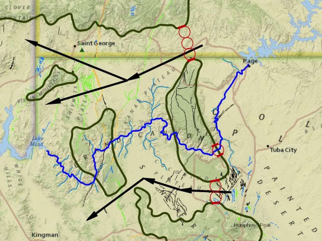
As an aside, it is not believed that the entire depth of the Grand Canyon formed with one episode of a waterfall cutting back. Slope retreat of the canyon sides makes it obvious that the canyon formed gradually over long periods. There easily could have been episodes of rapid cutting back, due to either a relative uplift of the Grand Canyon region or the breaking through by the river of a hard layer into a softer layer, which would create a waterfall cutting back wherever this happened. Indeed it seems that several different things have occurred that affected the formation of the canyon and that it could have formed by several processes in different stages. I also have to think that the depth of the canyon, getting down to the level of the bottom of the fault lines (the supergroup), could have essentially caused less resistance to further uplift allowing it to focus along the general path of the canyon. The Glen Canyon ... indeed. For any who are geographically challenged the town of Page at the upper right of this image:
Is the bottom of Lake Powell (where the dam is) and of the Glen Canyon.
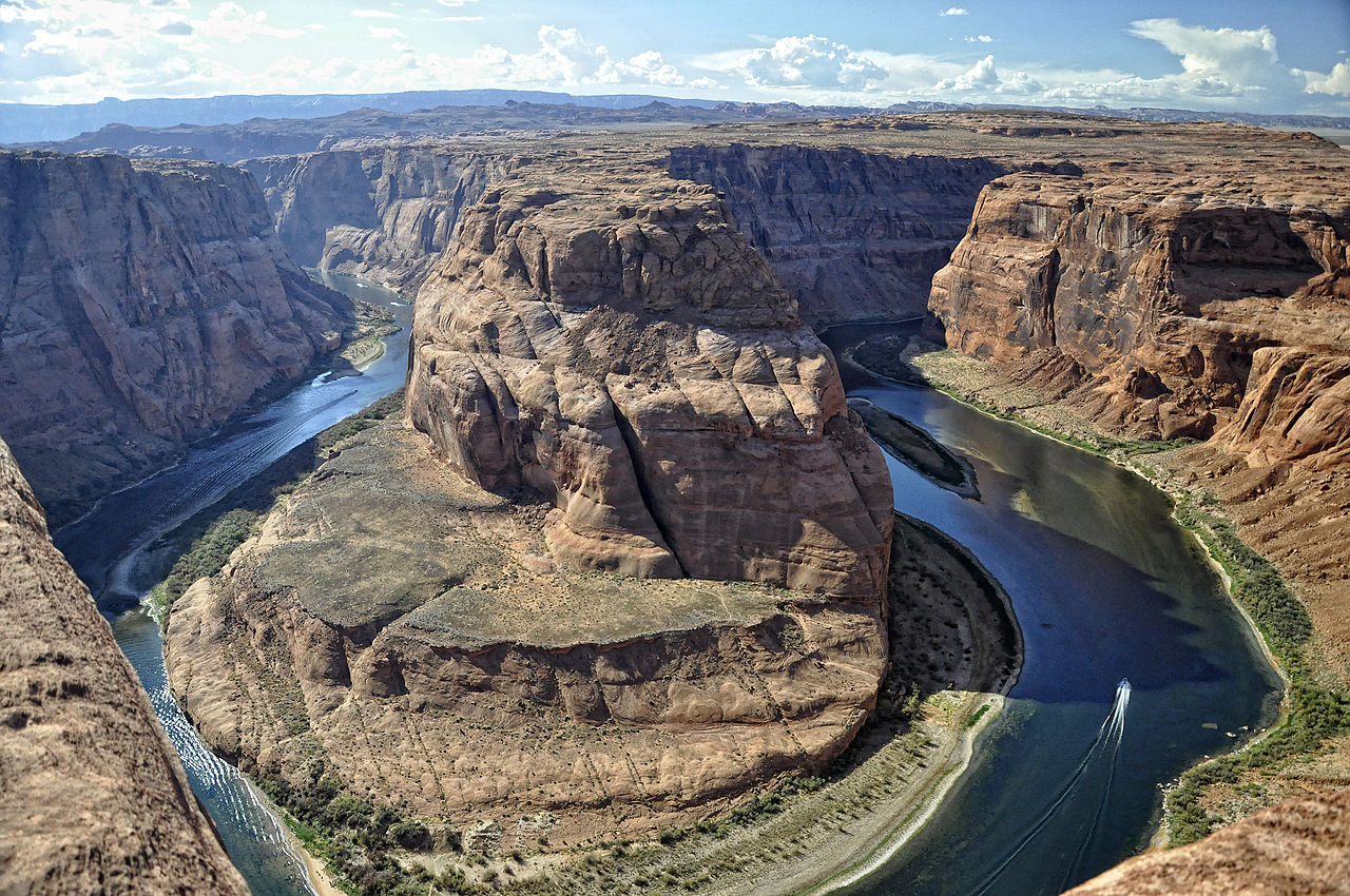
I look at that ledge on the inside of the bend and see old riverbed -- that the meander was originally in this location. Erosion around curves like this is fastest at the outside of the bend, and erosion through the hard layer would occur there first, and once through it dug a new channel down in its current location. Slope retreat would also be greater around the outside due to the undercutting effect of the current. Then there is this image:
Incised meanders that are about to be overcut. You can also see the river undercutting the outside curves. Rainbow arch is also there ... Add to visit wish list. Edited by RAZD, : tribs Edited by RAZD, : location Edited by RAZD, : splg Edited by RAZD, : piclinkby our ability to understand Rebel☮American☆Zen☯Deist ... to learn ... to think ... to live ... to laugh ... to share. Join the effort to solve medical problems, AIDS/HIV, Cancer and more with Team EvC! (click)
|
||||||||||||||||||||||||||
|
RAZD Member (Idle past 1435 days) Posts: 20714 From: the other end of the sidewalk Joined: |
... "over 3000 cubic miles" in an area of 20,000 square miles. ... Thanks. Still the elevation is apparently below the ridge elevation, showing that uplift has occurred since the lake drained.
And to answer Percy, I did find that graphic of the backwards moving waterfall very interesting, but I don't recall anything anyone said describing anything like that. It was, several times. Here is one from Message 1132:
Once the river has become incised to the point where spring floods remain within the walls its pattern is set, including all the meanders. Continued uplift continues this process. This image is from that slide show I reference a while ago (with the hydrological information):
Notice how different stages of uplift and subsequent headcutting develops different flat levels within the canyon. This uplift is still continuing, it can be measured and compared to the ages for the speleothems that record the stages of canyon development over time and see that the uplift rates observed today are sufficient to explain the canyon development by this process. The technical term is headcutting. The theoretical canyon drawing shows this occurring in three places, but it could be one at a time. Percy mentioned this process many times, and it is how the canyon would form from west to east, a formation pattern that the speleothem dates show.
... but I don't recall anything anyone said describing anything like that. Possibly you skipped over it every time. by our ability to understand Rebel American Zen Deist ... to learn ... to think ... to live ... to laugh ... to share. Join the effort to solve medical problems, AIDS/HIV, Cancer and more with Team EvC! (click)
|
||||||||||||||||||||||||||
|
RAZD Member (Idle past 1435 days) Posts: 20714 From: the other end of the sidewalk Joined: |
The fact that fluid mechanics analyses explain clearly why only slow flow on relatively flat surfaces forms meanders. The fact that field work and lab experiments have consistently shown the same result, meanders are only formed by slow flow on near-flat areas. OK, but I never said they didn't. I've only wondered about the DEEP meanders which seem to have formed differently. There must have been a stage in the formation of the GC where water did meander across a plain. But you still haven't convinced me about how it cuts deeply. Here's one description that suggests that meanders eventually defeat themselves, which is the opposite of the deep-cutting GC meanders.
Also, as a river builds up its levees and raises itself over the floodplain, the slope and the transport power of the stream decrease, the channel fills gradually with sediment, and finally (often during a flood) the river will breach its levee (this process is called avulsion) and follow a steeper path down the valley. But doesn't make a deeper meander. Correct, but that is not the only thing going on here: uplift instigates headcutting, and this causes the meanders to become incised into the plain. Once incised it is no longer able to jump the banks and spread out onto the floodplain so the transportation of the material continues. by our ability to understand Rebel American Zen Deist ... to learn ... to think ... to live ... to laugh ... to share. Join the effort to solve medical problems, AIDS/HIV, Cancer and more with Team EvC! (click)
|
||||||||||||||||||||||||||
|
RAZD Member (Idle past 1435 days) Posts: 20714 From: the other end of the sidewalk Joined: |
The second part of this makes sense, great, "ONCE INCISED" it's just going to cut deeper, great. So far so good ... Good.
... but if over time meanders on a plain build the river level higher with deposits as that quote I posted claims, I'm no longer sure about all this. Those deposits occur when the water floods over the banks and the flow slows down. This is how flood plains develop in flat areas, this is why flood plains are fertile soils, because of the depositing of fine materials (particles smaller than sand). These would be seasonal occurrences (spring floods, Nile river monsoon floods, etc)
But the first part is still like something from down the rabbit hole. How can UPLIFT "instigate" headcutting? This sort of thing is said all the time here and just threatens to make my head explode. Say I do an experiment like the one in the video with the large box of dirt (I wish I could do that sort of thing), and I get a little river running across a flattish surface (I'd first wet it and pack it hard so the water wouldn't dig into it the way it did in the video), having fun watching it make meanders etc. Say the box is suspended by cables and I can crank up the whole box to lift it to a higher level. I am NOT going to get that little river cutting more deeply into the dirt. Or do you say otherwise? You would need to tilt it a little bit to ensure the flow crosses the box. With a little trial and error you could find a slope that allow the water to flow across the surface but doesn't erode it. You would also need to play with the flow rate to find the point where it would meander rather than just flow straight down. Your "thought experiment" problem is that you are simply lifting the whole enchilada so that doesn't really model what happens at the boundary of the uplift. You need to divide your box in two and then lift one an inch or two compared to the other to create a small waterfall\erosion zone. This should erode the bottom from that point upstream similar to what is shown in the video, but it may not get all the way to the other end of the box yet -- with homogeneous material (sand) it will cut the top of the erosion hot spot faster than the base and end up with a sloped bottom from the lift point to the upstream end of the box. The bottom of the channel will erode until it reaches the point where is is flat enough that erosion does not occur anymore, and this could be steeper than the slope you started with as there could be a range of slopes below which the erosion doesn't occur and where meanders occur. The material that is eroded from the first (upstream) box will either be deposited in the second (downstream) box in a delta like manner, deposited along the flow as it meanders across the lower box (creating oxbows), or carried through the second box (depending on the slope of the box and the water flow rate). Lift the first box another inch and the process will continue. With several repeats you should be able to incise the upstream section across the box. You can also do it with three hinged panels so that as the upstream end is lifted the middle section gets tilted to a greater slope creating a sloped erosion zone. This should still result in an incised channel from the tilted section upstream and a delta or flat meandering stream that spreads deposits out in the lower section.
And certainly if the uplift occurs in the path of a river so that there is an incline the river would have to climb to keep its path, it's not going to run along the uplift at all but around it, or pool up in front of it. If it were a point uplift and that occurred before the meander were incised I would agree. If it were a ridge uplift across the path of the river then it would cause the water to collect on the upstream side until it reached a level it could flow over the crest of the ridge. This could be modeled with the 3-section hinged box by lifting the upstream hinge if the box sides are tall enough to contain the water behind the ridge. Again it is possible that with the whole apparatus tilted to the maximum slope where meandering occurs that a small lift of the hinge area would still leave the upstream side with a downslope for the water to flow over. This should create an erosion zone at the hinge such that you can continue to lift the hinge slowly and the water will continue to cut through and erode back down while the side at the hinge lift zone become incised. Follow? Now your box model just became a little more difficult.by our ability to understand Rebel American Zen Deist ... to learn ... to think ... to live ... to laugh ... to share. Join the effort to solve medical problems, AIDS/HIV, Cancer and more with Team EvC! (click)
|
||||||||||||||||||||||||||
|
RAZD Member (Idle past 1435 days) Posts: 20714 From: the other end of the sidewalk Joined: |
Lake waters would not gather in an uplifted region, and there's no evidence of a lake ever overlaying the entire Grand Canyon area. Austin's "Lake" is based on filling the land up to the ridge rim and flooding both sides. The "lake" is then the area east of the ridge, but the plan shows water on both sides.
This requires water flowing uphill into the Glen Canyon area. And what about the canyons upstream from Glen Canyon in Canyonlands National Park in Utah? And what about the canyons upstream from that in Colorado? Your lake that releases a catastrophic flow needs to be higher in elevation than all the canyons it supposedly creates, which puts it atop the Rockies. It fills up to Page and the Powell Dam and then merges with Lake Powell in the plan that I saw, and fills in a little over that. He doesn't "uncut" Glen Canyon so it is just not mentioned\considered as far as I can see.
Faith Message 1389: ...apparently picturing it draining away completely into the canyon from about its center. If you think of it that way you could have it completely filling up something like Glen Canyon before draining away and leaving that canyon there. This does not explain the formation of Glen Canyon.  by our ability to understand Rebel American Zen Deist ... to learn ... to think ... to live ... to laugh ... to share. Join the effort to solve medical problems, AIDS/HIV, Cancer and more with Team EvC! (click)
|
||||||||||||||||||||||||||
|
RAZD Member (Idle past 1435 days) Posts: 20714 From: the other end of the sidewalk Joined: |
What do you think about this guy's explanation for the formation of the canyon? He incorporates Lake Bidahochi, but doesn't make it the central player. It seems to give the cutting process a boost in the early stages. That works, mostly. An important point that is not well emphasized is the headcutting with the fourth image causing the river to be incised across the Hualapai drainage system working back from the west end and initiated at the uplift boundary area. One problem I have is a very small tributary off the Kaibab plateau headcutting through it.
Also, in the video, he mention that the Bidahochi deposits were green shale (?) which can only be laid down in deep water. But everything else I have read about Lake Bidahochi suggests it was very shallow and ephemeral. Who is right? How deep is deep? Lake Suigetsu is ~100 ft deep with green clay layers that would be a predecessor to the shale. Edited by RAZD, : ..by our ability to understand Rebel American Zen Deist ... to learn ... to think ... to live ... to laugh ... to share. Join the effort to solve medical problems, AIDS/HIV, Cancer and more with Team EvC! (click)
|
||||||||||||||||||||||||||
|
RAZD Member (Idle past 1435 days) Posts: 20714 From: the other end of the sidewalk Joined: |
Follow? Sorry, no, as said above. Okay let's see if we can break it down.
I would expect to aqccomplish that by keeping the box level but simply patting the dirt into a very slight slope from top to bottom. I did have that in mind. Either would work at this stage, developing a meandering stream. It might be easier to gradually tip the box until water flow, rather than try to guess the right slope, and you can try a number of various slopes to see what the range is where meanders vs relatively straight channels form.
No, but in the original statement nothing was said about the boundary, the whole message is simply that "uplift instigates headcutting." But OK, let's assume the boundary part was unintentionally excluded. So really you are dealing with the same situation I just answered HBD about. This river is flowing along and it encounters an UPSLOPE. ABE: But in this case I'd expect it to lose its meanders altogether. To get the meanders to incise shouldn't the whole meandering part of the river be uplifted? Never mind, I suppose this is what you have in mind preserving by hinging the box. But unfortunately now I'm SO lost I think you do have to start over. Sorry /ABE. Okay, lets see if we can break it down. The original plain before any uplift was fairly flat, and this is what we have modeled so far. When the plain uplifts per your original thought to lift the whole box then there is effectively no change inside the box. What we have at the Grand Canyon is the boundary of the uplift at the western end of the canyon that we need to model.
Or I'd simply build half the wet packed dirt an inch or two higher than the other half so that the water flowing from the lower level will eventually encounter the higher. I assume I'd be building a gradual slope up to the higher level as well. Again, either would work at this stage, however one of the problems with your approach is that it is static and represents an all-at-once uplift rather than a gradual process. At this point we have demonstrated the formation of meanders, yes? With two adjoining boxes you can start with your packed plain with a slight slope, sufficient to form the meanders, then you can introduce uplift as a gradual incremental process or a series of steps. My gut feeling is that the headcutting won't progress to the other end of the box from a small initial uplift but will accomplish this after several sets of uplift. Certainly however we should see the stream becoming incised from the downstream end of the uplift as headcutting proceeds to the upstream end, even if there isn't the dramatic drop shown in the video..
This I don't see. In the video the water wasn't dealing with an upward slope, it was simply eroding upstream across a plateau. ... This is confusing different stages of uplift, or different sections. The Kaibab is at the eastern end so the headcutting west of that isn't affected by that uplift. Different parts of the puzzle as it were.
... In fact one thing that was odd about that video was that it didn't take into account that there would have been an upslope onto the uplift that the river would have had to encounter as it came down from the Rockies; it had the river running down and across the plateau with no upward slope at all in its path. ABE: It also showed no meanders although the plateau was shown as fairly flat /ABE So we can assume that we have demonstrated the formation of meanders, and then a process that gets those meanders incised into the upstream uplifted box section, yes? Now we need to create the ridge by uplift.
Yes, or I could just build the ridge into the dirt. Again this could work, however it would once again be an all-at-once model of the complete uplift, when what we need to model is a gradual process. Lets break it down again: we've developed meanders, and we've developed incised meanders, and now the question is what happens with a ridge forming uplift perpendicular to the average flow. So we can reform the sandbox and create an initial incised meander arbitrarily from the bottom of the downstream box to the top of the upstream box. What we want to do is gradually lift the juncture of the boxes where they meet at the middle while maintaining flow, tipping each box higher at the middle, Limit this uplift so that the water stays in the channel and keep lifting as the sand erodes at the lifted juncture point. You will likely see increased erosion of the channel in the downstream box and headcutting back along the upstream box from the juncture erosion zone. Eventually the stream should level out even though we have created a change in slope of the rims. Remember this picture?
Don't worry about the formulas, just look at the lower diagram -- "section 1" would be similar to the start of our tilting uplift at the juncture of the two boxes: initially there is just a flatter slope upstream than downstream, and increased erosion at the juncture trying to flatten the bottom to match the upper diagram. As that occurs we increase the tilting uplift at the junction point to recreate section 1 with the bottom of the stream and let it even out again. As we continue the uplift cycle the river bottom will continue to transition between two sections at slightly different slopes and one continuous slope, but the rims will begin to form a peak. Keep doing this slowly enough and step by step the rims will create a peak while the river remains flowing through as it did before the lifting.
Too bad, I'm completely lost now. I didn't expect you to keep up the separate boxes idea, the waterfall erosion idea doesn't seem to fit the situation of a river's having to climb a slope, and the whole picture you are pursuing just isn't working. That's why we need to break it down into a couple of steps because there were different stages of uplift and different areas behaved differently.
Changing the terrain which requires the hinged sections already makes it more difficult than I wanted it to be but that part's not the problem as much as the rest of what you've said. Is that clearer now? by our ability to understand Rebel American Zen Deist ... to learn ... to think ... to live ... to laugh ... to share. Join the effort to solve medical problems, AIDS/HIV, Cancer and more with Team EvC! (click)
|
||||||||||||||||||||||||||
|
RAZD Member (Idle past 1435 days) Posts: 20714 From: the other end of the sidewalk Joined: |
Well I've been pondering it a while and have to give up for now. Would it really increase the velocity sufficiently to offset its overflowing its banks behind the barrier? Would it really erode down far enough to level it with the former riverbed and deepen the banks on the uplift? etc etc etc. It seems a very odd way to run a river but I have to think about it some more. Consider what happens when a bank collapses into a river. The collapse does not fill the channel nor raise the river out of the banks. How long would that material from the collapse remain there? Would the water flow faster over the material than it did before the collapse? Would that not increase the erosion so that the material would be eroded away to the original streambed? by our ability to understand Rebel American Zen Deist ... to learn ... to think ... to live ... to laugh ... to share. Join the effort to solve medical problems, AIDS/HIV, Cancer and more with Team EvC! (click)
|
||||||||||||||||||||||||||
|
RAZD Member (Idle past 1435 days) Posts: 20714 From: the other end of the sidewalk Joined: |
I didn't actually spend too much time analyzing the scenario in that video. I couldn't piece together a coherent narrative using only what they presented, and I'm not sure how much or how accurately the story the scientists were trying to tell was communicated, or even how much they might have agreed with one another. I bet those scientists cringed when they first saw it. Also, there's a lot of disagreement about the age of the canyon, and they didn't even mention that controversy. Yeah, I don't see a consistent picture either. There's also herebedragons post with another alternative.
It's a fantastic illustration of undercutting at the outside of meanders, which we couldn't see if the river level weren't so low. ... Actually I believe this section is just northeast of of Powell Dam, along the southwest branch, and that the water here is impounded behind the dam, so with lower water we would see more undercutting. The smoothness could be partially due to raising and lowering of the water levels for flood control (to reduce the peak flows in the Grand Canyon), but based on the size of the boat that would be a lot of water. by our ability to understand Rebel American Zen Deist ... to learn ... to think ... to live ... to laugh ... to share. Join the effort to solve medical problems, AIDS/HIV, Cancer and more with Team EvC! (click)
|
||||||||||||||||||||||||||
|
|
Do Nothing Button
Copyright 2001-2023 by EvC Forum, All Rights Reserved
![]() ™ Version 4.2
™ Version 4.2
Innovative software from Qwixotic © 2024