|

Understanding through Discussion |
|
|
Register | Sign In |
|
QuickSearch
Summations Only | Thread ▼ Details |
|
Thread Info
|
|
|
| Author | Topic: Why the Flood Never Happened | |||||||||||||||||||||||||||||||||||||||||
|
RAZD Member (Idle past 1435 days)  Posts: 20714 From: the other end of the sidewalk Joined: |
The strata were maybe two miles deep from the basement up, a mile from the Tapeats up, and then you need the depth of the ocean on top of that to get the Kaibab on the floor of it, without the uplift. Each one deposited in low elevations, most underwater. The sedimentary deposits on Mt Everest are marine in origin because that area was once below sea level and they have been lifted by the tectonic forces from colliding plates. What's the problem?by our ability to understand Rebel American Zen Deist ... to learn ... to think ... to live ... to laugh ... to share. Join the effort to solve medical problems, AIDS/HIV, Cancer and more with Team EvC! (click)
|
|||||||||||||||||||||||||||||||||||||||||
|
RAZD Member (Idle past 1435 days) Posts: 20714 From: the other end of the sidewalk Joined: |
You are now shouting non-sequitur comments with no quotes.
Settle down.by our ability to understand Rebel American Zen Deist ... to learn ... to think ... to live ... to laugh ... to share. Join the effort to solve medical problems, AIDS/HIV, Cancer and more with Team EvC! (click)
|
|||||||||||||||||||||||||||||||||||||||||
|
RAZD Member (Idle past 1435 days) Posts: 20714 From: the other end of the sidewalk Joined: |
They deposited one on top of another. The elevation doesn't STAY low that way, it keeps getting higher. ... Relative to what frame of reference, though, that is an important question. Certainly in a marine environment deposition of sediment and the debris from marine life (shells etc) on the sea bed can continue to occur as long as water covers the sediment. This is of course how the marine layers were deposited, whether in shallow or deep seas in an environment where water covered the seabeds.
... The Himalayas were TILTED up to their height, OUT OF THE WATER, ... Actually they were lifted, buckled and tilted. Some layers are horizontal. some are at angles and some are wrinkled as a result. Getting back to the Grand Canyon marine layers, however, either the sea level can drop or the seabed (bottom) rise to expose the seabed so it becomes a land surface environment. This would be caused by tectonic action as well (more later). The exposed surface can then be eroded (wind, rivers etc), lived on, and deposited on (sand, alluvial soils etc). This does not need to be high, it could be a low swampy area, (which would also be a relatively flat environment) and it could be an alluvial plain that would form a long wedge shape, over such a long distance that they appear flat and level. If the sea recedes there is no reason for the orientation of the marine sediment to change. Spreading of sea floors and pushing up mountains between distant plates would cause the sea level to fall in other areas distant from the colliding plates. Taking the Himalayas as an example: as the mountains are pushed up high above sea level there is a net reduction of land mass around the seas -- it's all being piled up in one place -- so the sea level in the area of the Grand Canyon (and elsewhere) would fall. Erosion of mountains and land formations would then deposit material back in the seas over time. This sedimentation on ocean bottoms all over the earth would tend to make seas rise as the bottoms of the ocean basins were gradually filled\raised by the sediment (same process as our previous marine layer formation). When these seas then rose to cover what had been exposed previously, new marine type sedimentation would begin to occur on this area, and it would still be relatively flat and horizontal. This new layer would differ from the previous marine deposit by the age of the materials being deposited and by the make-up of the materials being deposited, different elements, different minerals, different life-form debris. Thus even if it is basically the same material, a limestone (there are many types of limestone), it is specifically different and this difference can be measured and quantified. This process can be repeated several times, as tectonic action has been a common factor in the natural history of this planet. The shape of the planet as a whole affects the level of the seas and the exposure of land masses to erosion, they don't have to be local to the Grand Canyon area to change the area from shallow seas to low level swamps and alluvial plains to shallow seas to low level swamps and alluvial plains, etc etc etc. We would expect this to leave evidence of meandering streams through the swamps and alluvial plains from surface exposure, and fill those in with marine sediment when they are shallow seas. This matches the evidence we see with the Temple Butte formation and the Surprise Canyon formation and the layers above and below them.
... Again, the Kaibab is a mile above the Tapeats which is above another depth of strata, and then you have to get the Kaibab onto the bottom of the ocean. ... Again, relative to what frame of reference? As noted above this is an important question, as you can use sea level and observe that the land rises and falls or you can use the land and observe that the sea rises and falls. A better frame of reference would be something not affected by tectonic action (as land level and sea level are), such as mean distance from the center of the earth (but this is difficult to determine for ancient deposits). And the Kaibab is also a limestone, so it was deposited in a marine environment. Kaibab
quote: also see USGS URL Resolution Error Page So this too is consistent with the pattern of rising and falling seas relative to the land.
... the strata in the GC area stayed flat and yet were DEEP underwater for the deposition of the Kaibab. As noted the effects of tectonic activity in the rest of the earth would be changing sea levels relative to the land in this area, and there is no cause for it to change from relatively level, flat depositions, either marine or terrestrial at this point. Another drop in sea level the exposes the surface to erosion again, by wind and water, and the formation of an alluvial plain with a meandering river ... the ancient Colorado. Then the behavior of the tectonic plates shifts and this area is affected, uplift occurs and the whole plain is lifted and erosion increases, being most affected where there is a difference in grade between the lifted area and the non-lifted area, the "base" level for the river (the bottom end) and proceeding upstream (see comments by Percy on this headward progress). Once the river has become incised to the point where spring floods remain within the walls its pattern is set, including all the meanders. Continued uplift continues this process. This image is from that slide show I reference a while ago (with the hydrological information):
Notice how different stages of uplift and subsequent headcutting develops different flat levels within the canyon. This uplift is still continuing, it can be measured and compared to the ages for the speleothems that record the stages of canyon development over time and see that the uplift rates observed today are sufficient to explain the canyon development by this process. Simple  Edited by RAZD, : exampleby our ability to understand Rebel American Zen Deist ... to learn ... to think ... to live ... to laugh ... to share. Join the effort to solve medical problems, AIDS/HIV, Cancer and more with Team EvC! (click)
|
|||||||||||||||||||||||||||||||||||||||||
|
RAZD Member (Idle past 1435 days) Posts: 20714 From: the other end of the sidewalk Joined: |
Re: Hey Atheos c.: Here's a Bunch of Granular Studies for you One of the links:http://lisgi1.engr.ccny.cuny.edu/~makse/research.html These experiments all are done with dry materials, and the interactions of particles when the angle of repose is developed, which is affected by particle size and angularity, and thus would be indicative of the behavior of dry sands in dune formation. And it shows what we see in sand dune formation. This behavior would be affected by being submerged, so once again this shows that the sandstones showing the patterns of sand dune formation would have occurred in a dry environment. by our ability to understand Rebel American Zen Deist ... to learn ... to think ... to live ... to laugh ... to share. Join the effort to solve medical problems, AIDS/HIV, Cancer and more with Team EvC! (click)
|
|||||||||||||||||||||||||||||||||||||||||
|
RAZD Member (Idle past 1435 days) Posts: 20714 From: the other end of the sidewalk Joined:
|
Comparing typical floods today with THE Flood is absolutely ridiculous, ... Why? How does the behavior of water change?
... which really ought to be obvious, ... So then you should have plenty of objective empirical evidence and known processes that you can point out and show why it is obvious. If you can't do that then it is NOT obvious.
I don't know why you persist in it. A flooding river is NOT to be compared with a worldwide rise in the ocean ... . Because a flooding river does carry sediment and it deposits sediment in the flood plain when the velocity of the water slows enough for sedimentation to occur. And because the size and shape of the particles affect how long they are carried by flows of different energy. A rise in sea level does not cause much erosion other than the wave action at the shoreline boundary, with deposition close to that shoreline.
... which carried in it every kind of sediment imaginable. Well I can imagine sediment the size of the moon and consider that such particles would be difficult to move by rising water levels. Thus we can obviously qualify your statement to what we can reasonably imagine. Then we get to the different opinions of what is reasonable. Certainly the behavior we see in floods that can be observed is behavior we can reasonably imagine, but floods we cannot observe not so much. We can extrapolate rather than demonstrate, but we would need to have a model of behavior of the water that is different in order to have a basis for any such extrapolation to be reasonably imagined. To deposit small dense particles of clay below large dense particles of rock and sand is not something that can be reasonably imagined within a continuous water environment. And no, the behavior of dry materials in cross-bedding deposition like sand dunes is not a model for behavior of those same materials in a water environment. In a water environment an alluvial fan is developed with deposition of the large dense particles near the mouth and the finer particles deposited further out, because the water slows down as it spreads out. You do get a cross-bedding near the mouth as the alluvial fan develops, but the pattern is slightly different from the dry material pattern and the angle of repose is different in the marine environment, and these differences can be used to distinguish one from the other. And you can observe this behavior, so it can be reasonably imagined. by our ability to understand Rebel American Zen Deist ... to learn ... to think ... to live ... to laugh ... to share. Join the effort to solve medical problems, AIDS/HIV, Cancer and more with Team EvC! (click)
|
|||||||||||||||||||||||||||||||||||||||||
|
RAZD Member (Idle past 1435 days) Posts: 20714 From: the other end of the sidewalk Joined: |
Right, you apparently overlooked the mention of how it's no different in water. Incorrect. The angle of repose is different and the particle distribution pattern is different and this shows up in details at the top and bottom of the depositions process. These differences are discernible. This also creates layers at an angle and not in a horizontal pattern, so no matter how you misunderstand the process it doesn't explain your problem with sorting of deposits.
But now you need to answer the question I've asked before: how did that enormous deposition of dry dune sand get packed down and flattened out in its current form as the Coconino sandstone layer which fits right in as far as its form goes, a huge rock pancake that is, along with the limestone and the shale and all the rest of it. Erosion. Encroaching seas as the water levels rise would mean wave action eroding high dunes and filling valleys. by our ability to understand Rebel American Zen Deist ... to learn ... to think ... to live ... to laugh ... to share. Join the effort to solve medical problems, AIDS/HIV, Cancer and more with Team EvC! (click)
|
|||||||||||||||||||||||||||||||||||||||||
|
RAZD Member (Idle past 1435 days) Posts: 20714 From: the other end of the sidewalk Joined: |
You don't say HOW it would be affected by being submerged, and cross bedding does occur in water: In a dry environment such as a sand dune the predominate erosive force is wind. Wind sweeps across dunes in a wide linear pattern. Winds tend to deposit material near the tops of the dunes on the leeward side, and the large particles tend to roll and end up at the bottom while fine material tends to accumulate near the top (per the link experiment). The very bottom would tend to be all large grain that is overlain by later deposits (look at the experiment pictures). In a wet environment such as an alluvial fan, the predominant erosive force is water carrying sediment, and wave action at different tide levels and it spreads out in a radial fan rather than a linear pattern. As it spreads out water velocity drops and deposition starts with large particles settle out first, and tend to deposit at the tops while finer particles settle out later and tend to deposit at the bottoms. The very bottom would tend to be all fine material that is overlain by later deposits. Angle of repose - Wikipedia
So if it is sand at 34° then it was dry deposition. If it is clay at 15° then it is wet excavated (water filled). These are measurable differences. By the nature of cross-bed formation these deposits on the backside will always be at the angle of repose for each material, because the material is deposited at (or very near) the tops of the backside. Notice how if we had a mixture of sand and gravel in a dry environment that the gravel would tend to build a flatter slope than the sand, so the gravel would always run down the sand slope to spread out at the bottom at its angle of repose and be covered by later deposits, making a coarse base to the formation. Notice how if we had a mixture of clay and sand in a water filled deposition environment that the sand would want to build a steeper slope than the clay, so the clay would always run down the sand to spread out at the bottom at its angle of repose and be covered by later deposits, making a fine base to the formation. Notice how going from a dry environment to a water filled one changes the stability of the formation and it would cause collapse down the backside and filling of the valleys -- another behavior that could be observed.
Atheos said the angle of repose in water versus air is different and supposedly the Coconino's is the dry kind. And he also said the dry sand angle was 34° and that in water it was less. And you still don't have an explanation for the fine shale sediment below the coarser dense sandstone formation in horizontal layers. by our ability to understand Rebel American Zen Deist ... to learn ... to think ... to live ... to laugh ... to share. Join the effort to solve medical problems, AIDS/HIV, Cancer and more with Team EvC! (click)
|
|||||||||||||||||||||||||||||||||||||||||
|
RAZD Member (Idle past 1435 days) Posts: 20714 From: the other end of the sidewalk Joined: |
Erosion. Encroaching seas as the water levels rise would mean wave action eroding high dunes and filling valleys. But of course this would get the sand WET, which changes the angle of repose. So this isn't going to work as an explanation of how the dry "dunes" got packed, flattened and lithified. But of course if it's the only way it could be done, it supports the FLOOD. No Faith, flooding with encroaching seas would not affect the internal structure deep inside the dunes, it would cause slumping of the back side until the new angle of repose was developed and the wave action would erode the peaks and deposit them in the remaining valleys. Sections of the dunes not affected by either of these actions would remain in their relative orientations. Packed in dry orientation, then the surface is eroded, averaged out to flatten it, then it is compacted. Edited by RAZD, : ..by our ability to understand Rebel American Zen Deist ... to learn ... to think ... to live ... to laugh ... to share. Join the effort to solve medical problems, AIDS/HIV, Cancer and more with Team EvC! (click)
|
|||||||||||||||||||||||||||||||||||||||||
|
RAZD Member (Idle past 1435 days) Posts: 20714 From: the other end of the sidewalk Joined: |
Oh I get it, it gets wet but it doesn't get wet. Of course. It gets wet but (a) it is not saturated water filled sand and (b) it doesn't have anywhere to go, there is no density distribution or mechanical perturbation to cause the sand to move so there is no cause for it to move. It is the same density as the sand next to it so it stays put. The sands at the surface and on the downslopes ARE affected and they DO have somewhere to go -- the valleys. And (c) damp sand has a higher angle of repose ( 45° ) than dry sand because the surface tension of the water holds the sand together. This is why you can build sand-castles and why they crumble as the sand dries or as even a calm tide fills around it. With already compacted sand you can't get enough water into the formation to cause it to slump ... without mechanical action. If, however, you vibrate the sand (mechanical perturbation) it will "liquefy" (behave like a liquid) and slump (think quicksand). So if you had an earthquake you could have internal liquefaction failure. The existence of the sand layers at 34° is evidence not only of dry formation and compaction but of the absence of earthquakes before lithification. In other words it was already converted to rock before you could have your rapid violent tectonic action to create all the uplift in one big eruption of tectonic movement. Edited by RAZD, : .by our ability to understand Rebel American Zen Deist ... to learn ... to think ... to live ... to laugh ... to share. Join the effort to solve medical problems, AIDS/HIV, Cancer and more with Team EvC! (click)
|
|||||||||||||||||||||||||||||||||||||||||
|
RAZD Member (Idle past 1435 days) Posts: 20714 From: the other end of the sidewalk Joined: |
If you have to go to a ten-gallon aquarium, I might call it off though..... How about a blow up pool and a 5-gallon bucket of sand and a plastic bucket and shovel ... and a sunhat, gotta have a sunhat ...  by our ability to understand Rebel American Zen Deist ... to learn ... to think ... to live ... to laugh ... to share. Join the effort to solve medical problems, AIDS/HIV, Cancer and more with Team EvC! (click)
|
|||||||||||||||||||||||||||||||||||||||||
|
RAZD Member (Idle past 1435 days) Posts: 20714 From: the other end of the sidewalk Joined: |
Submerged is lower?!! Have I not been telling you that for a Long While?! Not sure she understands the difference between "wet" and "submerged" That paper (1950) was also a review of other papers where descriptions of the materials were inconsistent. Since then descriptions have been formalized to more accurately describe different materials. by our ability to understand Rebel American Zen Deist ... to learn ... to think ... to live ... to laugh ... to share. Join the effort to solve medical problems, AIDS/HIV, Cancer and more with Team EvC! (click)
|
|||||||||||||||||||||||||||||||||||||||||
|
RAZD Member (Idle past 1435 days) Posts: 20714 From: the other end of the sidewalk Joined: |
Here for instance is a paper that has identical numbers for dry and wet sand, though "moist" is higher. However. "submerged" is lower! Yes and in sand dunes it is dry, while underwater it is submerged. While "moist" and "wet" refer to water filling the interstices of sand and holding the sand particles together with surface tension, and thus they refer to sand on land. This is like a handtowel that you wet: moist would be the point where you could wring out the towel, while wet would represent the range from moist to the most water that could be held by the towel. Once you put it underwater the surface tension is no longer a factor. Have you ever made drip castles with sand? You start with sand submerged in water and pluck some between your fingers and your thumb. As the water drips out it will carry sand that you can stack up in towers and walls a drop at a time (with practice). The sand is deposited in a wet condition, and the surface tension holds it together. by our ability to understand Rebel American Zen Deist ... to learn ... to think ... to live ... to laugh ... to share. Join the effort to solve medical problems, AIDS/HIV, Cancer and more with Team EvC! (click)
|
|||||||||||||||||||||||||||||||||||||||||
|
RAZD Member (Idle past 1435 days) Posts: 20714 From: the other end of the sidewalk Joined:
|
I was surprised to see that "wet" was the same angle as "dry," because ever since Atheos brought it up I've been told dry is 34 degrees and wet is 45 degrees, so that is the comparison I've been focused on. I wasn't going to pursue this topic at all but then I looked up a few things and found that paper, in which I first noticed that on a couple of tables wet and dry have the same angle instead of what I'd been told, and then noticed the smaller angle for "submerged," and the larger angle for "moist." But the comparison between wet and dry is still the most interesting because of how it had been presented in this thread. You do realize that "wet" in that paper does not mean submerged, yes?
One idea I'd had all along which I now know was wrong, was that the grains themselves were shaped a certain way which accounted for their angle of repose, that they'd been shaped by tumbling either in air as in sand dunes, or in water as in the Flood, and that the different shape is what determined the angle of crossbedding in the sandstone. I thought that Atheos was saying they were SHAPED to lie as they do in the Coconino for instance. Another acknowledgement that you were wrong, and that you misinterpreted what was said. We thank you. Do you know why cross-bedding layers are formed rather than just homogeneous sand dunes?
Turns out that shape does affect angle of repose, though, but it has to do with roughness versus smoothness of the grains. And that should be taken into account as well. Yes, and do you know why there is a difference in angle of repose for dry and submerged? The angle of repose for wet and damp are due to surface tension of water holding the grains in place. You need to think of this as a spectrum of water content in sand. (It doesn't apply to larger grains like gravel because the pieces of gravel are too big and heavy to be held in place by surface tension).
Anyway, now I have a different impression of the whole thing. There is no reason whatever any more to say the sand had to have been dry when deposited because it can have the same angle of repose when it's wet according to more than one table in that paper. No, when deposited by flood water you need to apply the submerged angle of repose. Again, do you know why the angle of repose is different for dry and submerged?
As for the LOWER angle for the sand's being "submerged" it would be submerged during the Flood of course, while it was being deposited, but then what happens when the Flood waters recede? Do we assume the sand retains its "submerged" angle of repose, or wouldn't it then rearrange itself to the "wet" angle, which turns out to be the same as the "dry?" In all these cases there is NO need to assume the Coconino was deposited dry, turns out that's false. How would sand move to "rearrange" itself Faith? It is just as constrained inside the deposit as the sand dune deposited sand is when submerged. Why would the flood deposit sand in thin layers as seen in the Coconino sandstone and not like the muck seen here:
How would a deposition like that have fine layes of cross-bedded grains Faith? What do you think the angle of repose is for this deposition? Turns out the Coconino deposit is still a dry sand aka sand dune deposit because you would have submerged sand deposition at the lower angle of repose. The only thing that can rearrange sand inside a deposit is mechanical shaking while in a submerged condition. If you have mechanical shaking then the sand liquefies and you lose all record of cross-bedding. If your sand magically "rearranged" itself inside the deposit it would lose all record of cross-bedding, unless you have it magically make recreate the layers ... in which case you don't need to worry about how it was deposited, it magically changed to imitate dry sand deposition. Your flood can only deposit sand in a submerged condition, it cannot dry it out and then rearrange it. You also are missing a mechanism to deposit finely stratified layers of sand in your continuous process. You need to play with sand as Coragyps recommends. You don't understand what you are trying to pretend to understand.
ABE: Here's the chart again, from my Message 1151:
SO WHERE ARE YOU, ATHEOS? YOUR CONTENTION HAS BEEN SHOWN TO BE WRONG, OR AT LEAST INCONCLUSIVE. Do you know why there is a range for each category you have clipped from this 1950 article? (Do you have a more current article that confirms this?) Do you know why the angle of repose for submerged sand is lower than the angle of repose for dry sand? I'll give you a hint: the angle of repose is different for different materials because of
Fill in the blanks. Curiously, the angle of repose for dry sand can be calculated. The result is 35° Do you think the angle of repose for submerged sand can be calculated as well? by our ability to understand Rebel American Zen Deist ... to learn ... to think ... to live ... to laugh ... to share. Join the effort to solve medical problems, AIDS/HIV, Cancer and more with Team EvC! (click)
|
|||||||||||||||||||||||||||||||||||||||||
|
RAZD Member (Idle past 1435 days) Posts: 20714 From: the other end of the sidewalk Joined: |
... and it turned out that the only absolutely definite one was 34 degrees for dry sand. ... Not exactly true, but at least you have dry sand correct.
... If you don't like my information, supply your own. I already have, remember this (Message 1144):
quote: * - I added this row since the previous post Note that the "sand (wet) would be comparable to the "clay (wet excavated)" and that the angle of repose for submerged (water filled) clay is not given (it would be lower still). Note that if you piled up wet sand into as steep a hill as possible ... 45° ... then as sand dries out the face would be no longer capable of holding the angle of repose of wet sand, and it would collapse, Just as a sand dune if it was inundated with calm water the face would no longer be able to hold the angle of repose of dry sand, and it would collapse. The sand in the collapsed material would have lost the stratifications from cross-bedding. This face is called the "slip face" for future reference. slip face | geology | Britannica
quote: Also of note is the behavior of sand bars in tidal areas: http://oai.dtic.mil/oai/oai?verb=getRecord&metadataPrefix...
quote: The tidal currents scour the seafloor.
Message 1: Do you know why the angle of repose for submerged sand is lower than the angle of repose for dry sand? I'll give you a hint: the angle of repose is different for different materials because of
Fill in the blanks. Curiously, the angle of repose for dry sand can be calculated. The result is 35° Do you think the angle of repose for submerged sand can be calculated as well? Do you have an answer yet? by our ability to understand Rebel American Zen Deist ... to learn ... to think ... to live ... to laugh ... to share. Join the effort to solve medical problems, AIDS/HIV, Cancer and more with Team EvC! (click)
|
|||||||||||||||||||||||||||||||||||||||||
|
RAZD Member (Idle past 1435 days) Posts: 20714 From: the other end of the sidewalk Joined: |
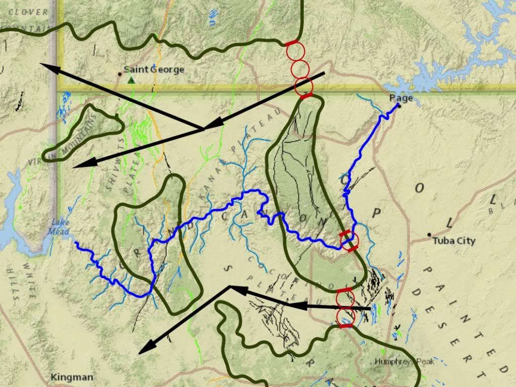
HERE IS THAT CROSS SECTION AGAIN BY THE WAY. LOOK AT THE ALTITUDE LEVELS AT THE SIDE, IT'S ALL ABOVE SEA LEVEL. THE ONLY PART THAT GOES AT ALL BELOW SEA LEVEL IS THE FAR NORTH END OF THE LOWEST STRATA OF THE GRAND STAIRCASE. Message 1083: RAZD you are describing the situation NOW. ... Nuff said. Now lets review again ... I've updated this picture to show some scale:
At some point the flood water was above all these features, while today it is below these features. This means that at some time flood water was at the elevation of all these features as the levels went down. At some point the flood level would be at the 7000 ft topo line, and either (a) the erosion at these two paths was occurring or (b) it had occurred, and either way there would be evidence of active erosion in these two locations. The circles show the widths of 3 paths ...
Scaling from the topo map I get a rough diameter for those circles at ~6.5 miles, or 34,320 ft, so two would be 68,640 ft wide and three would be 102,960 ft wide ... and assuming a triangular cross-section for comparison:
So at the point when the flood filled up to the 7,000 ft topo elevation the path to the south would have ~37% of the capacity of the fully carved canyon, which would still be a substantial erosive force ... and yet there is no canyon there, there is no evidence of an erosion channel across this path at all. And the path to the north would have 111% of the capacity of the fully carved canyon, more than the canyon, and yet ... and yet there is no canyon there, there is no evidence of an erosion channel across this path at all. Why? Edited by RAZD, : why Edited by RAZD, : piclinkby our ability to understand Rebel☮American☆Zen☯Deist ... to learn ... to think ... to live ... to laugh ... to share. Join the effort to solve medical problems, AIDS/HIV, Cancer and more with Team EvC! (click)
|
|||||||||||||||||||||||||||||||||||||||||
|
|
Do Nothing Button
Copyright 2001-2023 by EvC Forum, All Rights Reserved
![]() ™ Version 4.2
™ Version 4.2
Innovative software from Qwixotic © 2024