
|

Understanding through Discussion |
|
|
Register | Sign In |
|
QuickSearch
Summations Only | Thread ▼ Details |
|
Thread Info
|
|
|
| Author | Topic: Why the Flood Never Happened | |||||||||||||||||||||||||||||||||||||||||||
|
RAZD Member (Idle past 1435 days)  Posts: 20714 From: the other end of the sidewalk Joined: |
There is no range given in the second table, it gives the same angle for wet and for dry, not a range. Wet but not submerged. There is a big difference in behavior because of the effect of surface tension in the water holding the sand in place. Underwater this effect is gone and with dry sand it is gone.
No, when deposited by flood water you need to apply the submerged angle of repose. I'm still wondering about this. ... How can it not be underwater when deposited by a flood.
... The paper includes tables comparing angle of repose for sand stacked in air, stacked in air and then submerged, stacked under water, and stacked in air damp. ... Which applies to those conditions if they remain that way.
... . I'd be curious if the angle stays the same as you claim it does when the sand that was wet in any of these scenarios is left alone to dry out. Curiously, that is not what I have said. If you take a stack made when moist -- 45° -- and let it dry out, as the surface dries out it will slump or slide down and when the stack is fully dry the outer shape should be at the dry sand angle of repose -- 34° If you take a stack made underwater -- <30° -- and dry it out it will remain at that angle of repose (or any other angle below the dry sand angle of repose) Do you know why the angle of repose for submerged sand is always lower than the angle of repose for dry sand? I'll give you a hint: the angle of repose is different for different materials because of
Fill in the blanks.  by our ability to understand Rebel American Zen Deist ... to learn ... to think ... to live ... to laugh ... to share. Join the effort to solve medical problems, AIDS/HIV, Cancer and more with Team EvC! (click)
|
|||||||||||||||||||||||||||||||||||||||||||
|
RAZD Member (Idle past 1435 days) Posts: 20714 From: the other end of the sidewalk Joined: |
I want to know why you think that if it was deposited under water the angle of repose would have remained the same after it dried out. Dry sand has a different angle of repose, even "wet" sand does according to those tables, and it's the same as for dry sand. The question remains: If the sand was submerged, deposited in the Flood waters, why should it continue to retain the angle of repose of submerged sand after it has dried out, or even after it has dried to the point of being described as "wet," since it is the water content or lack of it that determines the angle? The angle of repose is the maximum angle a slope of material can stand at -- but it can always be a flatter angle, even (gosh) horizontal ... Once deposited and covered by an additional layer there is no mechanism to change the angled layer orientation inside the formation. Sand does not move when it feels like it Faith -- there has to be something pushing it. Curiously, you have already been told this: what is hard to understand about the concept that once deposited and covered the sedimentary structure doesn't shift, doesn't move, doesn't rotate without a cause, a force, a mechanism.
So, apparently the angle of the crossbedding seen in the sandstone strata is the same as the angle of repose, yes?, ... For dry sand, yes.
... which is therefore the angle of repose of either the dry OR the "wet" sand as reported in those tables. No, because "wet" sand does not cross-bed. The only way cross bedding occurs is when the particles are carried by an erosive agent (air or water for instance) and then deposited when the energy\velocity of the agent drops to the point it can no longer carry the particles -- as when wind or current goes over the top of a dune (dry) or sandbar (submerged). The "wet" and "moist" conditions hold the sand particles with surface tension. Underwater the "wet" and "moist" conditions would be quickly dissipated by water currents into "submerged" conditions. On land any wind that could blow particles out of "wet" or "moist" conditions would also dry it.
Seems to me this COULD be determined by a kitchen table test of the sort Coragyps has proposed I could do with the kit he's offered to send. Indeed. The testing mechanism is fairly simple to make and use.
Submerged sand has a lower, not a higher, angle of repose, ... Indeed. Do you know why the angle of repose for submerged sand is always lower than the angle of repose for dry sand? I'll give you a hint: the angle of repose is different for different materials because of
Fill in the blanks. Edited by RAZD, : clrtyby our ability to understand Rebel American Zen Deist ... to learn ... to think ... to live ... to laugh ... to share. Join the effort to solve medical problems, AIDS/HIV, Cancer and more with Team EvC! (click)
|
|||||||||||||||||||||||||||||||||||||||||||
|
RAZD Member (Idle past 1435 days) Posts: 20714 From: the other end of the sidewalk Joined: |
Once deposited and covered by an additional layer there is no mechanism to change the angled layer orientation inside the formation. Sand does not move when it feels like it Faith -- there has to be something pushing it. Nothing "pushes" it into the angle of repose, it just falls there. I understand it would have to have room to fall, but I would still like to see an experiment or ten done to prove your claim, or disprove it. What "pushes" is gravity, but it operates equally on all the grains, so once a grain of sand is inside a formation it cannot move and the forces actually hold it in place. Only the grains on the outside surface can move ... in a direction with a downward component if the force of gravity and the angle of the surface where the grain rests is greater than the angle of repose for the condition of the material. ie -- if you draw a vector straight down (gravitational force) and resolve it into one vector perpendicular to the surface and one parallel to the surface, then you have one force trying to hold the grain to the surface and one force trying to move it along the surface -- this is how the angle of repose works -- and at some point as you tilt the surface the force pushing the grain to move along the surface wins out over the force trying to hold it in place and the grain moves. Downhill. To a flatter sloped condition.
Here you see the force of gravity, Fg, resolved into two vectors, one perpendicular to the surface, Fn, and one parallel to it, Fp. What holds the block in place is the friction between the block and the surface, Ff. When Fp exceeds Ff the block slides downhill. The force of friction is a reaction force not an action force, so it cannot move the block uphill. All it can do is match the parallel gravity vector Fp until its maximum friction value is reached.
Ff = kFn Where k is the coefficient of friction, a constant related to the textures of the materials, and its value runs from 0 to 1. The friction force is related to the perpendicular force, Fn, of the block and the texture of the surface (coefficient of friction), so as you tilt the surface this force decreases and the resistance to sliding decreases, while the force pushing the block down the slope increases until slippage occurs. You can think of the surface of a material as being a whole bunch of blocks side by side down the slope, so the whole face will slip and pile up in a jumble at the base of the slope, starting a new pile (like the talus piles at the bottoms of cliffs).
How odd, it assumes an angle of repose but it doesn't cross-bed, though dry sand does, at ITS angle of repose. How odd. Can you give a reference for this? It involves the mechanism of how cross-bedding occurs. The material needs to be transported as individual particles that tumble down the slope. Moist and wet particles are adhered by surface tension in the water, so they won't tumble as individual particles. Walk along a beach and the dry sand will be blown down wind but the wet sand will stay in place. Cross-bedding is also a slow process. Fast movement of the air or water will not allow the deposition to take place, and too much deposition at one time will not form thin well defined layers but look more like a mud pile. The sand would not have the time to form the slope except at the last part of the deposition.
So it doesn't just fall into that form although it does just fall into its angle of repose. So you would assume that the formation in northeast Arizona called The Wave, which is made up of that amazing swirly sandstone with crossbedding, wasn't formed in water as I would assume it was, if only because I can't figure out how dry sand in such shapes could lithify. Lithification does not require water saturation. When you form a pile of dry sand the particles land on the surface and either stay there or roll downslope. They roll downslope if the surface is at the angle of repose and stop at the bottom forming a base to build a new layer at the angle of repose up to the top, and when that layer is completed to the top the process starts again with the formation of another new base. Think of a marble instead of the block - it would have very little resistance to rolling down the slope, but if you have a line of marbles to the bottom they will tend to stay until a critical angle is reached.
Yeah yeah yeah but I'm asking about going FROM submerged conditions to "wet" or "dry" conditions. I'm thinking of the condition of its being originally submerged and then the water running out of it leaving it damp or "wet" or even eventually dry. There is no force to move grains up, gravity only pushes down, so a cross-bedded underwater formation would retain that structure when lifted out of a submerged environment and dried. You should now be able to fill in two of the blanks: Do you know why the angle of repose for submerged sand is always lower than the angle of repose for dry sand? I'll give you a hint: the angle of repose is different for different materials because of
So can you fill in the blanks? Edited by RAZD, : kby our ability to understand Rebel American Zen Deist ... to learn ... to think ... to live ... to laugh ... to share. Join the effort to solve medical problems, AIDS/HIV, Cancer and more with Team EvC! (click)
|
|||||||||||||||||||||||||||||||||||||||||||
|
RAZD Member (Idle past 1435 days) Posts: 20714 From: the other end of the sidewalk Joined: |
So Faith.
Did I answer your questions about cross-bedding and angles of repose? I spent a fair bit of time on Message 1194, so I would like some feedback. If you understand the post then you should be able to fill in two of the things that affect the angle of repose:
You should now be able to fill in two of the blanks: Do you know why the angle of repose for submerged sand is always lower than the angle of repose for dry sand? I'll give you a hint: the angle of repose is different for different materials because of
So can you fill in the blanks? Tell me what two of them are and I will tell you the third. by our ability to understand Rebel American Zen Deist ... to learn ... to think ... to live ... to laugh ... to share. Join the effort to solve medical problems, AIDS/HIV, Cancer and more with Team EvC! (click)
|
|||||||||||||||||||||||||||||||||||||||||||
|
RAZD Member (Idle past 1435 days) Posts: 20714 From: the other end of the sidewalk Joined: |
Message 1163: The cracks admitted the Flood waters to scour out the canyon. It BECAME a meandering river at some point in the process. Which I'm sure you could figure out for yourself but you'd rather try to make me look like the one who doesn't know what I'm talking about.
Message 1166: ... the uplift occurred at the end of the Flood, before or during or after it receded, and the uplift is what cracked the upper strata which began the excavation of the canyon, allowing either the Flood water or the standing lake water to rush into the cracks and widen them. ...
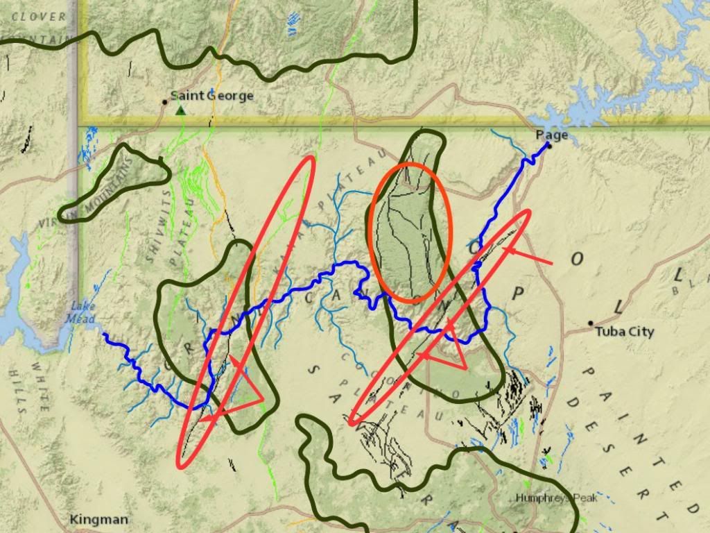
Message 1171: THEN tectonic force uplifted the region, and my favorite theory is that it cracked the uppermost strata (equivalent to the Claron or Brians Head of the Grand Staircase), into which the Flood waters then poured, collapsing the upper strata and excavating and widening the cracks. We are well aware of your crack hypothesis Faith. We just have trouble matching it up to reality and empirical evidence. Here is a map of the area again, and this time I have drawn ovals around the fault lines that exist near the canyon:
The black lines are the oldest fault lines, green, orange and lt blue are younger. On the right is a long oval and three arrows pointing to the fault lines that cross the ridge through the Kaibab Plateau ... So why doesn't the canyon follow this path, even when it crosses the river in two locations? On the left is a long oval and two arrows pointing to the fault lines that cross the western mounded area ... So why doesn't the canyon follow this path ... even when it is right at the edge of the canyon in one place and crosses it in another? The larger oval shows a lot of north\south cracks that didn't become canyons and some east\west ones that didn't become canyons ... So why isn't there a second canyon in the east\west crack line? My conclusion is that the cracks were there, alright, but that they were not followed by the canyon OR the river, they had NO effect on the location of the river and canyon. There are lots of cracks in that area, a lot more than would be expected in an undisturbed basin without tectonic cause. Here we have uplift, and there are cracks ... just not where you envisage them. Edited by RAZD, : black Edited by RAZD, : piclinkby our ability to understand Rebel☮American☆Zen☯Deist ... to learn ... to think ... to live ... to laugh ... to share. Join the effort to solve medical problems, AIDS/HIV, Cancer and more with Team EvC! (click)
|
|||||||||||||||||||||||||||||||||||||||||||
|
RAZD Member (Idle past 1435 days) Posts: 20714 From: the other end of the sidewalk Joined: |
How do I know I'm right? You can figure the timing from the genealogies. You don't have to reinterpret anything, it's all right there. How long did they live? How does the last mention in geneologies fit to historical information? by our ability to understand Rebel American Zen Deist ... to learn ... to think ... to live ... to laugh ... to share. Join the effort to solve medical problems, AIDS/HIV, Cancer and more with Team EvC! (click)
|
|||||||||||||||||||||||||||||||||||||||||||
|
RAZD Member (Idle past 1435 days) Posts: 20714 From: the other end of the sidewalk Joined: |
... but the Seth line all lived over 900 years I think, maybe a couple in their 800s ... And your evidence for this is ... ? Archaeological evidence has not discovered a single person that lived over 80 years (if they even lived that long) -- so if long life was common, why are there no fossils of people of such age?
I simply keep in mind that it's been about 4350 years since the Flood to our time. And I'm never quite sure about that number either but I think it's in the ballpark. It's just that my memory isn't so hot, so I have to look everything up and unless I know I'm off by a large amount there's no point, I'll just forget it again. So you take Bishop Usher as correct? BTW -- there are three trees in the White Mountains of California that are older than 4350 years ... http://www.rmtrr.org/oldlist.htm
quote: How did that happen? Edited by RAZD, : ...by our ability to understand Rebel American Zen Deist ... to learn ... to think ... to live ... to laugh ... to share. Join the effort to solve medical problems, AIDS/HIV, Cancer and more with Team EvC! (click)
|
|||||||||||||||||||||||||||||||||||||||||||
|
RAZD Member (Idle past 1435 days) Posts: 20714 From: the other end of the sidewalk Joined: |
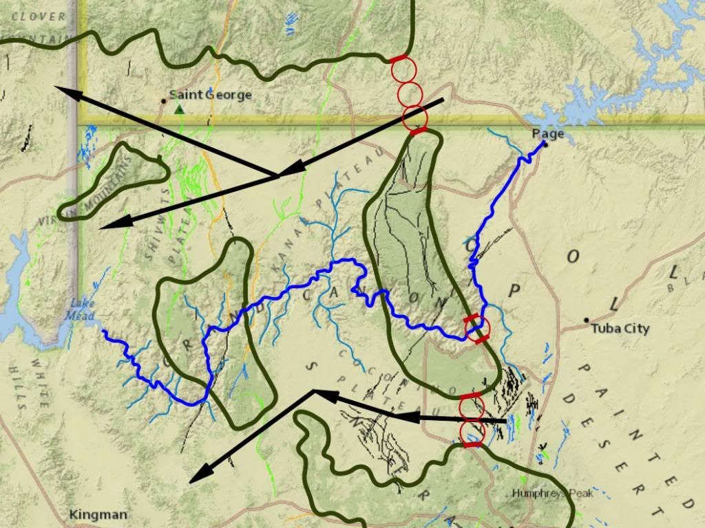
So Faith, you have two major problems with the Grand Canyon that you just have not answered.
Here are the pictures again:
You claim that the waters filled the canyon when it was carving it out, and you claim that the uplift caused cracks that then allowed the water to flow -- this does not fit either map shown above for the reasons given above. Your hypothesis fails to explain the evidence seen. Badly. The Palouse River shows both catastrophic channel flow erosion AND a place where this flood flow followed a fault line. The canyon there is not like the Grand Canyon ... why do you suppose that is? Edited by RAZD, : "" Edited by RAZD, : . Edited by Admin, : Narrow the images. Edited by RAZD, : pixlinkby our ability to understand Rebel☮American☆Zen☯Deist ... to learn ... to think ... to live ... to laugh ... to share. Join the effort to solve medical problems, AIDS/HIV, Cancer and more with Team EvC! (click)
|
|||||||||||||||||||||||||||||||||||||||||||
|
RAZD Member (Idle past 1435 days) Posts: 20714 From: the other end of the sidewalk Joined: |
Unfortunately it's not all that abnormal ...
... now flat earthers and climate deniers ...  by our ability to understand Rebel American Zen Deist ... to learn ... to think ... to live ... to laugh ... to share. Join the effort to solve medical problems, AIDS/HIV, Cancer and more with Team EvC! (click)
|
|||||||||||||||||||||||||||||||||||||||||||
|
RAZD Member (Idle past 1435 days) Posts: 20714 From: the other end of the sidewalk Joined: |
Have a good break ...
... and when you come back there is still this to consider:
Bottom line for a Biblical creationist is that we won't question the Bible, it's God's word, that's the way it is. You think that's stupid, of course, you think your science is right if it contradicts the word of God and that leads you to say some pretty insulting things about those of us who disagree. Unfortunately too many "Christians" have bought into it too, who ought to know better than to question God. The Bible is full of warnings about trusting man and rejecting God. Curiously, what I suggest is that you question the interpretation/s that leads you into these problems ... things that are not explicitly mentioned in the bible ... like the Grand Canyon.
It gets depressing having to deal with all the insults slung at creationists here, insults and refusal even to think about some of our arguments. There ARE some good arguments. Oh yes there are. But argument alone is not enough, you need an argument that is supported by the facts rather than contradicted by it. If the evidence of creation contradicts your interpretation then you have a choice: believe your god lied when s/he created the evidence or your interpretation is in error.
Anyway, I'm taking a break from this madhouse for a while. The other inmates will miss you. Edited by RAZD, : pixlinkby our ability to understand Rebel☮American☆Zen☯Deist ... to learn ... to think ... to live ... to laugh ... to share. Join the effort to solve medical problems, AIDS/HIV, Cancer and more with Team EvC! (click)
|
|||||||||||||||||||||||||||||||||||||||||||
|
RAZD Member (Idle past 1435 days) Posts: 20714 From: the other end of the sidewalk Joined: |
... I'd just like a little honesty from the OE side. Tell you what Faith, apply that honesty you talk about to these trees: http://www.rmtrr.org/oldlist.htm
quote: There are also dead Bristlecone pines, some still standing that have over 7000 tree rings, still preserved by the high and dry climate at the top of these mountains. We don't know from just looking at them when they died: it could be 50 years ago (minimum - they were found in 1960) or 100 years ago ... ... there is also a lot of dead wood lying on the ground. This wood would have floated away if there had been a flood. The living trees, the standing dead trees and the pieces of dead lying on the ground wood can be measured, and the pattern of ring thickness with ring count determined ... Applying the basic process of scientific information gathering we can count the rings in these living trees, the standing dead trees and pieces of dead wood lying on the ground, and measure the thicknesses of the rings in them, to determine the patterns of ring thickness as a function of ring count, and then to compare these patterns for each of the three living trees and the dead standing trees and the dead wood lying on the ground ... and by this process determine when these dead lying on the ground pieces fit into the chronology by matching their patterns with the three living trees and the dead standing trees ... ... and when we do this, the pieces fit into a chronology that overlaps the rings from the living trees and the dead standing trees and other pieces of dead lying on the ground wood with plenty of overlap and plenty of corroboration from other pieces also matching for the same ring count... so the tree ring count reaches back to 6,700 BCE, or 8,714 years into the past (2014)... This is honesty Faith, accepting the evidence of an old earth starts with measurements you can make of tree rings.
... I'd just like a little honesty from the OE side. and you can apply that honesty to answering these questions repeated again in Message 1292:
... I'd just like a little honesty from the OE side. All I ask is that you be honest in admitting that you are making stuff up, but I'm not asking you to be honest with us so much, Faith, but to be honest with yourself. The earth is old, Faith, very very old. The evidence of an old earth all points to the same results time and again, just like the trees - different methods agree on the same results. Edited by RAZD, : pixlinkby our ability to understand Rebel☮American☆Zen☯Deist ... to learn ... to think ... to live ... to laugh ... to share. Join the effort to solve medical problems, AIDS/HIV, Cancer and more with Team EvC! (click)
|
|||||||||||||||||||||||||||||||||||||||||||
|
RAZD Member (Idle past 1435 days) Posts: 20714 From: the other end of the sidewalk Joined: |
I'm busy elsewhere RAZD but I have answered your challenges already: ... You are not being honest with yourself. You have made up silly excuses not to pursue evidence to a logical conclusion.
... the tree rings are counted from a uniformitarian point of view, they need to be counted from a Floodist perspective and I am not in a position to do that at the moment. ... Actually the count is based on variations in climate from year to year affecting the growth of the trees, some years good (thick rings) and some years bad (thin rings) and some years in between. As climate is observed, then any change in climate would be evident in the rings. There is no indication of substantial difference from one year to the next. The climate there is high, dry and cool. Due to the elevation the growing season is short and the moisture comes from "spring" - July - melting snow and rain and 40 days of rain would be an extraordinary year for growth. The data is available for review.
... and I am not in a position to do that at the moment. ... Nor will you ever be. There is no "Floodist perspective" that looks at the data honestly and concludes that one year the flood happened, because there is no substantial change in the growth patterns from those of the high dry cool climate.
Bottom line: your count disagrees with God's word, end of subject. No, it shows that your interpretation disagrees with God's work.
As for that map you keep posting, I'm waiting for you to acknowledge that it poses AT LEAST as much of a problem for the river explanation as for the Flood explanation, and eventually I may, or may not, have more to say about the Flood explanation. Well Faith, I'll be honest and tell you that it doesn't pose a problem for the river erosion explanation, not in any way. The uplift occurred, lifting the whole plain out of the shallow sea that had covered it, the river formed on that flat plain, which is why it meanders, at the west end there was a large drop off at the boundary to the uplifting and that caused substantial erosion there, erosion that worked its way upstream, and the canyon became incised, but the uplift continued to occur, so the walls of the canyon are lifted as the river cuts deeper. Evidence for this is in the side streams, especially Kanab Creek to the north and Meadow Creek to the south, creeks that are tributary to the Colorado even though the land they pass through rises to the rims of the canyon. Water does not flow uphill, Faith, nor are tributaries formed perpendicular to mass drainage flows. The uplift is still occurring and can be measured, has been measured, and the rate of uplift is consistent with the formation of the canyon by this evidence. That continued uplift is why the rims of the canyon are higher than the north and south passes, and that explains why there are no water channel erosion patterns of any kind across those passes, and it explains Kanab and Meadow creek canyons cutting down to maintain their flow to the Colorado river.
Fault lines are not the only cracks that would have occurred, ... Cracks like mud cracks don't form canyons, and cracks of any great depth would be fault lines.
... in fact earthquakes that caused the fault lines would no doubt have created all kinds of cracks in the uppermost strata due to the curvature of the uplift which is apparent on those cross sections. ... Earthquakes occur along fault lines, and don't produce crossing fault lines. But Faith, you are ignoring the fault lines that cross the canyon in the direction of general flow of the river. Why did those fault line cracks not become the path of the canyon if it was formed by cracks? Especially the one at the Kaibab Plateau that crosses a major meander of the river making a much shorter path? The black fault lines are >1.6 million years old ...
We're ALL "making up stuff," that's what YOU ALL need to acknowledge, ... We look at the evidence, ALL the evidence, and form hypothesis that explain the evidence in a manner consistent not only with all the evidence but consistent with the known behavior of water, sand, mud and rock materials, and consistent with the known age of different formations. This isn't just making stuff up, Faith, it is developing an informed, educated, consistent model that can be tested. As in the sandbox test from Coragyps.
... , that was the point I was making about the ad hoc theorizing being done by Percy and Dr. A. We ALL have the same evidence at hand, and we all have the task of explaining it for our biased point of view as well as we can. And YES, that is all YOU are doing too. Faith, please pause and think: what would a completely unbiased point of view do with this evidence? Do you follow the evidence wherever it leads ... or do you invent some restriction out of the blue to constrain your investigation/s? Why would an unbiased point of view invent any restrictions -- what purpose would that serve? Would they be more or less likely to reach a valid conclusion with the invented restriction or without it? Be honest Faith. How would an open-minded skeptic approach the evidence? by our ability to understand Rebel American Zen Deist ... to learn ... to think ... to live ... to laugh ... to share. Join the effort to solve medical problems, AIDS/HIV, Cancer and more with Team EvC! (click)
|
|||||||||||||||||||||||||||||||||||||||||||
|
RAZD Member (Idle past 1435 days) Posts: 20714 From: the other end of the sidewalk Joined:
|
Textus Receptus Only, King James for now until they do an updated KJ from the TR. It's the only trustworthy English translation. I have a whole blog on the subject, The Great Bible Hoax of 1881 if you'd care to peruse it. Can't WAIT for your gracious and enthusiastic acceptance. Your interpretation of human interpretation. What bible did Bishop Usher use? by our ability to understand Rebel American Zen Deist ... to learn ... to think ... to live ... to laugh ... to share. Join the effort to solve medical problems, AIDS/HIV, Cancer and more with Team EvC! (click)
|
|||||||||||||||||||||||||||||||||||||||||||
|
RAZD Member (Idle past 1435 days) Posts: 20714 From: the other end of the sidewalk Joined: |
You know, the proper attitude in a debate is that you deal with the arguments as they come up and refrain from psychoanalyzing your opponent. All I'm asking for is honesty Faith. by our ability to understand Rebel American Zen Deist ... to learn ... to think ... to live ... to laugh ... to share. Join the effort to solve medical problems, AIDS/HIV, Cancer and more with Team EvC! (click)
|
|||||||||||||||||||||||||||||||||||||||||||
|
RAZD Member (Idle past 1435 days) Posts: 20714 From: the other end of the sidewalk Joined: |
EVERYTHING is "human interpretation" when it comes down to it at the level you are using it so why bother to mention it? There is still the question of which interpretation is the correct one and of course I make the case for my own at my blog. You could consider the evidence before you make your judgment. Isn't that what you all think we're supposed to do anyway? Not really Faith. Objective evidence is objective evidence, and what you are talking about is subjective -- the interpretation of the bible differs from person to person, and that is because it is subjective.
Bishop Ussher was born about thirty years before the King James Bible was produced so I would assume he used the Tyndale or the Geneva which were its precursors, or perhaps he switched to the King James when it came out. It is something like 95% from the Tyndale Bible anyway. That is your subjective evaluation, complete with your personal bias (assuming it will support you) Tree rings on the other hand are objective evidence -- you and I can both touch these and count the tree rings and there is only one sum total you can reasonably reach without making stuff up. What the dendrochronologies accomplish is actually the least ancient counting possible because it allows overlaps. If you don't allow the overlaps then the chronology gets longer, goes deeper into the past. For instance without overlaps the 7000 year old dead standing trees would then be placed before the beginning of the living trees, and it is rather unreasonable to think these trees have been standing dead for over 5,000 years. They cannot make shorter chronologies unless you violate the matching process, and this means ignoring the overwhelming matches between all the living trees and the dead standing trees. And then it is no longer an objective approach, nor is it science nor is it even an "interpretation" because denial is not interpretation. Nor is denial a subjective evaluation: either they do match or they do not match. This matching can be done by computers. This data collection and documentation is fundamentally different from subjective interpretation, and you apparently have no idea how strong this information is, how many pieces of wood show the same overlapped pattern of thicknesses, or how well those patterns match from piece to piece. by our ability to understand Rebel American Zen Deist ... to learn ... to think ... to live ... to laugh ... to share. Join the effort to solve medical problems, AIDS/HIV, Cancer and more with Team EvC! (click)
|
|||||||||||||||||||||||||||||||||||||||||||
|
|
Do Nothing Button
Copyright 2001-2023 by EvC Forum, All Rights Reserved
![]() ™ Version 4.2
™ Version 4.2
Innovative software from Qwixotic © 2024


 (1)
(1)