|

Understanding through Discussion |
|
|
Register | Sign In |
|
QuickSearch
| Thread ▼ Details |
|
Thread Info
|
|
|
| Author | Topic: Earth science curriculum tailored to fit wavering fundamentalists | |||||||||||||||||||||||||||||||||||||||||||
|
edge Member (Idle past 1736 days)  Posts: 4696 From: Colorado, USA Joined:
|
Have you ever noticed these things, they're called mountains?
I'm still trying to get someone to explain where the sediments come from in the middle of a global flood... Can you figure out where the sediment is coming from? I'm also trying to figure out where Noah lived. These days we live on an erosional unconformity. If Noah lived on land, then there must have been erosion going on. But Faith says all erosion has occurred after the flood. I'll keep everyone posted with whatever I find out.
|
|||||||||||||||||||||||||||||||||||||||||||
|
edge Member (Idle past 1736 days) Posts: 4696 From: Colorado, USA Joined:
|
No, what Faith says is that there is no" erosion" within the geologic column that deserves to be compared with the massive erosion of the surface we now live on, ...
Do you have any idea what the end result of erosion is? Can you tell us how the thick sandstones of the Mesozoic formed in the middle of your flood if there was no erosion occurring in the middle of the geological time scale?
... and that fact proves the stack does not represent former time periods.
But if it's not a fact? And please explain your reasoning here. Not seeing it.
The erosion in Noah's time contributed the sediments that formed the geologic column in the Flood of course.
But where did the mountains come from in Noah's time? After all there was no tectonism before the flood either...
|
|||||||||||||||||||||||||||||||||||||||||||
|
edge Member (Idle past 1736 days) Posts: 4696 From: Colorado, USA Joined: |
Okey dokey. Mountains eh. Source of sediment for the rock slabs that represent entire worldwide landscapes with flora and fauna that last hundreds of millions of years, eh?
Why not? How long should they last?
|
|||||||||||||||||||||||||||||||||||||||||||
|
edge Member (Idle past 1736 days) Posts: 4696 From: Colorado, USA Joined:
|
I'm just trying to understand how all those time periods supposedly with the same kind iof topography we have today, got compressed into neat flat packages of rock of particular kinds of sediment, and where the stuff needed to form the next landscape with similar topography could come from.
Maybe because in one place you are looking at deposition and in another you are looking at erosion. For instance outside my window are mountains, but less than a continent away there are nice gently sloping continental shelves with limestone being deposited... Probably makes no sense, eh?
|
|||||||||||||||||||||||||||||||||||||||||||
|
edge Member (Idle past 1736 days) Posts: 4696 From: Colorado, USA Joined: |
It's easy to say No No No we don't believe that, but how about you describe exactly how it DID happen then? How do you get a new topographically varied landscape to form on top of a slab of rock that represents the previous supposedly topograqphically varied landscape?
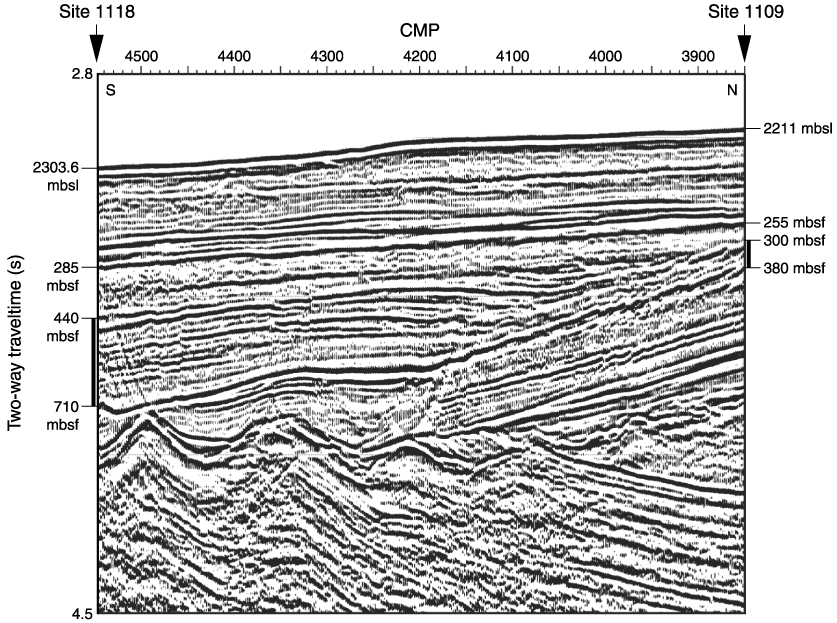
Perhaps by filling in the low spots in the landscape? Maybe this image of a seismic cross-section will help.
|
|||||||||||||||||||||||||||||||||||||||||||
|
edge Member (Idle past 1736 days) Posts: 4696 From: Colorado, USA Joined: |
Didn't I show you maps of underground cave systems contrasted with sub-aerial erosional channels? There really is no comparison between the two - except they are both carved by water.
You're way ahead of me. I'm still trying to figure out what an underground canyon is...
|
|||||||||||||||||||||||||||||||||||||||||||
|
edge Member (Idle past 1736 days) Posts: 4696 From: Colorado, USA Joined:
|
We're trying to explain how anything like the entire current surface of the earth, massively eroded massive geological structures of various kinds of rocks and sediments, could ever have existed for hundreds of millions of years ...
That's the point. They didn't.
... of previous time periods, ...
What's the problem with previous time periods?
... how the mountains grew up and then collapsed down and valleys filled in until the whole shebang wrapped up into a slab of rock that spanned an entire continent, ...
I'm not seeing the problem. How widespread should a geological formation be? Can you tell me about a formation that spans an entire continent?
... and how that scenario got repeated time and time again to create the entire Geologic Column ...
Did you ever hear of geologic time?
... and you think your seismic picture says anything at all about that?
It shows pre-existing topography being filled in by sedimentation. The upper layers are flat. As you wish. And who is 'we'? Edited by edge, : No reason given.
|
|||||||||||||||||||||||||||||||||||||||||||
|
edge Member (Idle past 1736 days) Posts: 4696 From: Colorado, USA Joined: |
That's a pathetic joke. The strata span entire continents and you've got them building up in a river valley and even leaving the landscape intact around them.
Please give an example of such a formation that spans a continent.
|
|||||||||||||||||||||||||||||||||||||||||||
|
edge Member (Idle past 1736 days) Posts: 4696 From: Colorado, USA Joined:
|
About continent spanning strata, strata really only span the region of a homogenous depositional environment, which isn't static but can move around (for example, a coastline (which can represent as many as three adjacent homogenous depositional environments: sand, shale and limestone) will move back and forth as sea levels rise and fall). A stratigraphic layer could span a continent, but one wouldn't expect it to be common.
This is exactly correct. It is rare for a single depositional environment to exist over a broad (continental scale) area at one time. An example would be he Cretaceous Chalk deposits of western Europe. The basal Cambrian sandstone formations might be another example, but the fact is that these are beach sands which require (guess what) emergent land masses and erosion. However, some of the most widespread deposits that we know of such as the Navajo Sandstone of the western United States have no lithological equivalent in other parts of the continent. There may be some chronological equivalents, but there are no great ergs in almost any direction. I guess that, basically, what I'm saying is that things are a lot more complex than the common YEC understanding of large scale sedimentation.
|
|||||||||||||||||||||||||||||||||||||||||||
|
edge Member (Idle past 1736 days) Posts: 4696 From: Colorado, USA Joined: |
Could we draw a parallel between the Najavo Sandstone and today's sandhills in Nebraska as an example of geology in action. Not too long ago the Nebraska Sandhills were a living erg but now there are grasses growing which may preserve the underlying formations so they someday become sandstone?
Certainly could. They are different ages, of course. I'm not sure about how large or thick the sand hills are, but if they don't erode away, they will form a desert sand deposit in the current geological record. Or if Faith is correct, the geological record is dead and nothing will change, ever...
|
|||||||||||||||||||||||||||||||||||||||||||
|
edge Member (Idle past 1736 days) Posts: 4696 From: Colorado, USA Joined:
|
Is there an answer to my question about how thick shale layers great in extent form?
They typically form in basins or on wide continental platforms that are inundated for extended periods. The Manco Shale is one of the large ones that I am familiar with and it formed on the bottom of the Cretaceous seaway in central North America over a period of about 15 million years. Here is a stratigraphic correlation chart for the Mancos.
What it shows is the Mancos Shale, and its equivalent, the Pierre Shale, in gray, do not extend to the west where the Laramide mountain building event was occurring. In yellow, 'tongues' of sand stone such as the Dakota up to the Fox Hills extend from source areas in the highlands to the west, eastward into the Mancos basin. These represent times of marine regression as sea levels fluctuated during the time of the seaway. Just for fun, here is a cross section of the Denver Basin sequence which is underlain by the Pierre Shale.
AFAIK, the Pierre is eroded away east of the Dakotas. Not sure if this answers you question, but these are truly important geological features of the planet. Edited by edge, : No reason given.
|
|||||||||||||||||||||||||||||||||||||||||||
|
edge Member (Idle past 1736 days) Posts: 4696 From: Colorado, USA Joined: |
While SO may people contributed and continue to contribute to my knowledge regarding the basics of geology, I want to especially thank Dr. Adequate and Edge for their patience and sharing. The online ebook from Dr. Adequate was a particularly valuable resource.
You are welcome.
|
|||||||||||||||||||||||||||||||||||||||||||
|
edge Member (Idle past 1736 days) Posts: 4696 From: Colorado, USA Joined:
|
So when a shale layer is great in extent it implies an underlying wide continental shelf, such as the one off our east coast?
Well, it's a fairly complex picture, but basically yes. Most of the deposits I'm familiar with are continental basins with some enclosure.
The continental runoff suspended in the water that makes up shale deposits doesn't just disappear at the edge of the continental shelf, where the depth increases rapidly. What do deep water shale deposits look like?
The deep sea deposits usually exist primarily in the sea. That sounds kind of moronic, but what I mean is that they are often incorporated into the rock record as highly deformed and accreted to the continent, or they are subducted. An exception would be something like the Gulf of Mexico, where huge accumulations of mud will someday become an epic mudstone (shale) basin. Depending on the course of plate tectonics it could also be deformed. Another case where they are not subducted is in the Great Basin where they have been overthrust onto the slope and shelf rocks. In that location, they are called the Western Assemblage or the Upper Plate rocks, etc. But, they are different in having a lot more chemical sediments such as cherts, along with turbidites and oceanic volcanics associated with them. Here is what can happen to the deep sea sediments:
This is a passive margin or trailing continental margin such as the Atlantic side of NA.
Huge shale deposit could be built out onto the oceanic crust as in the Gulf. I hope this helps in some small way. The message board environment isn't the best for explaining such broad and variable topics.
|
|||||||||||||||||||||||||||||||||||||||||||
|
edge Member (Idle past 1736 days) Posts: 4696 From: Colorado, USA Joined: |
But Edge pointed out that shale deposits can occur hundreds of miles from shore so that not only do you get the pattern above, you also get a thick shale layer of great extent, as shown in this diagram with the tongues of shale and sandstone intertwined at the left margin of the Marcos Shale:
The jagged edges of the shale environment in the schematic cross section can represent two things: -- transgression-regression-- a transitional boundary too detailed to show on the diagram In this case the major departures are certainly related to transgression and regression of the basin. In fact, you can see that one of the major transgressions resulted in the Fort Hayes Limestone out in the middle of the basin. But yes, the thicker shale systems are long-lived and more stable than, say, the cyclical transgressions that gave us the Carboniferous coal sequences on the east coast.
|
|||||||||||||||||||||||||||||||||||||||||||
|
edge Member (Idle past 1736 days) Posts: 4696 From: Colorado, USA Joined: |
Now I understand that it would actually be physically impossible for the entire geologic column to exist everywhere under our feet - materials are being moved around in front of our eyes daily. But just so I can say for sure whether it does or does not exist *anywhere* (typical creationist claim that is does not), I have been investigating. Not sure why this claim matters so much to them, but whatever.
I see no reason why it could not exist in these locations. At the same time, I see no reason why it would necessarily exist anywhere on the planet. However, the point is that it does exist despite YEC claims. This is really a YEC red-herring claim.
Can anyone vouch for the information in this TalkOrigins page, or suggest another source.
The people who can vouch for it would be those in the oil and gas field such as Glenn Morton. However, as you mentioned, this seems to be important to YECs and unimportant to geologists. It appears to simply be an argument propogated through the literature, having little or no significance. The other point is that they are wrong.
|
|||||||||||||||||||||||||||||||||||||||||||
|
|
Do Nothing Button
Copyright 2001-2023 by EvC Forum, All Rights Reserved
![]() ™ Version 4.2
™ Version 4.2
Innovative software from Qwixotic © 2024
 (1)
(1)