|

Understanding through Discussion |
|
|
Register | Sign In |
|
QuickSearch
| EvC Forum active members: 65 (9164 total) |
|
| |
| ChatGPT | |
| Total: 916,904 Year: 4,161/9,624 Month: 1,032/974 Week: 359/286 Day: 2/13 Hour: 1/1 |
Summations Only | Thread ▼ Details |
|
Thread Info
|
|
|
| Author | Topic: Why the Flood Never Happened | ||||||||||||||||||||||||||||||||||||||||||||
|
PaulK Member Posts: 17828 Joined: Member Rating: 2.3
|
quote: I'm pretty sure that you're wrong about the OE view - that states that the meanders are early and are cut by the river continuing to follow the same course as it cuts down. In any version where the canyon forms before the meanders you have the difficulty of how the meanders get cut - and where's the evidence for it? Where's the original canyon, for one? And if the meanders could be cut that deep over time, without the initial surge, why not the rest of the canyon?
quote: You're not making a lot of sense here. IN the OE view as I understand it, the River and it,s meanders existed before the uplift. When the uplift started the river eroded downwards, keeping it's original course. The meanders got their depth the same way as the rest of the canyon. So I guess the problem is just your assumption that the meanders are relatively recent.
quote: I guess you're still missing the point that the river bed has cut down at the same rate as the uplift has raised the land around it - in a sense the river bed hasn't moved at all.(The downward erosion is a response to the uplift, which makes sense when you think about it. ) quote: No, you"re simply wrong about the mainstream view.
quote: The river exists before the uplift. The slope is produced by the uplift. Therefore the river is established before there is any slope to worry about. That seems obvious to me.
|
||||||||||||||||||||||||||||||||||||||||||||
|
JonF Member (Idle past 197 days) Posts: 6174 Joined: |
Paul, you've got things seriously out of order here. The meanders occur at the very end of the carving of the canyon, whether on OE theory or YEC theory.
Nope, the OE view is that the meanders were formed before the uplift and were cut as incised meanders. They are quite common, here's an image search. {ABE}The graded river and base level. Incised meanders with near vertical sides can only be cut in hard rock (soft sediments would slump to lower angles as at the Toutle river at Mt. St. Helens), and by water that isn't moving too fast (otherwise the upstream inner edge and downstream outer edge would be severely undercut by the forces involved in changing the direction of the water suddenly). Edited by JonF, : No reason given.
|
||||||||||||||||||||||||||||||||||||||||||||
|
Percy Member  Posts: 22504 From: New Hampshire Joined: Member Rating: 4.9 |
PaulK writes: Provided the bending is done incredibly slowly, under high pressure, yes. There is good evidence (distorted fossils) of such things happening elsewhere. You and Faith might be talking about different bending than I am. The bending I'm talking about is in the middle of this diagram just above the supergroup:
The diagram isn't to scale. It ranges across hundreds of miles horizontally and only a few miles vertically, so the bending is very exaggerated. In reality the radius of the bending is hundreds of miles. There would be no detectable distortion of fossils or anything else. When you mentioned distorted fossils it seemed to me that you might be talking about some relatively tight bending. --Percy
|
||||||||||||||||||||||||||||||||||||||||||||
|
RAZD Member (Idle past 1434 days)  Posts: 20714 From: the other end of the sidewalk Joined:
|
PPT – Floodplain Management SESSION 7 PowerPoint presentation | free to view - id: 3cd141-N2FhZ
Can't picture what you have in mind here, but a river already established would divert AROUND any uplifting of land, not erode through it, ... Not if the uplift were less than the banks of the river at any time in the process. Even tributaries to the river would have their own riverbanks.
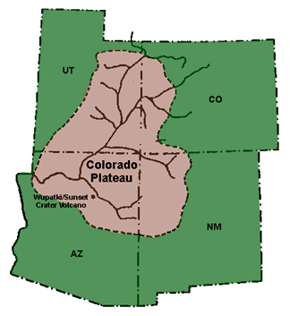
... and besides, this mounded uplift has a north-south slope, ... When you look at cross-sections that is what you see, but there is also a strong east to west slope component. The uplift covers a large area: Colorado Plateau - Wikipedia
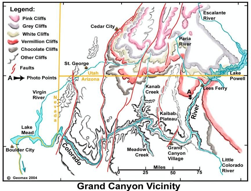
quote: ... so it's hard to see how water could have eroded the mound east to west. ... There are several things here: first the "mound" is much wider than high -- the sections show expanded vertical scale so it looks steeper than it really is -- so the slope even today would not be that great. Second that when the uplift started it would not have the slope it has today, and would not be enough to move the river out of its riverbed. Third, the tributary area and streams were also being lifted so the pattern of drainage would not be altered appreciably - water would continue to flow to the tributaries and the main river. This is a downloadable powerpoint slide show with a lot of general information as well as two pictures pertinent here -- slides 12 and 13:
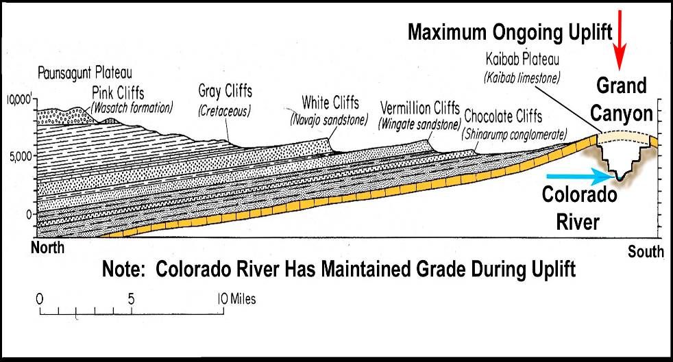
quote: Slide 12 shows the general topography today with the staircase cliffs and ~flat areas in between. Slide 13 shows a cross-section, with vertical scale ~3.5 x horizontal scale, and it shows erosion of the area north of the canyon so that the current surface is relatively flat ... note that the maximum north south uplift is actually at the canyon ... but that it says the "Colorado river has maintained grade during uplift" This USGS PDF topomap shows essentially the same topography in greater detail.
... so it's hard to see how water could have eroded the mound east to west. There is apparently an east-west slope down through the canyon now that the river runs down, but the question is how it could have cut in a westerly direction through the upper part of the uplift at all in the first place, right when the uplift was occurring. Because the process was gradual and spread out, the whole area was being uplifted so the river that was already there would be able to maintain its course, cutting deeper where the grade of the river increased, less where the slope decreased and this would increase the erosion from west to east along the existing river. Notice that there are large scale meanders as well as the small scale meanders noted previously -- a flow pattern that is not consistent with rapid flow or erosion.
I'm not sure what rapid runoff you have in mind but if you are referring to my idea that a huge amount of water had to have carved the canyon, I don't explain the meanders or switchbacks as being caused by that initial cataract of water, but by the river that resulted after the great volume of water had decreased to river size. ... If a "huge amount of water ... carved the canyon" then the flow would be linear and downslope, a pattern that you argue for the river to take, and which cannot be accounted for by comparing the actual course to the uplifted uncut area. Your own argument goes against your proposed formation sequence.
... , I don't explain the meanders or switchbacks as being caused by that initial cataract of water, but by the river that resulted after the great volume of water had decreased to river size. ... But the WHOLE canyon meanders, Faith, look at it:
... It is rivers that create those formations, not great cataracts of the size I've had in mind that opened the canyon in the first place ... Exactly, which is why the pattern of the whole canyon should be linear for your proposed process and why this is invalidated by the actual pattern of the whole canyon meandering -- demonstrating that it is a result of slow river erosion, not rapid cataract erosion. Notice the rivers north and south of the canyon that are still tributary to it -- Kanab Creek and Meadow Creek in particular -- they have not been cut off by the uplift, and they too have cut deep into rock to maintain their gradients and their flow to the Colorado. This pattern of watershed erosion cannot happen with your scenario for the formation of the canyon, as you would need water to flow uphill.
... I picture that flowing in from all sides of the canyon, not just the eastern end, ... So it would flow uphill to the top of the uplifted area and then west along a ridge?
... but there is clearly enough of an east-west slope for the river to run down now. There is clearly a pattern of river erosion along the whole length, width and depth of the Grand Canyon and the tributary streams and rivers.
But if you are picturing the river on a flood plain before the canyon existed at all, and attribute the cutting of the canyon to the river's erosive effects as the uplift was occurring, this doesn't seem possible, since the uplift into which the canyon cut is this mounded east-west sausage shape,... You keep forgetting that the initial uplift would not be that great, each year the rise would not challenge the river enough to stop the river so it would continue to flow and erode where it flowed ... this would be no different than the river cutting through the lava dams except that the uplift would be much slower than the deposition of lava.
... not to mention that a river would go around any kind of uplift, not through it. So you need an explanation for how that river made its way along the line of the canyon at all, since the slope of the mound where the canyon now is, runs south, not west. Time, Faith, a long time of slow uplift -- on the order of millimeters a year.
By the way I just drew a rather klutzy diagram of what I'm trying to describe, and posted it at my blog (not sure how to post it here) which is HERE .
Which, not surprisingly, does not match the topology around the canyon.
But again, the uplift appears to be in a mound shape sloping north to south, in a sort of sausage shape that extends at least some great part of the length of the canyon east to west, yet the canyon is cut east to west through the south side of the slope, where as I said it looks to me like the water would INTIALLY have had to run south, not west. And this is why your scenario doesn't work. What works is gradual uplift and flow along an existing river that cuts deeper over time as the land rises. Enjoy. Edited by RAZD, : tributaries Edited by RAZD, : added slide 12 and 13 images Edited by RAZD, : slideshow link updatedby our ability to understand Rebel☮American☆Zen☯Deist ... to learn ... to think ... to live ... to laugh ... to share. Join the effort to solve medical problems, AIDS/HIV, Cancer and more with Team EvC! (click)
|
||||||||||||||||||||||||||||||||||||||||||||
|
Percy Member Posts: 22504 From: New Hampshire Joined: Member Rating: 4.9
|
Faith writes: Yes, that could work I suppose. Plausible enough based on your OE assumptions, considering that we're all guessing. Downcutting through an uplifting landscape is a frequently observed process in river systems all around the world. Here's a rough diagram I created illustrating the process:
Each line represents the same landscape thousands of years apart. On the top line we see a river cut into the landscape. We're seeing the river edge on. On the next line we see the landscape has uplifted slightly, and the river has eroded down into it and followed the same course. On the third line down we see that the landscape has continued to gradually uplift, and during this uplift the river has continued to gradually erode down into the underlying strata. On the forth line down the landscape has continued to be gradually uplifted to what is at this point a significant amount, and the river has continued to gradually erode down into the underlying strata to form a canyon. And on the bottom line the landscape has again continued to be gradually uplifted to what is now a tremendous amount, and the river has continued to gradually erode into the underlying strata to form a great canyon. --Percy Edited by Percy, : Grammar.
|
||||||||||||||||||||||||||||||||||||||||||||
|
Dr Adequate Member (Idle past 314 days)  Posts: 16113 Joined:
|
Well, have a look at this rather schematic block diagram.
In picture 1, the river is flowing merrily away. In picture 2, a little uplift has occurred. Uplift is slow, it's not likely to be so much as to divert the river, so it goes on flowing through the same channel. Only now there's a bump in the river just at the point at which it gets faster ('cos it's shallower). This is to erosion what a red rag is to a bull, and so we get figure 3, where the bump has been eroded away and the river has constant depth again. Repeat this process a few hundred times, and you get a river flowing into a deep canyon, and a bunch of creationists going about reciting the Creationists' Creed: "I don't understand this. Therefore no-one understands this. Therefore I understand this perfectly: it happened by magic."
|
||||||||||||||||||||||||||||||||||||||||||||
Faith  Suspended Member (Idle past 1474 days)  Posts: 35298 From: Nevada, USA Joined: |
That depends on the river's already flowing before the canyon existed at all, in the direction you expect it to end up in the eventual canyon it's supposedly already begun to cut, and before the uplift even got started. It also depends on its already having a nicely barricaded channel to flow in that would keep it from flowing south if the channel is flowing east-west, and if you have any evidence that it WAS already flowing east to west in such a nicely walled channel before the uplift occurred you've got a point. But of course it's all made up as all this stuff is. Very convenient that the uplift just happened to rise exactly where the channel was flowing along the southern side of that eventual mound where the canyon eventually developed. I wonder how that happened?
Edited by Faith, : No reason given. Edited by Faith, : No reason given.
|
||||||||||||||||||||||||||||||||||||||||||||
|
Faith Suspended Member (Idle past 1474 days) Posts: 35298 From: Nevada, USA Joined: |
Funny how uplifts seem to like to push themselves up right beneath a stream of water like that, that has already formed banks that prevent it from spilling down the slope of the mounded uplift, but hey, it's not impossible of course, just not very likely as a general rule.
Seems to me rivers aren't all that cooperative in reality. They change course rather frequently due to all kinds of changes in the environment, for instance, such as their own deposits building up to create barriers that redirect the flow among other things, but the Grand Canyon river was already flowing in exactly the direction of the canyon that eventually formed, didn't change direction in millions of years apparently, just cut relentlessly into the uplifting land, and the uplifting land, over 250 miles of mounding land, just happened to rise exactly beneath this already-flowing river, without disturbing its banks or its course and so on. Well, OK, if you believe that.
|
||||||||||||||||||||||||||||||||||||||||||||
|
PaulK Member Posts: 17828 Joined: Member Rating: 2.3
|
quote: If your only objection to the conventional explanation is that it assumes that there was a river right where the river is now then you really don't have much of an objection.
quote:I think that the fact that we DO have a river there is pretty good evidence. If you want to argue otherwise you need to do more than try to pretend it's just made up. quote: I don't see anything exact about it.
|
||||||||||||||||||||||||||||||||||||||||||||
|
Faith Suspended Member (Idle past 1474 days) Posts: 35298 From: Nevada, USA Joined: |
No, the canyon does not have to be linear in my scheme, I just didn't try to get the zigzags into the drawing, doing it straight was enough of a challenge.
Yes there would have to be an east-west slope component as I believe I already said, but we're talking about an uplift that MOUNDED with a strongly north-south slope but you somehow expect an east-west river to remain east-west under such circumstances just because it supposedly took millions of years.
Because the process was gradual and spread out, the whole area was being uplifted so the river that was already there would be able to maintain its course, cutting deeper where the grade of the river increased, less where the slope decreased and this would increase the erosion from west to east along the existing river. Right, enough to cut a canyon over 250 miles long and many miles wide and a mile deep into a mounding surface. Sure, RAZD. This is physically highly improbable if not totally impossible as I've already indicated in my latest posts. Rivers change course all the time in relation to changing topography, and topography changes a lot, but somehow you expect this river to keep flowing east west into a rising mound with north south slopes, just because you also think it all took millions of years. Ah well, that's the way it must have been then. I have no doubt you CAN rationalize your way out of this because as I've said many times all the interpretations of past events are just guesswork, interpretation, speculation, etc., we cannot KNOW any of this so if it suits your theory you can embrace even impossibilities. Edited by Faith, : No reason given.
|
||||||||||||||||||||||||||||||||||||||||||||
|
Faith Suspended Member (Idle past 1474 days) Posts: 35298 From: Nevada, USA Joined: |
Nope, the OE view is that the meanders were formed before the uplift and were cut as incised meanders. They are quite common, here's an image search. There coujldn't have been meanders in a river a mile deep in a canyon before there was a canyon, and Percy already agreed that the canyon was cut into the uplift. But of course you're free to disagree with him. Edited by Faith, : No reason given.
|
||||||||||||||||||||||||||||||||||||||||||||
|
Faith Suspended Member (Idle past 1474 days) Posts: 35298 From: Nevada, USA Joined: |
I'm pretty sure that you're wrong about the OE view - that states that the meanders are early and are cut by the river continuing to follow the same course as it cuts down. Rivers don't normally keep to a certain course even over a hundred years let alone millions and let alone keep meanders, that are created by differential deposition along their flow, keep it all going in a GENERAL east-west direction without losing its course, while the land is rising with a strong north-south slope into which it all somehow continues to keep its course even over millions of years and maintain it at the mile deep bottom of the very canyon it supposedly carved. . But anything is possible in human imagination strongly under the sway of a theory.
|
||||||||||||||||||||||||||||||||||||||||||||
|
Dr Adequate Member (Idle past 314 days) Posts: 16113 Joined: |
That depends on the river's already flowing before the canyon existed at all, in the direction you expect it to end up in the eventual canyon it's supposedly already begun to cut, and before the uplift even got started. It also depends on its already having a nicely barricaded channel to flow in that would keep it from flowing south if the channel is flowing east-west, and if you have any evidence that it WAS already flowing east to west in such a nicely walled channel before the uplift occurred you've got a point. But of course it's all made up as all this stuff is. Very convenient that the uplift just happened to rise exactly where the channel was flowing along the southern side of that eventual mound where the canyon eventually developed. I wonder how that happened? I can attach no meaning to this paragraph. Would you like to try again?
|
||||||||||||||||||||||||||||||||||||||||||||
|
Percy Member Posts: 22504 From: New Hampshire Joined: Member Rating: 4.9
|
Faith writes: That depends on the river's already flowing before the canyon existed at all,... The river formed the canyon, so by logical necessity it existed before the canyon.
...in the direction you expect it to end up in the eventual canyon it's supposedly already begun to cut, and before the uplift even got started. In the early stages of canyon formation, diversion of the river onto a different path is very likely. We know this because we see rivers changing their courses today, and geologists have found evidence all over the world of the changing paths taken by rivers. But as a river cuts more and more deeply into an uplifting landscape to form the beginnings of an actual canyon, diversion of the river out of the canyon becomes increasing unlikely. In this image of Mississippi River, the riverbanks are only slightly higher than the river, so the river can easily escape the banks and find another route, which geological history tells us it has done many times:
But in this image of the Amur River in Mongolia you can see that once a river has begun to cut down a little into a landscape, diversion onto another course is very unlikely:
It also depends on its already having a nicely barricaded channel to flow in that would keep it from flowing south if the channel is flowing east-west, and if you have any evidence that it WAS already flowing east to west in such a nicely walled channel before the uplift occurred you've got a point. You misunderstood Dr Adequate's diagram. First, it's not a "nicely walled channel". It's a diagram of a normal river made with a drawing tool using straight lines. Second, it doesn't show a canyon, nor was it intended to. It's an illustration of what happens to a normal river when it experiences just a tiny bit of uplift. In case it's not clear, the river should be interpreted as flowing up out of the page.
But of course it's all made up as all this stuff is. None of this is made up. Geologists go out in the field and observe this behavior, and they study it in the lab both with computers and with models like this:
A model like this can quickly illustrate flowing water's ability to quickly erode through a region of mild uplift. --Percy
|
||||||||||||||||||||||||||||||||||||||||||||
|
PaulK Member Posts: 17828 Joined: Member Rating: 2.3
|
quote: It is true that under more normal circumstances rivers regularly change their courses. In this case, however, we have two additional factors - the uplift and the canyon. The uplift forces the river to cut deeply into the rock, and in doing so causes the river to be constrained - and that's why it retains it's course.
quote: Oh no. None of us on the side of science would possibly come up with something as daft as attributing the order in the fossil record to mechanical sorting. Or even as silly as suggesting the the meanders developed after the canyon was cut, while leaving no evidence behind to tell that it had happened at all.
|
||||||||||||||||||||||||||||||||||||||||||||
|
|
Do Nothing Button
Copyright 2001-2023 by EvC Forum, All Rights Reserved
![]() ™ Version 4.2
™ Version 4.2
Innovative software from Qwixotic © 2024
 (1)
(1)