|

Understanding through Discussion |
|
|
Register | Sign In |
|
QuickSearch
| EvC Forum active members: 65 (9164 total) |
|
| |
| ChatGPT | |
| Total: 916,914 Year: 4,171/9,624 Month: 1,042/974 Week: 1/368 Day: 1/11 Hour: 0/0 |
| Thread ▼ Details |
|
Suspended Member (Idle past 1475 days)  Posts: 35298 From: Nevada, USA Joined: |
|
Thread Info
|
|
|
| Author | Topic: The Geological Timescale is Fiction whose only reality is stacks of rock | ||||||||||||||||||||||||||||||||||||||||||||
|
edge Member (Idle past 1736 days)  Posts: 4696 From: Colorado, USA Joined: |
Yes, minutia, microscopic level stuff, forget the huge stuff like the cutting of a canyon and a plateau and a series of cliffs, or the carving of hills out of a stack of strata, it's all *really* in the itsy bitsies. It would be funny except it's not.
I don't believe that anyone is saying we should do that. But, in a way, you are ...
|
||||||||||||||||||||||||||||||||||||||||||||
|
edge Member (Idle past 1736 days) Posts: 4696 From: Colorado, USA Joined: |
You can do all that in the present, but you can't prove any of it applies to the past.
But it appears that you are doing just that without the benefit of any principles or evidence.
And you don't even seem to know that you are contradicting edge with some of the stuff you say. Is a terrestrial landscape an erosional surface that would ultimately become like the Canadian Shield, or do erosion and deposition go on together all the time?
I think this has been explained a number of times. Even in a largely erosional regime, there are local base levels, such as lakes and swamps and even rivers, where deposition occurs.
He said the former, which is what I responded to. You say the latter. I think you just make up stuff as you go.
Sorry you missed the explanation. I could go on and on about exceptions to every rule, but it would be beyond the scope of a discussion board.
|
||||||||||||||||||||||||||||||||||||||||||||
|
edge Member (Idle past 1736 days) Posts: 4696 From: Colorado, USA Joined: |
The thing is they don't LOOK LIKE different things, they simply look like strata, layers.
Well, generally, we don't do a lot of geology from photographs. If you don't want to believe what we say, fine. I'm not sure what you would expect to see from such a distance as these images show, other than horizontal bedding, but I can tell from the slopes, color and texture that these are barely lithified lake sediments.
But there is no way to see that from looking at exposed strata, which all look like... strata, layers.
Of course. What do you expect from such an image? Believe it or not someone has actually studied these formations.
Saying they are different things depends, I would suppose, on things you know about their composition and fossil contents, but that isn't something that's visible to the naked eye.
Correct. Well, at least from these images. The naked eye is a valuable tool in geology. It shows us a lot about textures and compositions and bedding features, as well as color.
|
||||||||||||||||||||||||||||||||||||||||||||
|
edge Member (Idle past 1736 days) Posts: 4696 From: Colorado, USA Joined: |
As Admin says, yes, I have a big problem with the idea that any landscape or environment could end up so straight and flat as the strata we see, either terrestrial or marine.
Nevertheless, this has been explained. In some cases, terrestrial deposits can be depositional, extensive and undisturbed. However, if there is a landscape, with topography such as the the Great Unconformity landscape (topography ... hills, etc.), the surface can be highly irregular.
Marine has a better chance of it but seafloor isn't all that straight and flat either.
Certainly there are conditions, primarily around shorelines with previous topography or coral reefs, that seafloors are not flat or extensive.
My cynical opinion is that Geology just doesn't try to explain this straightness and flatness.
If there is no disturbance, or previous topography, there is no reason that a steady rain of sediment will not form flat and extensive deposits. The only force acting is gravity, which will attempt to even out a surface just as it does to water.
In fact the main effort here seems to be to deny it, to pretend it's a photographic distortion or some fault of mine that it looks straight and flat to me.
Then when we show you a flat surface, you deny it. Many of the surfaces you refer to are not so straight and flat in either detail or in gross geometry. When formations have variable thickness, how do you explain that as 'flat and straight'?
|
||||||||||||||||||||||||||||||||||||||||||||
|
edge Member (Idle past 1736 days) Posts: 4696 From: Colorado, USA Joined: |
Well, you did what I said you'd do. You deny that the strata are as straight and flat as I see them, partly on the basis of its being shown in a photo, as I said you'd do.
Actually, I never said that some contacts are not straight and flat and extensive. I'm just saying that it's not necessary and not as common as you seem to indicate. In fact, I've told you why contacts are straight and flat in some cases.
You claim processes that couldn't possibly create that flat and straight a surface nevertheless can and do.
I don't remember things as well as you. Could you document this?
You defend the kind of study that has to be up close and personal while denying that it's the minutia that you are studying.
Is there something wrong with studying details? I mean other than the fact that details are where YEC breaks down?
You utterly deny the implications of the large-scale erosion after all the strata are in place that I pointed out for the umpteenth time.
I do? I thought I was saying that there is erosion occurring throughout the geological record.
Yes you "explained" many things, which settles it in your mind so that there is nothing that could contradict the explanations, but to my mind they are just highly unlikely stories.
Well, that pretty much settles it, I suppose.
You all explain that a very thin layer was probably eroded down to that thinness, but it's so flat and straight erosion is the least likely explanation for it.
I don't remember saying anything like that.
It looks pretty clear to me that all those thin layers, all the layers shown in those two photos as a matter of fact, had to have been deposited that way. By water.
Yes, that's what I said.
The talus cones, wherever they are found, including the scree in the Grand Canyon from each layer, and the erosion of the hoodoos -- you rationalize all that to fit millions of years, but just as they stand they suggest a much shorter span of time. You can't prove your millions of years, I can't prove my thousands. As I keep saying none of this can be proved, it's all interpretation and I didn't mean to exclude myself from that.
Again, I do not remember discussing talus cones or hoodoos.
I didn't really mean for the posts about Square One to end the thread but in fact maybe it's best if they do. Unless something new comes up, probably all that can be said has been said. All the scenarios you can describe for how a flat straight layer got that way from a landscape or series of landscapes, either by erosion or by deposition, is just a lot of imaginary adding and subtracting of sediments to bring about lithification and make it all come out at particular rocks in the end, by destroying one landscape after another.... A seafloor on top of a desert on top of a lake on top of a forest, all sandwiched into the rock layers.... All in a stack of rocks ....Managing to make such very very straight flat tightly connected surfaces.... No. Just no.
"Just no". Well, why didn't you say so in the first place? I'm sure that everyone would have been convinced on day one.
Millions of years is nonsensical for a time period -- you could stick a hundred, even a thousand, whole Geo Timescales into one time period. Defining a time period by layers of sediments/rocks is also nonsensical.
Why is that nonsensical?
Sorry to waste your time. I did learn quite a bit more about how Geology explains these things for what it's worth, which I guess isn't worth much since I end up as usual rejecting it.
I can't figure out why you reject so many things. However, you are free to do so.
|
||||||||||||||||||||||||||||||||||||||||||||
|
edge Member (Idle past 1736 days) Posts: 4696 From: Colorado, USA Joined:
|
The short answer is change over time but as usual it can be far more complex as well.
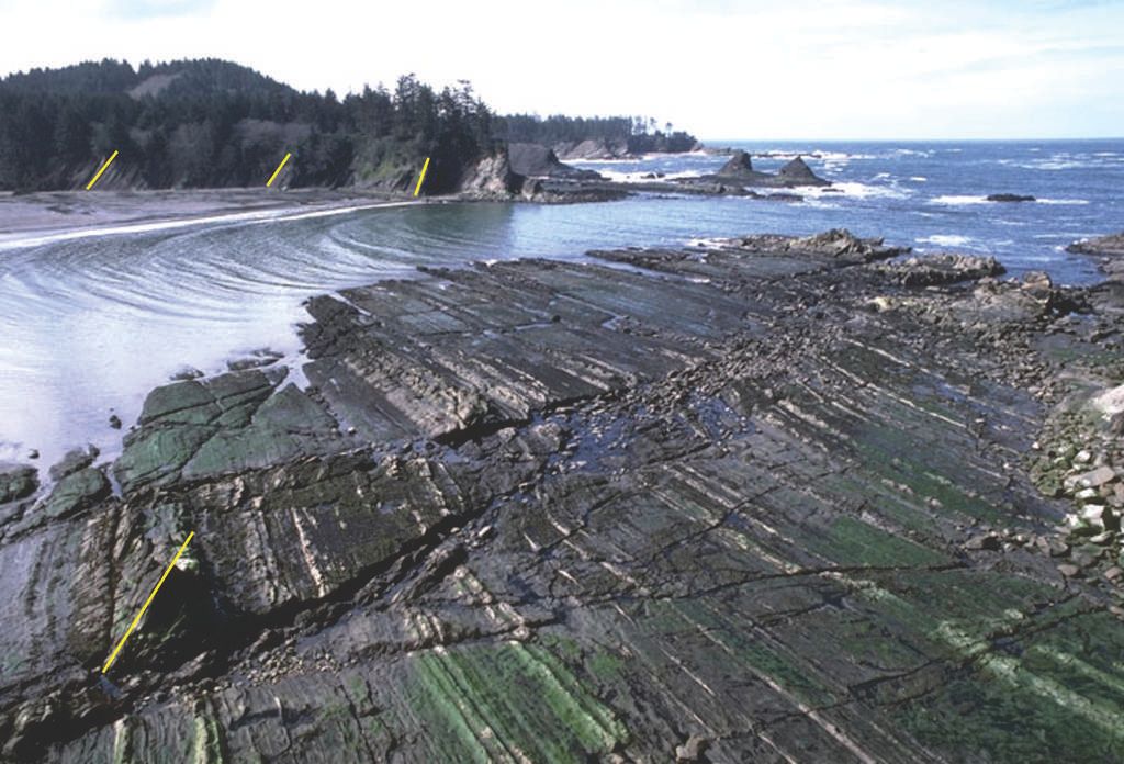
Yes, the basic idea is that, say, we have some on-land topography subjected to a rise in sea level. As sea level rises quickly enough, it will inundate that terrain and allow sedimentation to occur, burying the topography. As to the 'livable' places being destroyed, in most cases, I would expect wave action and shore erosion to completely eradicate any soil or soft sediment or even forests, etc. to be completely lost. Think about what wave action and storm surges do to a shoreline. Then think about that shoreline advancing across the continent with the rising sea level. So, the life living on that terrain (landscape) would only be preserved in basins (in which I include sand bars and swamps, etc.) that some how escaped erosion. That is the whole reason why terrestrial fossils are more rare than marine fossils. Once again, I show this picture from the Oregon Coast:
Note how the rocks in the foreground have been planed off by surf action. If sea level were lower, that would have been a 'landscape' with plants and animals on it just like the higher ground in the distance. Now, if sea level rose, the terrain (the terrace) would eventually go below wave base and start to accumulate sediments. If sea level subsided, then that surface would become a wave-cut terrace and form part of a nice flat landscape with a beach to seaward. In the background are some small to large high points that are slowly being eroded away. But if sea level rose quickly enough, they would form irregularities in the 'straight and flat' contact between the older rock and overlying sediments. And that contact would be an unconformity. I hope this helps.
|
||||||||||||||||||||||||||||||||||||||||||||
|
edge Member (Idle past 1736 days) Posts: 4696 From: Colorado, USA Joined: |
It might be worthwhile describing what happens with lake and pond succession, what processes take place and what the resulting layer composition would be.
Not quite sure what you mean, but a starting place would be to say that lakes are temporary, just like rivers and waterfalls. Generally, a lake is a water-filled basin in the topography of a land mass. It is a site of (local) deposition that receives sediments from the surrounding lands. It also receives the remains of organisms that live in the area, like this one from the Florissant Fossil Beds in Colorado:
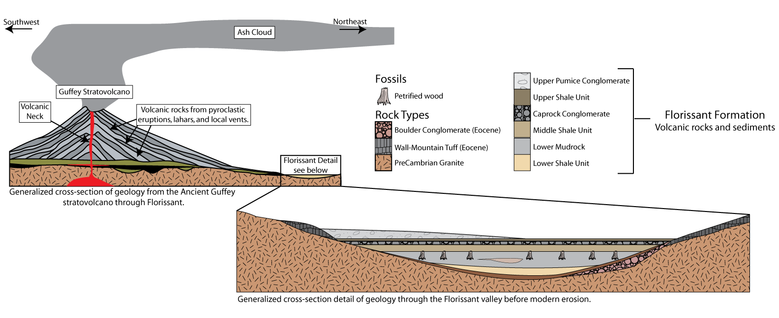
Eventually, a lake will fill in and essentially disappear. During its entire lifetime, a lake is subject to potential erosion unless it is protected or the effects of erosion never reach the basin. Here is a geological history for the fossil beds at Florissant"
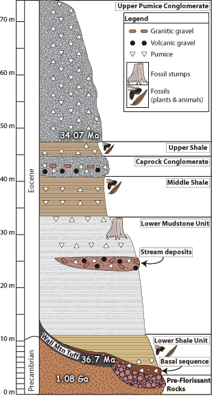
The beds are located in the depression that shows in the lower part of the diagram, near the Guffey Volcanic Center, but are now are being eroded by small streams which exposes the fossils for us to see. Here is a stratigraphic column (note that I do not use the term 'geological column') for the fossil beds.
Note the presence of a basin in the oldest rocks (Pikes Peak Granite), then filled in by various rock types including stream gravels, ash flows, and a thick succession of lake sediments including thinly bedded mudstone and shale. The section is capped (possibly assisting in the preservation of the lake sediments) by a thick pumice unit dated at 34.07ma. So, when the lake first formed, the granite all around was being eroded and it still is being eroded. But in the meantime, a very much younger, small lake has been preserved in the high country. Eventually, it too will be eroded away. But there's still time to go see it.  So, the pertinent points are that there was topography (a landscape) on very old rocks upon which a lake was formed at about 37ma ago. The strata lain down in this lake overlay older eroded rocks and now are being eroded themselves (as part of the new landscape). I'm not sure if this all makes sense. It is part of the discussion because it is a small basin in older rocks (granite) preserved beneath younger rocks (pumice) in a largely erosional environment (a landscape, terrain or topography, or what have you). Edited by Admin, : Make second image readable by providing a white background.
|
||||||||||||||||||||||||||||||||||||||||||||
|
edge Member (Idle past 1736 days) Posts: 4696 From: Colorado, USA Joined: |
Thank you for the modification of the diagram. What is easier to see now is how volcanic ash is falling from the sky and also coming into the lake in runoff. This kind of sediment is so fine grained that it can preserve the structure of fossils in fine detail.
Anyway, what we are seeing is how topography (landscape) in the granite was filled in by the lake, and then the lake was eventually covered (preserved) by pumice from the volcanoes. Notice how this all happens in what is basically an erosional environment: the land surface. There just happens to be a depositional basin and a source of fine-grained sediment.
|
||||||||||||||||||||||||||||||||||||||||||||
|
edge Member (Idle past 1736 days) Posts: 4696 From: Colorado, USA Joined: |
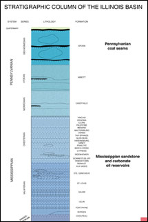
I've been looking for a stratigraphic column like this for some time now to present showing the actual state of affairs when it comes to the geological record.
This is a realistic column showing how rocks are added to the geological record during the Paleozoic in W Illinois.
As you can see, the record mostly consists of gaps. They are like sections of a tape (geological time) that either recorded nothing or were erased (by erosion). These gaps are indeed due to non-deposition and/or erosion of sediments and rocks that were deposited during the gaps; and are typical of continental sedimentation. Basically, there are four separate packages of rocks all separated by unconformities. The column even shows schematically how the base of each package fills in pre-existing topography. Compare that to a more typical section, such as the ones that Faith is accustomed to dealing with:
In this case, unconformities are usually shown with a wavy line between sedimentary units, or as in this case, not even that. The point is that erosion is an important part of the geological record, particularly in continental areas, and what we see in the literature often ignores this fact. Erosion leaves behind a topography (landscape) that is later buried and preserved. Hope this helps, but it is kind of hard to wrap ones mind around it if you can't think in the time dimension.
|
||||||||||||||||||||||||||||||||||||||||||||
|
edge Member (Idle past 1736 days) Posts: 4696 From: Colorado, USA Joined: |
Is there a higher quality version of this chart? The text is very difficult to read.
I don't know of a higher quality image. Most stratigraphic columns are not presented this way, so I took the only one I could find. Here are my interpretations, please correct as necessary. Is it correct that the left side of the chart is just the geological periods, provided as a reference? On the left is a geological time scale, but there is a separate column for major transgressional episodes. And yes, they actually have names like Tippecanoe and Kaskaskia. Each of these transgressions is represented in the graphic column on the right, showing the rocks deposited during each transgression. There are 4 major transgressions in the Phanerozoic all represented by 4 sets of blobs on the diagram.
And to the right of the geological periods are the stratigraphic details from different locations in western Illinois, namely around Colchester, around Warsaw/St. Louis (which are 140 miles apart), and around St. Clair/Moccasin Springs? (The layers at the very top of the diagram mention no location.)
Those names are actually the names of geological formations, except for the Colchester No. 2 which is a coal seam.
At each of these locations mentioned the geographic periods that have no layers are simply not represented at that location. Either layers deposited during those periods were later eroded away, or no layers were deposited for those periods, or some combination of deposition then erosion then deposition then erosion, etc., leaving behind what we see today.
This is exactly correct. The gaps are time periods where there is no geological record. This is the point that I was hoping to show. Time is moving from bottom to top and parts of the time there were rocks being deposited in this part of Illinois, or else there were rocks and they were eroded. There is another dimension in this diagram that is helpful. The graphic part is to the west on the left and to the east on the right. The little notches on top of the blobs and the tabs on the bottoms of the blogs show how channels were cut into the tops and then filled later during the next transgression. The second illustration was more of a traditional stratigraphic column which I will replace with this more familiar one:
You can see how the formations are in direct contact to each other, for the most part with a straight (and flat) line. While this is accurate, there is so much more information in the Illinois column that we are looking at. However, traditionally, the contacts between formations in this type of column are shown as wavy when there is an unconformity.
|
||||||||||||||||||||||||||||||||||||||||||||
|
edge Member (Idle past 1736 days) Posts: 4696 From: Colorado, USA Joined: |
And in the following picture we are seeing sections from one location not from several different locations.
Actually, it's almost like a cross-section. Notice the 'West' and 'East' labels at the bottom of the diagram.
The gaps simply represent material that is missing and the intersections of those areas where there is material in reality fit together but with unconformities.
Yes in 3D space all of the units would be stacked. This diagram includes time as a dimension.
Is that correct? Are we seeing that the layers in that column really are not flat and smooth and do show internal signs of erosion and deposition?
The could locally be flat, but as the thicknesses of the formations and little channel slots show, these are continental sediments. They do not persist across the continent.
Also do you have anything that shows the original size and heights of the Guffey Strato-Volcanoes related to their heights today? That may help explain part of the process. I doubt that a study has been done. However, for various reasons, we could say that it was between 500 and 2000m above the base of the volcano. Edited by Admin, : Add quote of text that the last response was replying to.
|
||||||||||||||||||||||||||||||||||||||||||||
|
edge Member (Idle past 1736 days) Posts: 4696 From: Colorado, USA Joined: |
This was my original interpretation, but then I became uncertain and wondered if the top of each of the four stratigraphic columns represents a modern topography at four different locations in western Illinois.
They represent the topography from west to east after erosion to those levels. They represent terrain, aka 'landscape' which is then buried by the next transgression.
They all slope downward toward the west, so perhaps that's because they're bounded on the west by the Mississippi River?
The Illinois Basin occurs to the east, so that is where the sediments are thicker, especially for the Tippecanoe sequence. Erosion occurred earlier at the edges of the basin.
|
||||||||||||||||||||||||||||||||||||||||||||
|
edge Member (Idle past 1736 days) Posts: 4696 From: Colorado, USA Joined:
|
The boundaries between adjacent stratigraphic layers that are not unconformity boundaries appear to be very flat and straight in the diagram, but I'm guessing that Jar was actually asking about the uncomformable boundaries between the stratigraphic groups.
Exactly.
For example, the bottom of the next to last stratigraphic section includes the Wapsipinicon and Hsing ss formations (apologies for misspellings, the text is fuzzy), and they appear to be above a sloping and irregular unconformity.
No problem. The tops of the blobs are erosional and the bottoms show the beginning of deposition of a new sequence. I guess I can see that this is kind of a complex diagram for a forum such as this. There is no such thing as a physical slope in this diagram because the vertical dimension is time. Any horizontal line represents a point in time, not a contact per se, even thought the rocks are in normal stratigraphic contact. The lower contact shows when sedimentation began at any particular point. So for the Kaskaskia sequence, sediment was deposited earlier in the west than in the east. But for the most part it all began at one time in the other sequences. The point here is that there is more erosion on the west side. My purpose in presenting this diagram was to show how the continental rock formations do not express continuous sedimentation because of lengthy periods of lost record due to the emergence of a landscape and its erosion. The four sets of 'blobs' are periods of marine transgression across the continent with periods of subaerial erosion in between. If you remember my recording tape analogy, the tape is running from bottom to top of the diagram and the gaps are missing information. They have been erased and/or not recorded in the geological record. These periods (Tippecanoe, etc.) are continental-scale transgressions recognized in North America. There are actually six of them but two are not preserved in the area shown. Just think of the sea moving in and then moving out, leaving behind a record of sedimentation each time over millions of years. As I mentioned, I guess this is way too technical. My intent was to show the presence of erosion in the geological record and the inundation of pre-existing landscape in a way that showed the strata and how they formed. My apologies for the confusion Edited by edge, : No reason given.
|
||||||||||||||||||||||||||||||||||||||||||||
|
edge Member (Idle past 1736 days) Posts: 4696 From: Colorado, USA Joined:
|
Layers of evaporites are often relatively flat since they form at the surface of water from solar evaporation. Precipitates also form fairly flat layers since they to are formed from a uniform solution. Annual layers of fine particles also form fairly flat layers in lakes and oceans since they're moderated by gravity and the fluidity of water. We also would expect to get fairly flat layers from windblown deposits and see particle size sorted flat layers as rivers and streams deposit the dirt, debris and silt they carry at the river delta.
I imagine this is possible, but I can't locate any definitive work. Just off the top of my head ... It seems to be that there is one other factor that should produce relatively flat layers and that is when the layer is deeply buried. When something is buried deeply pressure is applied equally from all sides. If I remember correctly pressure increases at a figure of over 7000 pounds per square inch for every mile of depth so at only two miles we would see over 14000 pounds per square inch pressure. If you have a formation that is homogeneous, compressible; and has some strength and some irregularities on its surface like mud cracks or burrows or fossils, and if it is loaded evenly, then flattening and apparent smoothing of the contact should occur as those irregularities are compressed. The problem is that, often, rocks and sediments don't cooperate in detail. I think there are better reasons for 'straight and flat' contacts of the type that Faith talks about, such as irregular thicknesses showing that they don't really exist. I think that even loading of sediments by a 'rain' of fine grained material that would happen in most offshore marine environments would give you just what she claims is impossible. Even turbidites would form flat deposits as they spread our over large areas of the seafloor. We have certainly provided plenty of images of such contacts that are not as straight and flat as they would appear at a larger scale; but for some reason, she has the idea that those are not 'strata' (her definition). But we have an adamant YEC, and nothing will ever suffice to explain.
|
||||||||||||||||||||||||||||||||||||||||||||
|
edge Member (Idle past 1736 days) Posts: 4696 From: Colorado, USA Joined:
|
From my point of view this thread was over some time ago, and what is going on now is simply irrelevant. Nobody is addressing the problem the thread is about.
Your opinion is noted.
Stack of flat rocks, each representing a former depositional environment or landscape where the rock is now, can't have happened although the processes involved are very hard to spell out, Try imagining the depositional and erosional processes that would have to occur for each transformation from landscape to rock keeping in mind a particular stack of rocks as they exist today.
No problem. Constructing geological histories is part of what geologists do. If you could be more specific about what your issue is, perhaps we could address it. As far as I can see, you simply deny any reasoning or evidence that we provide.
If you're really doing this, you will run into insurmountable problems.
I have seen problems, but none insurmountable.
To keep the creatures alive You start multiplying landscapes that aren't part of the final stack of strata; or you move them out of the area where their fossils happen to have been found; you get sediments piling up that have nothing to do with the final stack of strata, being there only because they are needed to bury one sediment so it will lithify.
This doesn't make any sense to me. Could you perhaps list the sequence of events, one by one? Maybe you could start with the Great Unconformity and follow the rock sequence up through time.
But some of these extraneous sediments would themselves lithify in the time allotted to lithify those that are in the stack of strata.
Why could this not happen?
You try using the sediments that do occur in the strata but the former landscape hasn't been covered or eroded enough for another to form on top of it; You keep destroying the habitats of the creatures that supposedly lived there, as evidenced by their fossils being found there.
AFAICS, we are not destroying those environments, but preserving them. They probably don't look the same, but there you are trees and leaves and bugs, the whole nine yards.
I don't know what you all think you are doing but you aren't focused on the problem posed by this thread.
The problem is probably not with mainstream geology, but with your understanding of natural processes along with your dogmatic acceptance of a young earth.
|
||||||||||||||||||||||||||||||||||||||||||||
|
|
Do Nothing Button
Copyright 2001-2023 by EvC Forum, All Rights Reserved
![]() ™ Version 4.2
™ Version 4.2
Innovative software from Qwixotic © 2024


 (1)
(1)