|

Understanding through Discussion |
|
|
Register | Sign In |
|
QuickSearch
| Thread ▼ Details |
|
Thread Info
|
|
|
| Author | Topic: Earth science curriculum tailored to fit wavering fundamentalists | |||||||||||||||||||||||||||
Faith  Suspended Member (Idle past 1474 days)  Posts: 35298 From: Nevada, USA Joined: |
I just explained it. Water running across the layers before deposition of the next or between layers after. No problem whatever.
|
|||||||||||||||||||||||||||
|
Faith Suspended Member (Idle past 1474 days) Posts: 35298 From: Nevada, USA Joined: |
Oh yeah, all that minuscule "sub-aerial" erosion. Compare it to the massive erosion that we can see occurred after all the strata were laid down, the cutting of canyons, the scouring of huge flat surfaces of particular layers, such as the Kaibab plateau, the cutting of steppes, the tilting and folding of whole depths of layers, and so on. Claims of internal erosion are ridiculous by comparison. Where are the huge canyons in the internal layers, filled in by the upper layers, and so on. You are simply not seeing the actual evidence.
ABE: No, the erosion after the stack was built wasn't necessarily sub-aerial, a lot of it was probably created in the receding phase of the FLood. Edited by Faith, : No reason given.
|
|||||||||||||||||||||||||||
|
Faith Suspended Member (Idle past 1474 days) Posts: 35298 From: Nevada, USA Joined: |
Sure it can. Some layers would have been deposited as the waters receded, sub aerially.
However what you call subaerial erosion isn't, it's a delusion. This is all a rabbit trail though, making mountains iout of molehills because the original observation I made is a killer for geo time. Edited by Faith, : No reason given.
|
|||||||||||||||||||||||||||
|
Faith Suspended Member (Idle past 1474 days) Posts: 35298 From: Nevada, USA Joined: |
Demonstrated:
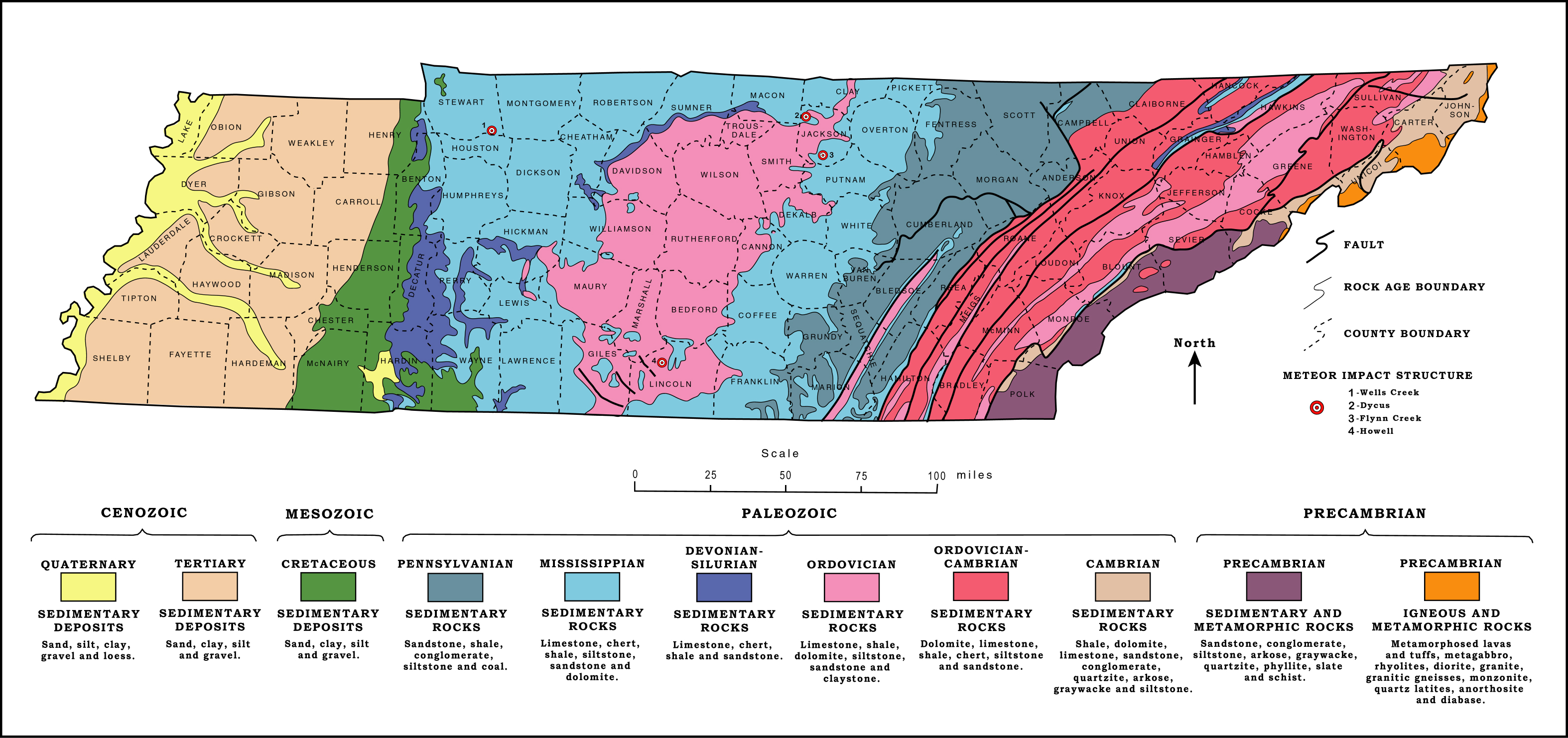
See map
Note colored areas that designate "time periods." Physically they are steppes or terraces that ascend from right/East to left/West, with the exception of the pink Ordovician which is a low butte in the middle of the blue. Those are all surfaces of layers that were exposed by the erosion of the layer above. The surfaces are quite extensive. Of course they are no longer flat and horizontal since the whole area has been tectonically warped, but the principle is there nevertheless. This is erosion that obviously occurred after the entire stack was in place. This extensive erosion can be seen everywhere the geologic column exists. There is nothing even remotely like the extent of this erosion within the strata. This is clear evidence against hundreds of millions of years. ABE: The tectonic movement of course also occurred only after all the strata were in place, which is also evident wherever the geo column exists, with the supposed exception of the "great unconformity" that can be seen between the basement/Precambrian rocks and the strata above. This tectonic movement is no doubt the cause of the massive erosion that occurred after all layers were in place, and I've argued also the cause of the "great unconformity" but we don't have to argue that here. I've clearly argued that this massive erosion occurred in the Grand Canyon area after all strata had been laid down, and that claims of so-called erosion within the stack are ridiculously out of scale, so those who think this is something new haven't been paying attention. Edited by Faith, : No reason given.
|
|||||||||||||||||||||||||||
|
Faith Suspended Member (Idle past 1474 days) Posts: 35298 From: Nevada, USA Joined: |
You and I have a sad record of miscommunication and I can only expect more of the same here, but oh well.
Faith writes: Note colored areas that designate "time periods." Physically they are steppes or terraces that ascend from right/East to left/West, with the exception of the pink Ordovician which is a low butte in the middle of the blue.
edge writes: Actually, it is an arch. Because the sediments are bowed upward, erosion has removed some of the post-Ordovician rocks. Think of it as a broad anticline or a dome OK, but that's the result of tectonic distortion which occurred after all layers were in place, right? I was referring to the order of deposition which originally would have been horizontal and continuous across the whole area. Now the layers have been broken off or partially eroded away and if they were still horizontal they'd ascend up from one layer to the next from the oldest, Precambrian rocks on the East. to the most recent, Quaternary rocks on the West. But I'm aware they've been twisted tectonically so aren't the neat steps they suggest on the map. Tennessee is interesting, however, because it spans just about the whole Geologic Time Scale. What I'm focused on is the surface area of the stata without the tectonic deformation which is the eroded remnants of all the layers in the Geologic Time Scale in the form of steps or terraces, the oldest exposed on the East, the newest on the West. The principle in my mind is the principle of original horizontality, but also the principle of original superposition. From here we go into Extreme Miscommunication Mode, I'm almost afraid to proceed at all.
This is erosion that obviously occurred after the entire stack was in place.
This sentence does not track with what you are saying below. It tracks with everything I've said but as usual you are reading something I wrote completely out of synch with what I said and I can never figure out what you mean so here we go into Headache Land. The erosion I'm talking about is on the surface of the land, extends from east to west, removed sediment from each of the layers starting at the east so that the eroded parts form steps or terraces that climb upward to the west. ASSUMING ORIGINAL HORIZONTALITY that is: I KNOW THEY ARE WARPED NOW so that they don't form flat terraces. Here is one cross section of Tennessee to show how the strata are bent now:
The strata are bent and twisted in all sorts of directions but they are only ERODED or broken off at the surface.
This extensive erosion can be seen everywhere the geologic column exists. There is nothing even remotely like the extent of this erosion within the strata.
You just said they were exposed by erosion and they are quite extensive. As usual I have no idea how you are misreading me but ulcer time is coming up, probably for both of us. The erosion occurred after they were all in place, exposing the formerly buried surfaces of each of the layers in turn from east to west, so that extensive areas of each are exposed on the east end of each, where they broke off and exposed the layer beneath one after another. I do not know how to make this any clearer. THE EROSION OCCURRED AFTER THEY WERE ALL IN PLACE, not during deposition, AFTER. The entire surface area of Tennessee appears to be made up of these partially exposed layers that form terraces, or would if they were still horizontal. I wish I could draw on Paint better but it doesn't work.
This is clear evidence against hundreds of millions of years.
I don't see why. Why can't you have a lot of events over millions of years? Because it all happened on the surface, that is, since the last layer was laid down, that being the Quaternary layer, which is only two and a half million years old according to official Geological Time. (Of course I believe it all happened about 4500 years ago but oh well, two and a half million years is short on your reckoning.) Point is the layers beneath that one formed over much much older and longer time periods. If any of this erosion had occurred before Recent Time it would not have formed steps. Some of the layers would likely have been eroded much more extensively in the westward direction during the much much longer periods during which they supposedly formed, and in that case layers above would have deposited into the gaps created by the erosion. But no, they make up the continuous step-wise upper surface of the state of Tennessee. I'm sure you'll just give your usual dismissal because you just don't get it but it's really very obvious. There is no erosion within the strata, it's all on the surface, therefore having occurred after all the layers were in place, or in Geological Time since the Quaternary which is represented on the far left of the map of Tennessee:
If any of this erosion had happened over the hundreds of millions of years of deposition there would not be a continuous stack of strata, there would be all kinds of depressions the strata would have filled up. Instead there is only the erosion of the eastern ends of the layers, all forming the surface of the land.
ABE: The tectonic movement of course also occurred only after all the strata were in place, which is also evident wherever the geo column exists, with the supposed exception of the "great unconformity" that can be seen between the basement/Precambrian rocks and the strata above.
This isn't what you said above. Please explain. Oy. I don't know which part you are objecting to, but as far as the role of tectonic movement goes, the deforming of the strata itself, seen on the cross section, would have loosened and eroded away parts of the layers after they were all in place. Just as I argued happened in the Grand Canyon/ Grand Staircase area as well, in that case creating the staircase itself and the Grand Canyon itself as well as Zion Canyon, as well as scouring off the Kaibab plateau. In Tennessee it warped the geologic column and caused pieces of the strata to break off and erode away. (Which on my usual scenario would mean these pieces were washed away in the receding Flood waters, same as in the GS/GC area.)
This tectonic movement is no doubt the cause of the massive erosion that occurred after all layers were in place, and I've argued also the cause of the "great unconformity" but we don't have to argue that here.
How is tectonism the cause of erosion? As stated above, twists the strata, shakes things up, pieces break off and erode away. You know, the way the earthquake in Nepal eroded off chunks of the Himalayas.
Do you think there could be more than one tectonic event? Could be but I don't see any reason for more than one major such event in the exposing of the layers here.
I've clearly argued that this massive erosion occurred in the Grand Canyon area after all strata had been laid down, and that claims of so-called erosion within the stack are ridiculously out of scale, ...
Again, you just said that the erosion between layers is extensive and caused by warping. This is a confusing post. Sigh. All my posts are confusing to you. While I could no doubt be clearer if I could figure out what the problem is, really for the most part it's predominantly a paradigm clash. You have no good will to assist in resolving it and we really shouldn't even talk to each other. I don't know what you are misreading now but I've said nothing about erosion BETWEEN layers because there is none, there is erosion of the surfaces of the layers on their east ends which all break off and expose a lower layer in each case, all of which together form the whole land surface of the State of Tennessee. As for warping that's the effect of the tectonic movement that also occurred after the layers were all in place and as I say above is probably what brought about the erosion by bending and twisting the strata.
There is a major unconformity in the section shown at the base of the Cretaceous. This indicates an erosional event after the Palezoic rocks were laid down, deformed and eroded, but before the Cretaceous rocks. Sigh. You are comparing a small local event to the entire eroded surface of the State of Tennessee, and since you don't bother to describe it I can't answer it directly, which is a typical strategy of yours. Edited by Faith, : No reason given. Edited by Faith, : No reason given.
|
|||||||||||||||||||||||||||
|
Faith Suspended Member (Idle past 1474 days) Posts: 35298 From: Nevada, USA Joined: |
Faith, you are leaping into a complex subject without any preparation. There are no relevant complexities in the part I've focused on. What I've said is based on simple observation and is true as stated.
First of all, the geological map and your cross-section are not indexed to each other. I KNOW THAT FOR CRYING OUT LOUD. THAT'S IRRELEVANT TO THE POINT I'M MAKING. Why can't you ever deal with what has been presented? I'm not interested in analyzing all the geological particulars of the State of Tennessee, I made some simple observations that are in accord with others I've made elsewhere and they hold up for the point I'm making. The cross section was intended only to emphasize the fact that the strata are not eroded internally, that the erosion occurs only on the exposed surface of the land. There is no reason to think other cross sections would show anything different in that regard but if you have one then produce it and stop making up problems that don't exist.
The cross section is on a completely different scale encompassing only the Carolina Thrust Belt on the very eastern edge of Tennessee. IRRELEVANT TO THE POINT I'M MAKING.
The map shows that as you go farther west into Tennessee, you get less and less disturbance from the Appalachian mountain building event. For instance, the large dome I referenced in my last post does not even show up on the cross section you present. ABSOLUTELY IRRELEVANT TO THE POINT I'M MAKING.
And, no, there is not just one erosional event. For instance, the Cambrian rocks depicted on the geological map include arkoses which are derived from erosion of granitic basement rocks of the Precambrian. Furthermore there is a gap in the record between the Pennsylvanian rocks and the Cretaceous rocks in western Tennessee. And then, of course, there are other minor unconformities within the section that do not show up on a map of this scale. I will try to find a strat section that shows more, but most of the diagrams I find are insanely detailed and not appropriate for a discussion like this. You are too detailed as it is. All of this is TOTALLY IRRELEVANT TO THE SIMPLE POINT I'M MAKING.
As usual, the picture is a lot more complex than YECs would like. I have no idea what "YECs would like" but the complexities ARE IRRELEVANT TO THE POINT I'M MAKING.
Perhaps more later. I have a little work to do. Oh PLEASE don't trouble yourself. I've made my point well enough and no further input is needed.
|
|||||||||||||||||||||||||||
|
Faith Suspended Member (Idle past 1474 days) Posts: 35298 From: Nevada, USA Joined: |
No you don't have to exclude the rest of the state, the cross section was meant as an illustration of what I'm arguing, not to be a big part of the argument itself. As I said, if there are cross sections from other parts of the state that show something else bring them on, but my guess is this one suffices to illustrate the general situation.
The rest of your post doesn't make sense to me except that it shows your complete lack of comprehension of the point I'm trying to make. If I figure out what you are saying maybe I'll come back and answer it, otherwise I'm perfectly happy to leave things as they are. My scenario works beautifully, really wish you could see it, but you're got all those irrelevant details blinding you. Edited by Faith, : No reason given.
|
|||||||||||||||||||||||||||
|
Faith Suspended Member (Idle past 1474 days) Posts: 35298 From: Nevada, USA Joined: |
So as usual I'm up against a massive interpretive fiction. Sigh.
|
|||||||||||||||||||||||||||
|
Faith Suspended Member (Idle past 1474 days) Posts: 35298 From: Nevada, USA Joined: |
Yeah, so you all believe, without knowing it IS just a belief, a prejudice. Sigh.
|
|||||||||||||||||||||||||||
|
Faith Suspended Member (Idle past 1474 days) Posts: 35298 From: Nevada, USA Joined: |
Interpretations of the timing of events in the supposed ancient past are all imposed by theory, all assuming the ridiculous Geologic Time Scale. The actual physical work of Geology is something else entirely, but those who have bought into the Time Scale have no ability to tell the difference.
|
|||||||||||||||||||||||||||
|
Faith Suspended Member (Idle past 1474 days) Posts: 35298 From: Nevada, USA Joined: |
I'm sure the origin of arkose is part of the actual work of Geology and not the Geologic Time Scale assumption. There is no evidence for the Geo Time Scale, it's all assumption based on theory, so it makes no sense to expect a YEC to challenge it on evidentiary grounds. We challenge it all the time on logical grounds but that you'll never accept. For instance it IS clear that the Time Scale has come to an end and I've given all sorts of good reasons why that is the case, that is even really evidence, that you'll never even understand let alone accept.
Edited by Faith, : No reason given.
|
|||||||||||||||||||||||||||
|
Faith Suspended Member (Idle past 1474 days) Posts: 35298 From: Nevada, USA Joined: |
I am far from expert on the geology of the state, but everything about it negates the premise that Faith has adopted. The fact is that the thrust belt shown in the cross section occurred in the mid-Paleozoic and did not affect the Pennsylvanian and later rocks. Since this discussion has been given the go-ahead to continue for now, I'll ask you to state how you arrive at the conclusion the thrust belt "occurred in the mid-Paleozoic."
Not only that, but the Cretaceous rocks shown on the map are more related to development of the Mississippi Embayment in Mesozoic time. Same question concerning this statement.
That's at least two major tectonic events prior to the time that Faith thinks all deformation occurred (that would be after all sedimentary rocks were deposited). And I'm not even getting into the Precambrian geology. Since the time periods are all fiction to me I expect your explanation of the timing of the above events to likewise be based on the assumption or fiction. Thank you.
|
|||||||||||||||||||||||||||
|
Faith Suspended Member (Idle past 1474 days) Posts: 35298 From: Nevada, USA Joined: |
However, I still don't see the disconcert over a section of geology in which there happens to be little erosion. So what if sedimentation is continuous for most of the Paleozoic Era? There was pretty obviously some erosion before the Cambrian and certainly some prior to the Cretaceous Period. All that is in addition to the modern erosional surface on which we live. Your scenario of one erosional surface in the history of the earth simply does not work. What is the "obvious" evidence of the "erosion" you are referring to "before the Cambrian" and "prior to the Cretaceous" that you say is "in addition to the modern erosional surface on which we live?" This last phrase, however, inspires me to use it to generalize my argument. The "modern erosional surface on which we live" is indeed what I keep coming back to as the evidence for all kinds of things I've been saying. This erosional surface is MASSIVE and UNLIKE anything you all call erosion to be found within the Geologic Column. In the Grand Canyon arguments I keep trying to get someone to notice that the scale of the "modern erosional surface on which we live" includes the massive canyon itself, includes the massively scoured-off surface of the Kaibab Plateau, includes the massive cliffs that make up the Grand Staircase, and yet everybody keeps claiming there is "erosion" between the layers of the walls of the Grand Canyon itself. NONSENSE. Whatever is going on geologically with that thrust under the State of Tennessee it still remains true that the surface of the state, that is, the"modern erosional surface on which we live" is clearly indicated on the map to involve a series of terraces formed from the eroded remnants of the layers of the Geologic Column. The idea that this Geologic Column, and therefore the Geologic Time Scale, continues into the present, beyond the so-called Quaternary, or the Holocene or whatever the most recent time period is supposed to be, when all the previous "time periods" are represented by mere SLABS OF ROCK, is LUDICROUS. The "erosional surface on which we live now" is composed of MASSIVE MOUNTAINS, DEEP VALLEYS, RIVER GORGES, BUTTES, MASSIVE TEPUI, ENORMOUS RIVERS LIKE THE AMAZON AND THE MISSIPPI, and yet the claim is that whole eras of past time in chunks of hundreds of millions of years on this planet are collapsed into slabs of rock. Wny isn't the blatant absurdity of this OBVIOUS? Edited by Faith, : No reason given.
|
|||||||||||||||||||||||||||
|
Faith Suspended Member (Idle past 1474 days) Posts: 35298 From: Nevada, USA Joined: |
Evidence of water running deep underground in patterns typical of water, nothing hard to explain about that. And it's limited to areas here and there, also contained in a slab of rock so what could it possibly prove? The idea that a topographically varied surface like today's would end up buried under slabs of rock is absurd. Why isn't this obvious:? How do smart scientists go on accepting such nonsense?
Edited by Faith, : No reason given.
|
|||||||||||||||||||||||||||
|
Faith Suspended Member (Idle past 1474 days) Posts: 35298 From: Nevada, USA Joined: |
The idea that a topographically varied surface like today's would end up buried under slabs of rock is absurd.
Quite so. What we actually expect is that the low-lying features would be buried under sediment and/or sedimentary rock, and the prominent features would be eroded. Which is what we actually see evidence for.
You alone are responsible for the absurdity of your ideas. Actually you don't SEE evidence for that at all. Here and there you find something that sort of reminds you of such a thing and it fits with the theory so you baptize it Truth although the vast preponderance of evidence doesn't fit at all, but then you go find something else that sort of fits with the theory until you have all this "evidence" (ha ha) to keep convincing you the whole thing makes sense. Meanwhile we're talking a deep (miles deep) stack of different kinds of sediments that spans entire continents. How DO you maintain your fantasy of different time periods nicely tucked away in those slabs of different kinds of rock? Really, the amazing thing here is how intelligent people can believe such stuff. Right, all this varied topography with its extreme highs and lows and different kinds of rock composition can simply be EXPECTED to scrunch into a slab of rock of one particular kind of sediment or perhaps a few layered together, with quite level surfaces top and bottom in most cases too, spanning an entire continent for the ages to come, just as did all the other dozens of earth scenarios over hundreds of millions of years, they just neatly fill up the low spots and erode down the high spots like they were packing a bag for the trip. All into one particular kind of sediment, how amazing is that? Or like those books for little children with their cutout scenes that fold up when you turn the page. Science says so, it's predictable, it's happened over hundreds of millions of years and it will therefore happen again and you all think this makes sense. Welll, you have enough common sense to know it isn't going to continue on top of the existing Geologic Column though, don't you. No, it's now continuing at the bottom of the ocean where we can be sure it will collect all the fossils of this current time period so as not to badly confuse future geologists. You all think the walls of the Grand Canyon with their differently colored straight flat slabs of rock represent former similarly topographically lumpy earth surfaces, or ocean scenes, whichever the slab represents. You think the dead things contained in many of them are what populated that landscape, those and only those contained therein. The absurdities go on multiplying as the facts are tallied. And then we have to believe that those rocks only began to get unpacked in OUR time, massively eroded as the Grand Canyon area, or the State of Tennessee for that matter. But they'll pack up neatly when the time comes, when the Evolution genie says Go. The emperor really doesn't look very attractive naked. The scientific imagination is a marvel. Edited by Faith, : No reason given.
|
|||||||||||||||||||||||||||
|
|
Do Nothing Button
Copyright 2001-2023 by EvC Forum, All Rights Reserved
![]() ™ Version 4.2
™ Version 4.2
Innovative software from Qwixotic © 2024