|

Understanding through Discussion |
|
|
Register | Sign In |
|
QuickSearch
| Thread ▼ Details |
|
Suspended Member (Idle past 1474 days)  Posts: 35298 From: Nevada, USA Joined: |
|
Thread Info
|
|
|
| Author | Topic: The Geological Timescale is Fiction whose only reality is stacks of rock | |||||||||||||||||||||||||||||||||||||||||||||
|
edge Member (Idle past 1736 days)  Posts: 4696 From: Colorado, USA Joined:
|
What we actually see from experimental testing with flumes, is that uniform principles do not apply to flowing currents which provably show that facies can be created quickly, and they break both the principle of superposition and continuity.
Not really. Just because a stratum (or lamination) is inclined does not mean that it is older than the inclined stratum beneath it. I'd rather like to know how you deposit a grain of sand, for instance, with out previously deposited grains to support it. By the way, you are breaking Faith's rule that there are is no such thing as inclined deposition by invoking cross-bedding. And yes, some beds of sediment are created quickly ... millions of years ago. We have known this since the early days of geology. ETA:
The Coconino sandstone in the Grand Canyon has many track-ways (animals), but is almost devoid of plants. Implication: these rocks are not ecosystems but are evidence of catastrophic transportation.
So, how do you preserve delicate tracks in water-saturated, current-deposited, water-saturated conditions? And where are the dinosaur ecosystems during the Cambrian? And how do their tracks get transported to the Mesozoic and coincidentally end up in the same aged rocks as the skeletal fossils? And nests with eggs? You appear to have a truly magical fludde. Edited by edge, : No reason given.
|
|||||||||||||||||||||||||||||||||||||||||||||
|
edge Member (Idle past 1736 days) Posts: 4696 From: Colorado, USA Joined:
|
Your post makes sense to a degree, but not when we consider the actual fossils that exist, a lot of them in the middle of fighting, giving birth,
So, animals don't die giving birth, or choking on a large meal?
... or their necks thrown back in the suffocation position.
Heh, heh, I don't suppose you'd consider that neck muscles will contract upon death and dessication of the carcass ...
When we consider the fossilization of soft-tissued fossils such as jellyfish or whatever..
And what?
... and what about the diving-Ichthyosaur that had it's head buried in one million years worth of rock.
Please document.
While your explanation is plausible, it isn't based on real science, only assumptions of uniformity.
Well, then prove uniformity in its modern sense to be wrong.
|
|||||||||||||||||||||||||||||||||||||||||||||
|
edge Member (Idle past 1736 days) Posts: 4696 From: Colorado, USA Joined: |
It's pure bullshit. Quelle surprise. http://plesiosaur.com/creationism/analysis.php?artiID=20 Just today I was explaining the thick, soupy mud that occurs at the bottom of standing bodies of some bodies of water. It was easy for an 7-year old to understand.
|
|||||||||||||||||||||||||||||||||||||||||||||
|
edge Member (Idle past 1736 days) Posts: 4696 From: Colorado, USA Joined: |
The supposed seismic imagery of deeply buried "landscapes" has come up here many times and my answer is those are not actual landscapes that were ever on the surface of the earth, but simply features like "canyons" carved by running water, probably after being deposited and buried, that got filled in by the next layer of sediment. That's really the only kind of thing that is seen on that sort of imaging, not enough to hang an entire landscape on of the sort we see on the surface of the earth today.
So, canyons are not real landscapes? So if this canyon was filled in and covered by the next layer of sediment, it was never a canyon?
So, maybe it's just a "canyon" and not a canyon, is that correct? Maybe you could tell us what a "canyon" is.
|
|||||||||||||||||||||||||||||||||||||||||||||
|
edge Member (Idle past 1736 days) Posts: 4696 From: Colorado, USA Joined:
|
So, canyons are not real landscapes?
Not what I said.
So if this canyon was filled in and covered by the next layer of sediment, it was never a canyon?
No.
So, maybe it's just a "canyon" and not a canyon, is that correct?
No.
Maybe you could tell us what a "canyon" is. No. I'm having a hard time seeing any alternative interpretation to the buried landscape interpretation of the data. What do you see or not see that convinces you of your position? For instance, here is some data from the San Joaquin Valley:
How is this not indicative of previous topography?
|
|||||||||||||||||||||||||||||||||||||||||||||
|
edge Member (Idle past 1736 days) Posts: 4696 From: Colorado, USA Joined:
|
What's so odd about the idea that the Flood should have left shorelines?
Well, the main problem is that a shoreline implies a land surface because shorelines are the interface between land and water. You will notice in your images that above the highest shoreline, there is land without shorelines. The point is that we can recognize shorelines in the geological record. For instance, the Dakota Sandstone records a shoreline that advanced across the mid-continent of North America. The problem is that it did not cover all of the land. There were emergent areas to both the east and to the west; hence there was topography above sea-level ... a landscape.
|
|||||||||||||||||||||||||||||||||||||||||||||
|
edge Member (Idle past 1736 days) Posts: 4696 From: Colorado, USA Joined:
|
No landscapes BETWEEN STRATA is the idea, or even "within" strata since that's implied too. The only landscapes on the surface would have been before the Flood, ... ; and the landscapes that have formed after the Flood. Looking at the strata all that you see is tight lines between them, but wherever there is an exposed surface you get hills and valleys, trees and other living things -- which is how I'm using the term "landscape."
Of course they leave clues. That's why we say that there were ancient landscapes. What we are arguing is whether there was ever a surface landscape in, say, the "Devonian period," or the "Permian," or the "Jurassic" etc, which would supposedly have left SOME clues instead of those flat straight contacts between their strata and the next. We have offered to you things like river channels cut in various older formations, drainage patterns in the lower Paleozoic, and paleosoils at a number of locations. I have also asked repeatedly how we get trace fossils such as footprints injected into the geological record during a massive flood. Your implication is that fossils were transported there, somehow, but what about footprints? Of course, I'm making the wild assumption that dinosaurs actually walked on landscapes. Is that crazy, or what?
|
|||||||||||||||||||||||||||||||||||||||||||||
|
edge Member (Idle past 1736 days) Posts: 4696 From: Colorado, USA Joined:
|
Mostly what I see is the strata, strata, strata and more strata, those originally flat straight sedimentary deposits that are now great slabs of rock piled very deep and often extending for huge distances.
The problem is that those are marine deposits. It is their nature to be layer-cake in appearance. But you have two problems. One is that those layers have been eroded in some places, including in theGrand Canyon, prior to the next layer. The other is that the Mesozoic of North America is composed of mostly terrestrial deposits which do not have the continuity of the the marine sedimentary rocks.
quote:So, how did that gash form? And why, in some cases, doe they have a dendritic pattern typical of surface river systems.
quote:That's why we call then 'buried canyons' or 'paleotopography'. So, what would you call it?
quote:This continues to be nonsense. Why would we see entire river systems cut into older rocks and then filled in with younger sedimentary rocks? And how do you transport trackways into buried strata if they were not at the surface at one time?
I see no reason to consider this a former landscape, or "previous topography" that occurred on the surface of the earth. By the way there is no clue in the illustration as to the depth of this cross section, or where the current surface is now, which would help orient me to what I'm looking at. Would a paleosol occur at the surface now or is it buried?
The surface is shown at the top of the diagram. The current soil would not be a 'paleosoil' by definition. However, I showed this section because you mentioned once that it makes not sense to have on paleosoil developed on top of another. The fact that they are cut by stream channels only emphasizes the fact that channels can be buried.
The term "horizon" is of course an OE concept that implies an ancient surface, but all that just shows the theory as applied to the depicted facts; the facts themselves can suggest other interpretations.
Actually, horizon means a surface within the strata that indicates a single moment in time. It has nothing to do with Old Earth.
|
|||||||||||||||||||||||||||||||||||||||||||||
|
edge Member (Idle past 1736 days) Posts: 4696 From: Colorado, USA Joined: |
Correct me if I am wrong here, but aren't those "shorelines" erosional, not depositional? In other words, those stepped features are caused by eroding existing materials?
Actually, they can be either, or both. Regressive shorelines, like the reservoir picture, can leave behind deposits of beach sand. It's just a matter of relative erosional processes and how soon the sea transgresses again. It is understood by geologists that transgressive sands are more likely to be preserved and are often thicker than regressive sands. However, both are common.
|
|||||||||||||||||||||||||||||||||||||||||||||
|
edge Member (Idle past 1736 days) Posts: 4696 From: Colorado, USA Joined: |
While that's a much more realistic-sounding situation than the usual one encountered, doesn't it throw your neat Fossil Order into disarray?
Hey, no one said it was easy. While formations such as the Tapeats can be time-transgressive, they can also be transgressive to trilobite index fossils. Believe it or not (silly point) it all makes sense in the end. But you kind of have to study it.
I mean, Devonian and Ordovician fossils and "landscapes" aren't the same.
Probably not, but there's no reason they can't be. The problem is that the Devonian landscape is probably formed by eroding the Ordovician landscape or the Ordovician rocks. I'm still getting the impression that Faith is confusing marine deposits with terrestrial deposits. Marine deposits, following Walther's Law can form continental scale sheets. Terrestrial deposits are formed in an erosional environment and are only preserved in more limited basins such as lakes, rivers, swamps or deserts, etc. When we talk about landscapes it is important that we realize they are formed by erosion, not deposition. Mountains do not appear to have high relief because they are uplifted, but because they have been partly eroded, leaving behind remnants of what was there before. The only exception to this is volcanic environments where landscapes can be formed by deposition (i.e. volcanoes) which are later eroded.
|
|||||||||||||||||||||||||||||||||||||||||||||
|
edge Member (Idle past 1736 days) Posts: 4696 From: Colorado, USA Joined:
|
I thought that was Steno's rule, not mine. Original Horizontality you know.
In that case, the beds in question are the confining layers, the tops and bottoms of the laminated sections.
As for cross bedding, it "crosses" a perfectly horizontal deposition in the case of say, the Coconino sandstone. It's not the cross-bedding that forms the bed of the sand, but it is always found at an angle to the bed. Why is that and how does it in any way break Steno's law?
Actually, the cross-bedding does not physically cross the larger enclosing bedding surfaces. They are essentially a set of internal laminations or textures. They form by piling up sediment until it exceeds that angle of repose in that medium and then slumps to regain the maximum stable angle. This happens in both the aqueous and eolian flow environments.
In this image, you can see that the cross-beds are cut by a flat surface which would be the top of the lower bed. This bedding plane is, by the way, an erosional surface. We know this because each sloping lamination is cut by that surface ... a temporary landscape, if you will, that is younger than the lower set of cross-beds. We also know that this surface is depositional because there is a new layer above it. Note that the crossing beds of the upper layer are not clearly cut by the surface. Ideally, they would appear to be approaching the surface asymptotically. They are younger than the surface.
|
|||||||||||||||||||||||||||||||||||||||||||||
|
edge Member (Idle past 1736 days) Posts: 4696 From: Colorado, USA Joined:
|
The problem is that the typical depiction of the Geo column where the time periods are shown identifies the period occupied by the strata as covering specific spans of time.
To most of us, this is not a problem. We understand that there are parts of the record missing due to erosion or some other kind of non-deposition.
Since a span of time is represented only by a slab of rock it is the rock that is dated to that range of time, and that range of time covers multiple, even hundreds of millions of years, before and after which other sedimentary rocks are identified with another many millions of years. And on top of that they are identified as specific Time Periods and given names like Carboniferous and Triassic and so on.
That is because those are the only units from those time periods.
Because of these designations it is very hard not to think of these time periods as clearly separated. The rocks are clearly different, and the character of the rock plus its fossil contents clearly define the time period attached to them. The fossil contents are understood to define a landscape, clearly different from the landscape of the prior period and from the succeeding period. Unfortunately, the 'geological columns' that you see are idealized. I have looked for one that might help you understand what is going on with them and came up with this example:
In this realistic case, geological time is depicted on the right as different stages in the late Cretaceous. The body of the diagram shows the distribution of the actual geological record in a part of northeastern Iraq. The white parts of the diagram depict "no record". This would be due, usually to erosion, but it could also be for tectonic removal or simple lack of sediment during those periods. The jagged sub-horizontal lines are interpreted erosional unconformities. The vertical jagged lines represent different rock types being deposited across the region. In this region, the east(?) has a more continuous record. The traditional depiction would not show the white gaps, however, most geologists understand that bedding planes and unconformities represent an undetermined length of time.
|
|||||||||||||||||||||||||||||||||||||||||||||
|
edge Member (Idle past 1736 days) Posts: 4696 From: Colorado, USA Joined:
|
This is interesting. I suppose the clues to this are found in the rocks, right?
Yes, that would be doing geology.
But before getting in to that, I want to put this GC-GS cross section up again because it looks to me like the strata from the rim of the canyon on up to the top of the Grand Staircase must have followed the same pattern of deposition as those below. That is, despite the fact that most of them have been eroded away, they seem to have been originally just as straight and flat as the lower strata, to be just as consistent in their order, and to span the same distance:
Actually, the transition to terrestrial deposition in the Mesozoic is a major change in style. Much of the Paleozoic represents major transgression and regression, starting with the Tapeats Sandstone. After the early transgression, starting in the Cambrian, there was a long period of continental seas with occasional erosion due to sea level changes and very lilttle terrigenous input (sand, gravel, etc.). So my impression from this is that the terrestrial deposits are identical in form to the marine deposits. I didn't check but I would guess that the butte to the south of the Grand Canyon is made up of the same strata as are found in the Grand Staircase. Then in the late Paleozoic we see some terrigenous sediments in the Supai, the Hermit and the Coconino. But there were some marine sediments up until the Moenkopi/Chinle time in the Triassic. After that the Colorado Plateau entered a prolonged period of terrigenous sedimentation and erosion that continued essentially to the present. The Mesozoic and Cenozoic sedimentary formations have much less areal extent compared to those of the larger Paleozoic transgression. Even the Navajo Sandstone is not continental in extent, but probably was as large as Texas. That is nothing compared to the Tapeats that correlates with sandstones on the east coast and even on other continents. This was a turning point in the earth's history. Edited by edge, : No reason given.
|
|||||||||||||||||||||||||||||||||||||||||||||
|
edge Member (Idle past 1736 days) Posts: 4696 From: Colorado, USA Joined:
|
... In any case if the strata continue to build in the same way at all, as flat layers one on top of another, I don't see a change in depositional environment, don't see a lake or a delta or a river, just the usual laying out of sediment in the usual way, with less sediment to work with.
I would think that the change from mostly marine sediment deposition to a terrestrial environment for long periods of time would be a major change in landscapes, life and continuity of geological formations.
Where's a delta-shaped layer for instance? Is there such a thing? A river-shaped layer?
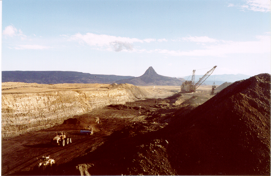
Both are common and I have provided images previously. Here is a picture of a coal mine in New Mexico. On the left wall, at the very left edge of the image, there is a lozenge shaped body of sand with large scale cross-beds indicative of a sand bar. These bodies, when mapped, follow a narrow band that looks for all the world like a channel cutting through most coal fields. Some of them in Illinois can be traced for tens of miles. It is important to understand these things because they present certain hazards to mining.
The next image is a cross section of the Paradox Basin in which sedimentary fans continually feed into the basin from highlands to the right of the diagram.
In the lowest part of the basin (part of the landscape), out beyond the clastic fans, you can see that salt was being deposited at the same time. Even farther out to the left, you get into marine sediments of the type that you commonly refer to ... some of the Grand Canyon formations. ETA: You will note the relatively rapid lateral changes of depositional environment typical of terrestrial sedimentation; in other words, NOT the continental scale geological formations. Edited by edge, : No reason given. Edited by edge, : No reason given.
|
|||||||||||||||||||||||||||||||||||||||||||||
|
edge Member (Idle past 1736 days) Posts: 4696 From: Colorado, USA Joined:
|
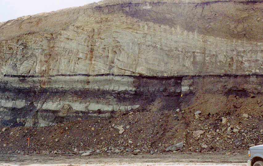
Here is a better image of a sand bar in a coal field setting. These rocks are late Cretaceous to Paleocene in age.
Note the cross bedding dipping to the right. This indicates that the streams was flowing toward the viewer or away (can't tell from here). The stream cut down to the thin coal layer (probably a bunch of organic debris at the time) as it meandered toward the right. The process was terminated as this meander was abandoned and the channel was filled by mud and silt shown in the upper right of the image. So, the sand bar was frozen in time until exposed by mining millions of years later. The image has a lot more information in it that could be discussed, but that should do it for now.
|
|||||||||||||||||||||||||||||||||||||||||||||
|
|
Do Nothing Button
Copyright 2001-2023 by EvC Forum, All Rights Reserved
![]() ™ Version 4.2
™ Version 4.2
Innovative software from Qwixotic © 2024