|

Understanding through Discussion |
|
|
Register | Sign In |
|
QuickSearch
| Thread ▼ Details |
|
Suspended Member (Idle past 1474 days)  Posts: 35298 From: Nevada, USA Joined: |
|
Thread Info
|
|
|
| Author | Topic: Motley Flood Thread (formerly Historical Science Mystification of Public) | ||||||||||||||||||||||||||||||||||||||||||||||||||
|
Percy Member  Posts: 22505 From: New Hampshire Joined: Member Rating: 4.9
|
Faith writes: Percy, you'll just say I'm complaining again etc etc etc,... But you are complaining again. For the umpteenth time instead of addressing the issues raised about your ideas you're complaining about what other people are doing wrong that is making it impossible for you to actually address the issues. You're not fooling anybody. No one believes you have answers that you'd readily provide if it weren't for the nefarious other participants making things impossible for you. You're just doing what you always do, ignoring posts, ignoring most of posts that you do reply to, changing your positions, and making up your own terminology. This last is a particularly significant source of confusion. No one likes diverting discussion into definition of terms, so when you say something like "strata erode as a block" most people just think, "Well, all I can tell is that she's talking about erosion, so I'll reply based on that." This sets the stage for you to later complain that no one is making an effort to understand what you mean. So I *have* been making a significant effort to understand precisely what you mean, and you have been ignoring me tooth and nail. It's probably at least a couple hundred posts since you started saying that strata erode as a block, I've been asking what this means all during this period, and you still haven't answered. It's just another bit of terminology you've made up that has no meaning but that for you causes the "makes sense" light to go on in your head when it actually makes no sense at all. Now maybe I'm wrong. Maybe it makes perfect sense. If so then would you or anybody please explain what "strata erode as a block" means and why it supports your claims of continuous uninterrupted deposition. My guess is that for you "strata erode as a block" is just a shorthand way of saying that strata cannot be eroded until all the strata of a stratigraphic column have been deposited (are "in place" in your lingo). If that's correct then this has already been falsified many times. Evidence of erosion at strata contacts is ubiquitous.
...but I really can't cope with your voluminous posts... I address every point or claim in your posts that is incorrect, and I repeat points that you've ignored. As you repeat your errors and I (and others) try to introduce more and more evidence, and as you ignore more and more points that I'm forced to repeat, naturally my posts get longer. Respond to the points in meaningful ways using terminology people understand and don't violate well established geological principles or known physical laws and the responses will become much shorter, turn to agreement even. Because it doesn't often happen I also try to note where you've said something true, but the common case is that practically every sentence in every one of your posts is wrong is some way, so of course anyone trying to be thorough, instead of just picking out the most egregious or most on-topic issues, is going to end up responding at length.
...which come days after my own and others' on that subject in many cases,... I regret not being able to keep up with the pace of your threads, but I try to evidence and fact check and conform to geology in everything I say. I encourage you to do the same. Also, sometimes I have insufficient time to keep up but feel an obligation to address every reply to me. When someone takes the time and trouble to convey information to me I feel it is incumbent upon me to show respect for that effort by making my own effort to understand what they say, to research what they said that I don't understand or (in your case) don't believe is true, and then respond meaningfully. I realize I'm doing a lot of patting my own back here, but those are my goals. How well I achieve them is for others to decide.
...after the thread has moved on to other things,... At least in this thread, it doesn't seem to have moved on to other things at all. All the issues from a few days ago were still in play.
...and then you really do make some very strange misinterpretations of what I was saying,... This is one of your constant complaints, that people don't understand what you say. And it's true, they don't, but that's your fault. You invent your own terminology, you eschew standard terminology, you use pronouns and words like "things" and "stuff" all over the place, and most of your ideas violate geological principles and known physical laws. In other words, you're rarely able to give a coherent and comprehensible account of events that is actually possible. This results in a variety of interpretations depending upon how people interpret your ambiguities and impossible claims.
...even keep insisting on them after I've answered them,... Someone who responds to only 52% of messages posted to her, and who ignored most of the points made in messages she does respond to, has little credibility claiming issues have been answered. Naturally you *have* attempted to address some issues, but never successfully. In fact, your responses usually just generate more questions because you often introduce additional impossible claims.
...which makes it all the harder to try to answer you. Since the only acceptable answers have to be intelligible and follow established geologic principles and known physical laws, and since none of your answers fulfill those criteria, it will always be very hard for you to answer your critics. Making things up off the top of your head simply because of ignorance and a willingness to ignore well established knowledge is not going to fly.
Here and there you raise some interesting points but I feel like if I answer them I'd be asking for another thankless round of miscommunication and I'm not up to it. Quite obviously you're not up to it. Despite all the feedback you've received over the years your ability to support your claims in any scientific, rational or logical way has not improved one whit. That's because you subordinate evidence from the real world to your eclectic interpretation of an ancient myth. This makes it impossible for you to fulfill your goal of developing naturalistic explanations for a supernatural event. You can't be scientific if you ignore every piece of science that contradicts your interpretation of your book. --Percy
|
||||||||||||||||||||||||||||||||||||||||||||||||||
|
Percy Member Posts: 22505 From: New Hampshire Joined: Member Rating: 4.9 |
edge writes: I'm sure that most of us find Faith's casual dismissals and misplaced air of superiority to be offensive. I think for me it's more a sense of incredulity that views so obviously wrong could be so persistently resistant to facts from reality.
However, I think that we need not worry. Such distortions of reality are self-defeating. No one is going to be convinced by such anti-science denial that we see here, and if Faith wishes to cling to a distorted reality, we have the satisfaction of knowing that she represents but one person. An oddity, not a great hindrance to knowledge. My concerns are based upon the effect of such thinking on science education. I agree that Faith's impact on science education is minimal to non-existent - even creationists can detect those parts of her ideas that are wildly impossible. The benefit of discussion with Faith is the honing of ones skills at countering fantasy-based thinking with reality-based evidence and reasoning, and the recognition that even that has only mild chances of success. You can send a flat-earther to the moon and back but he'll still believe the Earth is flat. --Percy
|
||||||||||||||||||||||||||||||||||||||||||||||||||
|
Percy Member Posts: 22505 From: New Hampshire Joined: Member Rating: 4.9
|
Faith writes: Please explain why you think none of the contacts between strata at the Grand Canyon contain evidence of erosion and/or missing spans of time?
I believe I've not said NONE of the contacts, but VERY FEW, VERY VERY VERY FEW, and I believe they can be explained as having occurred after the strata were deposited.
But we've presented evidence on numerous occasions of erosion at a number of these contacts. I'll not repeat the evidence again unless you request it. So of these unconformities that geologists believe have evidence of erosion, which ones do you believe they're wrong about and why? You can find the information about the unconformities at the USGS site, for example, for the base contact of the Kaibab Limestone it says:
quote: Back to your message:
As for missing "time," no, missing layers that often occur at a location but didn't in a particular case, yes. As Edge asked, how many exceptions do you believe are necessary to falsify your views?
Why do claim that strata deform as a unit but contradict yourself and claim that the stack of Supergroup and Paleozoic strata did not deform as unit, with only the Supergroup layers tilting but none of the layers above? Again the point is that deformation or erosion as a unit is just one of the many ways it can be shown that the Time Scale is false,... This isn't relevant to the question, but it's worth noting that you still haven't defined what "erosion as a unit" means. There is no logic to the claim that what happens to strata after they're deposited, whether it be deformation or erosion, has anything to do with how they were deposited, continuously or not.
...and yes of course it's another way of saying all disturbances occur after all the strata were in place and no you have not proved anything to the contrary, what a silly thought, it's obvious in a million places. You've never defined what "in place" means. Strata do not move around with respect to adjacent strata except through faulting. You can tell by everyone's responses to you that we all believe that "in place" means the strata have been deposited and exist, which makes your statement self evident and incredibly obvious, i.e., something there is no need to say. Of course strata cannot be deformed or eroded until they exist. So are you really just continually repeating something very obvious, or are you trying to make a different point? If the latter then it should have been obvious to you some time ago that your point isn't getting across. If you truly mean something different from what everyone thinks you mean then you need to find a different way to say it.
Actually the Paleozoic strata deformed as a unit in that they all rise over the uplift. The Supergroup deformed in two blocks of strata. Since I think all these things occurred at the same time in a sense the whole thing deformed as a unit. But they did not deform as a unit. Deforming at the same time is not synonymous with deforming as a unit. You're abusing the English language. The Supergroup deformed completely independently of the Paleozoic layers. That is the opposite of deforming as a unit. This calls into question your definition of "deformed as a unit." When you say the Smith cross section of layers tilted as a unit then we all agree with you, because all the evidence indicates that they did, indeed, tilt as a unit, i.e., that they tilted at the same time in the same way in response to the same forces. But when you use the same term of "deformed as a unit" for the Supergroup/Paleozoic stratigraphic column where part of it tilted and part of it didn't then obviously they did not tilt at the same time and did not experience the same forces.
--->>>>But if you might remember, I also said that angular unconformities are the single exception to this rule of deformation as a unit which would resolve your "contradiction." . And I questioned this when you first mentioned it in my Message 187 - you didn't respond. This is as good as no definition at all. It likes saying, "Strata tilt as a unit except where they don't." So now you've got two different and inconsistent definitions for "deformed as a unit," one that makes no sense, and another that is useless. You need to come up with a third definition, one that is useful and makes sense. --Percy Edited by Percy, : Grammar.
|
||||||||||||||||||||||||||||||||||||||||||||||||||
|
Percy Member Posts: 22505 From: New Hampshire Joined: Member Rating: 4.9 |
Moose writes: Now, per your "created according to the principles of Walther's Law". I still resist invoking Walther's Law as being a process. But I didn't call it a process. I had you in mind when I said "created according to the principles of Walther's Law".
Recently I discovered a better terminology:
https://en.wikipedia.org/wiki/Deposition_(geology)#Null-point_hypothesis quote: quote: This might be helpful detail for someone who already understands Walther's Law, but I don't it it's a helpful avenue for explaining Walther's Law.
Now, Faith's muddled scenario apparently involves sediment being eroded off the continents and being deposited at ocean shorelines. This isn't recognizably, at least to me, a claim Faith has ever made. Let me make sure I'm interpreting this correctly. Does this say that the rains fall upon and denude the continents, and that then this sediment laden water flows off the continents and deposits its sediment load at the coastlines? If so then I don't think Faith has ever said this. Or were you just trying to boil Faith's scenario down to a single sentence?
While I envision that the results of the Faith variation of the mainstream concept would look substantially different from the above graphic, I think that Walther's Law would still be valid. It's still a migrating environment. I understand you're trying to lend Faith a hand, and I respect that, but this seems to adopt a Faith strategy, employing terms inappropriately, in this case "migrating environments." Could tsunamis really be described as migrating environments? A quick Google revealed nothing online where Walther's Law was discussed in the same context as tsunamis or waves or inundations. But migrating depositional environments aside, Walther's Law is about vertical strata that were originally deposited in laterally adjacent environments, and Faith's scenario has no laterally adjacent environments.
Faith also invokes large sediment amounts being stirred up in the ocean basins and somehow being washed up into the near shore environment. While there are all sorts of problems with this scenario, I visualize that such might result in a sediment size distribution that goes from coarse to fine from seaward to landward (the opposite order of the "Walther's Law" model). I see this because of the sediment deposition fining as you get further from the ocean basin sediment source. Right, but this is just another way that Faith's scenario requires sediments to behave in impossible ways. You described Faith's scenario as "sediments...somehow being washed up into the near shore environment," but she's actually been specific about this, saying that it involves consecutive waves, each depositing a sediment load. She also says that eventually the water level rises enough to completely cover the continents, at which point there are, of course, no more waves, but deposition of sediments suspended in the waters continues. But as for Walther's Law, none of this involves laterally adjacent depositional environments.
So, the final stratigraphy might be some sort of hybrid of the land sourced sediment model and the ocean basin sourced sediment model. I would expect that even such hybrid would still result in a Walther's Law relationship. I don't see how that's possible.
Now about a bit of Percy statement from message 556:
Percy, message 556, writes: The ocean floor has not dropped. Surveys of the ocean floor after WWII in order to aid submarine navigation revealed a great deal of information about mid-oceanic ridges and sea floor striping and so on, but not an ounce of evidence for dropping sea floors. I wasn't thinking of uplift and subsidence of sea floor but of the absence of evidence for dropping sea floors 4500 years ago (the total Faith scenario is for the sea floor to both drop and rise because the source of extra water was a reservoir of water beneath the sea floor, but she only mentioned dropping sea floors in the message I was replying to). Such a dramatic worldwide event (sea floors dropping several miles over 40 days and nights then gradually rising) would be the single most evident seafloor feature, yet there's no sign of it. But this idea of a reservoir of water beneath the seafloor doesn't really work if the seafloor has to drop for the water to emerge and then later rise for the water to disappear beneath it again. That wouldn't change sea levels. For the sea level to rise the reservoir of water would have to emerge from beneath the sea floor, but the sea floor couldn't drop. That would leave a vacuum behind, another absurd possibility. I think someone might have mentioned the vacuum issue recently, maybe Edge. Plus we know there's no reservoir of water beneath the seafloor.
As I understand it, the great sea transgressions and regressions in geologic history were indeed largely caused by ocean floor rises and falls. This is the reality that ties into the "catastrophic plate tectonics" fantasy. Over the years I've tried and failed to find good (or even mediocre) internet literature on this process. Perhaps to be discussed further in later messages. This would be really interesting to discuss, but I don't think it's related to anything Faith is saying. --Percy
|
||||||||||||||||||||||||||||||||||||||||||||||||||
|
Percy Member Posts: 22505 From: New Hampshire Joined: Member Rating: 4.9
|
Faith has just replied to a 608 word message with 8 words. She has no answers for the points raised, which were:
The reality is that the Supergroup layers and the Paleozoic layers were never part of a single stratigraphic column of horizontal layers. The Supergroup layers were deposited first in marine environments, then uplifted and exposed at the surface, tilted, then eroded flat, followed by the deposition of the Paleozoic layers atop them, the tilted contact forming an angular unconformity. --Percy
|
||||||||||||||||||||||||||||||||||||||||||||||||||
|
Percy Member Posts: 22505 From: New Hampshire Joined: Member Rating: 4.9 |
This is a longer post than you usually write. 5 of your last 15 posts were one line, another was 2 lines, and except for this long post the rest seemed to range from 5 to 10 lines. Even before reading them I'm not going out on any limb if I predict that at best you just repeat your basic positions that have already been shown wrong, and at worst you just ignore what people say to repeat your old talking points. But since Edge and PaulK replied so briefly I'll attempt a longer response that touches on each of your points.
We all know there is copious evidence of unconformities, and it is plainly described in many places on the Internet.Probably the best summaries are at the USGS site, a good starting point is Stratigraphy of Grand Canyon National Park, and from there you can find descriptions of all the strata, including of the unconformities. Just click on any of the layers in the diagram to get to the corresponding page for that layer. The unconformities are described well enough to provide a good idea of what kind of erosive features are present. The African Rift is a result of a continent splitting event that is taking place now - it is not something that "occurred" - it is still happening now. You can't make up your own reality. Claims that are made up and completely unsupported by evidence need no more rebuttal than to note that they are made up. A couple of your paragraphs are so wrong they have to be addressed almost sentence by sentence. Your mistake density can become impressive, and such is the case here. The real world is conveniently available 24/7 for fact checking, you should make use of it more often. Making up stories is fun and easy, but it's no substitute for fact-based reconstruction of past events. Suffice to say that the current understandings of things like the formation of the Appalachians and the breakup of Pangaea are based upon evidence. You do mention evidence, like faults and angular unconformities and volcanic basalts, but they are mere decoration for your story telling that you never connect to your claims. Because I plan to address angular unconformities in a future post, I won't respond to your comments on them in this post.
Faith writes: And also, PLEASE explain the unconformities to us. Certainly. They are contacts between layers that according to standard Old Earth Geology were originally occupied by a layer/time period, which can often be found in other stratigraphic columns in the vicinity. There isn't one iota of physical evidence of any former presence of such a layer where the "unconformity" supposedly exists, it is entirely an assumption based on the Geological Time Scale. In physical reality they never existed, no layer was ever deposited there. This makes no sense. If the strata is rock (and if we're talking about the strata in the walls of the Grand Canyon then almost all the strata are sedimentary rock) then there must have been overlying layers providing sufficient pressure to turn the loose sediments to rock. And if the top contact of that strata has evidence of erosion then it must have been exposed at the surface, which could only be possible if the overlying strata were first eroded away.
The splitting of the continents was a worldwide event, that's what I'm talking about. Please document this. Is the East African Rift part of that break-up? No idea, but if it's a similar event and it occurred at the same time as part of the same tectonic movement I suppose it was. You should have looked up "East African Rift" before replying. The East African Rift is not something that "occurred," as you described it, but something that is occurring as we speak, and has been occurring for quite some time. The rifting began some 20 Ma, and eventually it will become a mid-oceanic ridge from which new sea floor will spread to create a new ocean basin. The African plate will split into two new plates that have already been named, the Somali and Nubian plates.
A lot of tectonic bashing and crashing going on. There's no such thing as "tectonic bashing and crashing". Tectonic movements occur very slowly at the rate of inches/year at most. These slow motions can become apparent when tectonic forces build up stress along existing fault lines or create new fault lines, causing sudden slips that result in earthquakes, such as along the San Andreas fault in California or the North Anatolian Fault in Turkey. Volcanos can be another manifestation, though produced in a less direct way.
The breaking up must have been fairly jolting,... The earthquakes and volcanos - sure.
...but then there was the subduction on the west side of the Americas that pushed up mountains etc. I happen to think it occurred in conjunction with the beginning of the receding of the Flood, because of the effects like the cutting of the Grand Canyon and Grand Staircase and the other massive erosion events in that area; and the dramatically deformed rocks in other places would be a natural result of such a tectonic bashing. Edge replied to this this way:
edge writes: So, the deformation occurred before the Tertiary rocks were deposited. That's an important issue, and I'll address your response in a minute, but there are other important issues. What makes you think Pacific Plate subduction beneath the North American Continent, a process ongoing for millions of years, could be linked to erosion caused by receding flood waters. It is true that deformation can result from plate collisions, what you're calling "tectonic bashing," but that is not the only result of tectonic forces. For example, the East African Rift is undoubtedly the result of tectonic forces, but plates are being pushed apart rather than colliding. This pushing apart is also deforming strata.
No, the conventional timing of the breakup of Pangaea is incorrect, as evidenced by the continuous laying down of the strata up to Recent time,... This is an interesting statement for you to make, although "Recent time" is ambiguous. Assuming you mean roughly the present or at least sometime within the last couple hundred years, you seem to be saying that sedimentation and strata formation continued after the Flood but recently ceased. That of course is not true. We observe sedimentation occurring today, and there is no doubt it will continue on into the future. The products of erosion have to go somewhere, and the mechanisms of transport pretty much guarantee that the vast majority of sediments eventually end up on pond, swamp, lake, lagoon and sea bottoms. But how does continuous sedimentation up to "Recent time" provide evidence for when Pangaea broke up? The dating of sea sediments from ocean cores tells us that the bottom layers from the oldest parts of the Atlantic, such as off the Maine coast, are around 175 million years old. The dating is mostly done through magnetic striping.
...as shown on the Smith cross section of England. Had the strata since the Jurassic not been deposited at the time of the breakup of Pangaea,... Pangaea's breakup occurred over a long stretch of time from around 175 Ma to around 60 Ma. The end of the Jurassic does roughly correspond to the beginning of the breakup of Pangaea, so as long as one isn't too picky about when your "strata since the Jurassic" began being deposited, it is simply a truism that after the Jurassic strata were deposited during the period of Pangaea's breakup. But since the conclusion of Pangaea's breakup 60 Ma strata have continued to be deposited.
...it would not be deformed in the same pattern as all the rest were,... What is this "same pattern" that you're referring to, what strata does the phrase "all the rest" refer to, and why do you think they're similar to the strata in the Smith diagram?
...because that deformation is best explained as the result of the tectonic event we are discussing which came after all the strata were in place. This is incorrect. Angular unconformities around the world are the result of tectonic forces tilting strata, and strata have been tilted by tectonic forces during all different time periods.
In fact the recent strata in the UK would probably have been laid horizontally on top of all the other strata if the conventional timing was true because that's the way those strata were probably originally deposited. It's impossible to know what recent means to you since to you everything is geologically recent, but in general sediments are deposited roughly horizontally and always on top of whatever is there. It has nothing to do with whether "the conventional timing" is true - it's just something that's been understood since Steno.
Instead the pattern of deformation across all the time periods shows that the continents did not split until after all the strata were laid down. The mere existence of angular unconformities is proof that deformation occurred before all strata were deposited.
The strata in the Grand Staircase area demonstrate the same thing: all in place up to Claron before tectonic disturbance formed the GS cliffs and the GC. As has been stated before, the Colorado Plateau has been relatively quiet tectonically for hundreds of millions of years, but not the rest of the world, including the regions immediately adjacent to the Colorado Plateau. In the same way that the moon's lack of rotation held back astronomy by centuries, that the Colorado Plateau is the region where erosion has exposed so much earth history is holding back your own views by centuries. You're focusing all your attention on the Grand Staircase region not because it's typical of world geology but because that's where the strata are visible. You're like the drunk looking for his keys under the lamplight because that's where the light is, not where he dropped them.
Oh it does conform to the facts. It's been explained many times how your views not only don't conform to the facts, but are often contradicted by them. Your reaction is to ignore or to simply repeat unsupported assertions as if they hadn't already been multiply rebutted.
So you had the mountains forming in western North America and the continents breaking up in eastern North America. When did the Appalachians form? The continents split between the east coast of America and Europe/Africa of course. I think the Rockies were pushed up as a result of the subduction beneath the west coast of America, but the whole continent was affected, I don't think you can split it between east and west, it all happened at the same time due to the same tectonic event. The evidence we have says that the breakup of Pangaea occurred over a period of about a hundred million years.
The Appalachians of course formed at the same time but the pressure wasn't as forceful on that side of the continent as it was in the west so they are more of a buckling or crumpling of the land than a thrusting up of whole blocks of strata as in the Rockies. The Appalachians can be found in Ireland, so since North America split with Europe very early in the Pangaea breakup the Appalachians already existed when the breakup began. The Rockies came much later with the Laramide Orogeny.
And there was volcanism released as a result of this event too of course, which accounts for the Sierras among other things. If by Sierras you mean the Sierra Nevada range then yes, volcanism played a role in it's formation, but that fact by itself says nothing about when it happened.
The dike at Siccar Point one remnant of it in that area. The magma that reaches all the way to the Claron in the GS is another. Magma doesn't reach as far in the GC because the strata had been washed away above the point where the magma did spill over. The Hurricane Fault and the angular unconformity to the north of it were also the result of this tectonic event, the result of the raising of the land to the south, and apparently a LOT of sedimentary material just sort of fell off the cliff on the north, a lot of it getting washed away by the Flood water as so much of the Grand Staircase was also. Oh there's more... It doesn't matter that there's more, you have no evidence for what you've already said. You've mentioned a bunch of things that exist but provided no evidence for when they happened. The plain fact of the matter is that you're still just making up stories. Usually you just tell your stories and don't mention evidence, and when you do mention evidence it's unconnected to your claims. --Percy
|
||||||||||||||||||||||||||||||||||||||||||||||||||
|
Percy Member Posts: 22505 From: New Hampshire Joined: Member Rating: 4.9 |
Faith writes: If it's invisible it isn't evidence of erosion. It's a pretty solid sign that someone has no response then they post an 8 word response repeating their lame claim to a detailed 538 word message. The evidence for erosion is not invisible. I already excerpted a description of the erosion at the base contact of the Kaibab with the Toroweap. Didn't you read it? Here are the USGS descriptions of other unconformable contacts between strata at the Grand Canyon. You can find the links to this information for each layer at Stratigraphy of Grand Canyon National Park:
Five of these unconformities are erosional - the erosion is definitely visible. Unconformities falsify your idea of continuous deposition, and erosional unconformities are visibly undeniable evidence. Angular unconformities falsify your idea that no deformation of strata occurred until all strata were deposited. --Percy Edited by Percy, : Add entry for Redwall Limestone/Muav Limestone contact.
|
||||||||||||||||||||||||||||||||||||||||||||||||||
|
Percy Member Posts: 22505 From: New Hampshire Joined: Member Rating: 4.9 |
It's sad when someone, either through ignorance, incompetence or design, makes it impossible to move a discussion forward. Such is the case here where you repeat your original argument (and only part of it) from scratch, with no acknowledgement of, let alone any reply to, the rebuttal:
Faith writes: I'm talking about contacts where there is no visible sign whatever of a layer that is assumed to have been there and eroded away based on belief in the Time Scale and not based on actual evidence. Perhaps you'd like to tell us about your "actual evidence," because we've certainly told you about ours, over and over again. When there are no signs of erosion then evidence for unconformities comes from either a jump in time as indicated by indicator fossils, or by actual radiometric dating when possible, or by out-of-sequence strata (e.g., sandstone overlying limestone).
If there is some of that layer present that's a different situation. An exmple would be the Temple Butte Formation, which has an off and on presence between the Muav Limestone and the overlying Redwall Limestone. See the "Muav Limestone/Redwall Limestone" entry I just added to Message 723 upon discovering this information in Wikipedia.
Why are you going on about this? I'm not going on about unconformities with little or no evidence of erosional cutting. Had you read the conclusion of Message 723 you would know that because it notes that five (now six with the additional information I found) of these unconformities are erosional - the erosion is definitely visible. Unconformities falsify your idea of continuous deposition, and erosional unconformities are visibly undeniable evidence. Angular unconformities falsify your idea that no deformation of strata occurred until all strata were deposited. To repeat this in list form to help insure the information gets across this time:
--Percy
|
||||||||||||||||||||||||||||||||||||||||||||||||||
|
Percy Member Posts: 22505 From: New Hampshire Joined: Member Rating: 4.9
|
That you have a complete lack of evidence is made clear when you argue like this:
Faith writes: Nobody has a clue what the preFlood world actually was like so I can't possibly be saying exactly WHAT was ruined,... If you have no clue, no evidence, of what the preFlood world was like, how do you know anything was ruined?
...all I know is that this world looks like a gigantic wreck. The world exists in all states of condition. Here are some particularly nice ones:
What parts of the world look like wrecks to you? Especially the Nevada desert that you criticize has great beauty:
Why do you think the world is wrecked? Is the concept of natural beauty lost on you? I'm lucky - I sit in my family room or study or back porch and look out on a beautiful forest that extends for miles (not without its clusters of houses) with squirrels and chipmunks and turkeys and the very occasional quail and birds and deer and fishers and hedgehogs and snakes and toads and tree frogs and the very occasional bear and changing seasons and snow and sleet and rain. Sometimes during a violent thunderstorm we'll sit on the back porch while the rain pours down amidst cracks of thunder and great bolts of lightning - beautiful and wondrous. Here's the view out my family room window:
Back up your words - show us the view out one of your windows and show us how it's a wrecked world out there. Since you have no idea what the preFlood world looked like, how can you draw any comparison of the world today with the world preFlood?
That's all I'm saying. The strata are a clue to the Flood that did it,... There is no evidence of a global flood in the strata, which appear to be the result of the same geologic processes we see in operation around the world today.
...there is no evidence left anywhere of what the original Creation was really like since all its parts have been scattered. But scattered doesn't mean non-existent. We've explored a fair amount of the world. Don't you think we'd have come across some of these scattered remnants of the preFlood world by now if they existed? --Percy
|
||||||||||||||||||||||||||||||||||||||||||||||||||
|
Percy Member Posts: 22505 From: New Hampshire Joined: Member Rating: 4.9 |
Faith writes: pollen and fossils are evidence of the pre-Flood world. By what logic do you arrive at this conclusion? --Percy
|
||||||||||||||||||||||||||||||||||||||||||||||||||
|
Percy Member Posts: 22505 From: New Hampshire Joined: Member Rating: 4.9 |
Ignoring the rebuttal and simply repeating her original assertion unchanged has become a Faith hallmark. Here we see it again about angular unconformities:
Faith writes: Faith says that units deform as a block, but then breaks her own rule by claiming the layers from the Sixtymile down tilted by themselves independently of the rest of the unit from the Tapeats up. Clearly she has no coherent definition of a unit. Nonsense. You forget I've excepted angular unconformities. Your claim is that strata deform as a unit. But you also assert this sequence of events that contradict that claim:
For example, we have this sequence of strata that form a unit:
Now the strata of this unit from Sixtymile downward tilt, and the layers above it do not tilt. Obviously this falsifies your claim that strata deform as a unit. There's the dictum that you can have your own opinion but not your own facts, and I'd like to add another. You can't reach any valid conclusions without valid logic. --Percy
|
||||||||||||||||||||||||||||||||||||||||||||||||||
|
Percy Member Posts: 22505 From: New Hampshire Joined: Member Rating: 4.9 |
When someone refuses to respond to substance and just makes baseless accusations, that's a pretty strong indication that they have no counters to the arguments. Nothing you say has anything to do with your topic, you're just lashing out at people who are pointing out the problems with your views. Let's examine your content-free post bit by bit:
Faith writes: Well I read enough of your post to know I have no interest in answering any of it. Because why? I responded to most of the points in your long Message 681. Didn't you make these points to see how people would respond? Well, I responded, so why do you have no interest in posting a response back? The answer is that you don't really have evidence or arguments and that you're just playing a game. Distracting attention away from the topic is what you do when your chain of illogic and absence of evidence runs into a yet another dead end.
I'm at the point where I sometimes repeat some things because I don't want them to get lost... Actually, you've been at the point for some years where you're only capable of repeating what you've said dozens of times before, always as if they were new points that had never been rebutted when the reality is that they've been rebutted dozens of times.
...but otherwise disagree with so much of the nonsense...even in the teeth of the craziness here. If what we were saying were truly nonsense then you would show that it was nonsense by showing its lack of correspondence to real-world evidence or the lack of rational arguments. But you can't do that, so you do this instead.
...here I don't have any interest in addressing it any more except for that purpose, to keep certain ideas on the table that I take seriously... Why do you take seriously ideas that have no evidential support? Why are you attempting naturalistic explanations for supernatural events, especially when you have no knowledge of or intuition for science? Even if such were possible, you're precisely the wrong person to be attempting this.
Every now and then I may have something more to say. Well, that's not true. After you successfully derail one line of discussion you always have more to say.
Meanwhile sorry but that's the way it is these days. Your ill behavior spans far more than just "these days." It has been your modus operandi for years. So did you enjoy this little response to your digression from the topic? A response that would never have occurred had you stuck to the topic instead of abusing those you're debating with? Here are the points you didn't respond to summarized in list form:
I predict either no reply, or a reply of one or two sentences per point. --Percy Edited by Percy, : Grammar.
|
||||||||||||||||||||||||||||||||||||||||||||||||||
|
Percy Member Posts: 22505 From: New Hampshire Joined: Member Rating: 4.9 |
Faith writes: An unconformity is a buried erosional or non-depositional surface separating two rock masses How is this a rebuttal to anything I said? I'll once again summarize my points in list form:
I again predict no reply, or replies of one or two sentences per point. I guess another possibility is an off-topic reply about some made-up complaint. --Percy
|
||||||||||||||||||||||||||||||||||||||||||||||||||
|
Percy Member Posts: 22505 From: New Hampshire Joined: Member Rating: 4.9 |
Shouting is never a good sign, usually a strong sign that one finds oneself boxed in:
Faith writes: SHOW ME THE EROSION. PICTURES PLEASE. You've been shown plenty in the past - before I make the effort to dig these images out I would need some substantial assurances from you that you'll respond in an honest fashion and discuss rather than dismiss them.
CLAIMS OF EROSION ARE THEORETICAL AND NOT REAL IN SOME CASES, PERHAPS ALL. So just to be clear, you're saying that all this text at the USGS website is "theoretical and not real":
How are these "theoretical and not real"? --Percy Edited by Percy, : Typo.
|
||||||||||||||||||||||||||||||||||||||||||||||||||
|
Percy Member Posts: 22505 From: New Hampshire Joined: Member Rating: 4.9 |
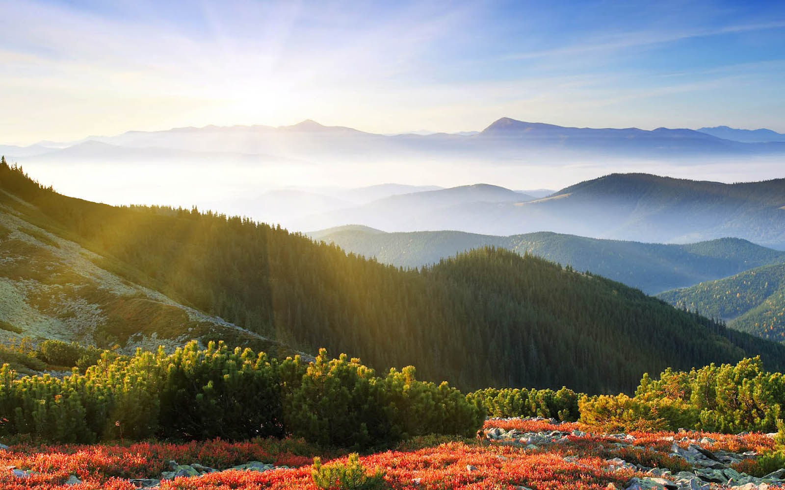
Faith writes: Beautiful foliage covers a multitude of geological sins. What is a "geological sin"? Can I guess that it has nothing to do with science? There isn't a lot of foliage in these beautiful landscapes from your neck of the woods:
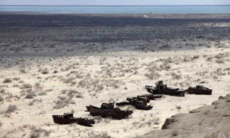
How about some photos from you of the wrecked parts of our planet? Even if you start with the badlands of South Dakota you'll have a hard time making these erosional structures look like wreckage. Want to see something wrecked? Try this image of the Aral Sea:
If you want wreckage just look to man, not nature. --Percy
|
||||||||||||||||||||||||||||||||||||||||||||||||||
|
|
Do Nothing Button
Copyright 2001-2023 by EvC Forum, All Rights Reserved
![]() ™ Version 4.2
™ Version 4.2
Innovative software from Qwixotic © 2024

 (1)
(1)