
|

Understanding through Discussion |
|
|
Register | Sign In |
|
QuickSearch
| EvC Forum active members: 65 (9164 total) |
|
| |
| ChatGPT | |
| Total: 916,914 Year: 4,171/9,624 Month: 1,042/974 Week: 1/368 Day: 1/11 Hour: 0/0 |
| Thread ▼ Details |
|
Suspended Member (Idle past 1475 days)  Posts: 35298 From: Nevada, USA Joined: |
|
Thread Info
|
|
|
| Author | Topic: Motley Flood Thread (formerly Historical Science Mystification of Public) | |||||||||||||||||||||||||||||||||||||||
|
Percy Member  Posts: 22505 From: New Hampshire Joined: Member Rating: 5.4 |
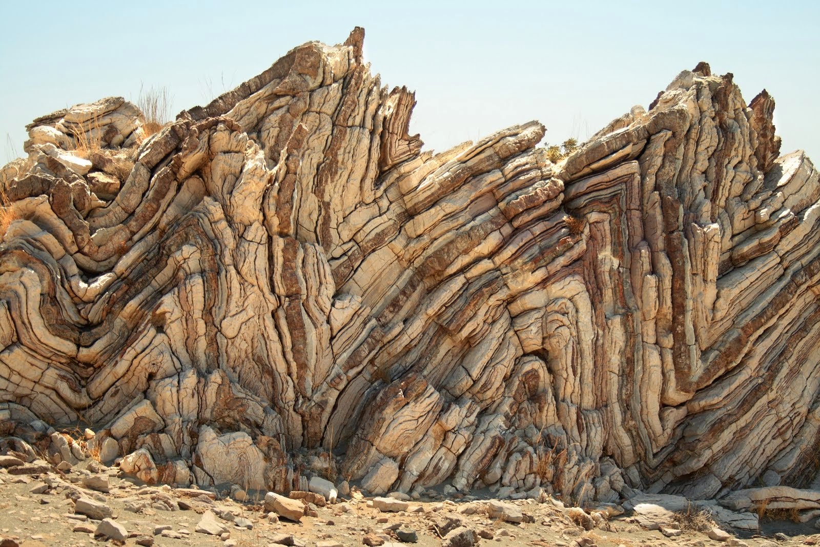
Faith writes: There is one place where the deformation hiccupped... One hiccup would be more than enough to falsify your scenario, but there's more than one. Here are crops into the image of all your hiccups (unconformities caused by surface erosion) that I see going from left to right. I've centered each hiccup, just look in the center of each image:
 That's a lot of hiccups! So tell us, where did all the missing rock go? --Percy
|
|||||||||||||||||||||||||||||||||||||||
|
Percy Member Posts: 22505 From: New Hampshire Joined: Member Rating: 5.4 |
Faith writes: To what 'evidence beneath the surface' do you refer?
The evidence PaulK was referring to. You said that "the evidence beneath the surface occurred after the deformation," presumably about evidence supporting your scenario. PaulK pointed to no evidence supporting your scenario. In fact, the evidence he described shows why your scenario is impossible. So what evidence are you referring to? --Percy
|
|||||||||||||||||||||||||||||||||||||||
|
Percy Member Posts: 22505 From: New Hampshire Joined: Member Rating: 5.4 |
Both PaulK and Edge responded to your post, and you replied to neither one, so here's another response.
Faith writes: There is an overall problem with this example to begin with, that is hard to assess, and that is the kind of deformation it shows, which is very unlike all the other examples I've had in mind. That is, the usual situation is something visible on the surface, such as the tilting or buckling or twisting of the strata along the lines of the photos I posted. If you're talking about these images:
Then the problem is that you interpreted them incorrectly, and they are not the "usual situation" anyway. There is no "usual situation." Every sort of thing that is geologically possible has happened to the Earth and is recorded in stratigraphic columns around the globe. Your idea that a single period of deposition followed by a single period of tectonic activity is responsible for all the world's geology is contradicted by the evidence. What we see recorded in the Earth's strata is impossible in a flood scenario. Your inclination is to ignore the issues raised about your ideas, as you did in this case by not replying to PaulK or Edge, but problems don't go away by ignoring them. In a discussion context it does tend to draw things out since we have to raise and explain the same issues time and again, usually with the same result that you ignore or deny the issues.
The diagram of the UK is entirely different, the deformation is underground and it's hard to figure out what happened to bring it about. The deformations in your images were once underground, too. How do you think such folding occurs if not underground?
Maybe you or edge know but to me it looks like the sagging strata I associate with the Michigan basin and the Gulf coast, where a salt layer seems to be involved. But in this case there is no indication of a salt layer. I don't know why both PaulK and Edge let this stand, but you're wrong all over the place here. Here's the Snowdon/Harwich diagram again:
The strata aren't sagging. As Edge comments somewhere, the strata are tilted upward toward the west due to the Caledonian Orogeny. And about salt layers being involved in that Michigan Basin diagram, we all agreed during that discussion that the salt layers were far too thin to be of any influence:
The sagging of the strata IS the deformation in this case. Assuming you're back to the Snowdon/Harwich diagram, again, no sagging - uplift.
And it isn't like the others I mentioned in that the strata in those cases originate as a vertical unit at one location and then sag and expand as they sag or sink. Assuming you're back to the Michigan Basin diagram again, sagging is not what's happening. It's deposition into stream beds.
The UK example has all the strata in a row across the horizontal level of the land rather than vertically stacked. In Smith's cross section they appear to have been tilted or buckled to all lie in a row. They probably have different amounts of vertical exaggeration and aren't for the same region.
In the other diagram it's basically the same layout with some probably minor differences I don't know how to assess. "Other diagram"? You mean the Michigan Basin one? Something elese?
In any case all the "time periods" are horizontally laid out and all tilted or folded in the same direction which is what strongly suggests the deformation happened to the whole stack of strata at the same time. Repeating your wrong analysis while ignoring the corrections accomplishes what, exactly?
Underground they sag and thicken overall. Again, no sagging, and no general thickening with depth either, though what that would mean in Faith-land God only knows.
They all follow the same basic pattern in parallel. Except that they don't.
That suggests deformation at the same time, as a unit. A stratigraphic column will experience deformation as a unit (though you seem to believe otherwise when it comes to the Grand Canyon Supergroup), but strata that aren't present at the time of deformation will not experience any. Once strata are deposited atop deformed strata then they are of course subject to any future deformations. This is just simple logic. Ignoring it makes you automatically wrong.
What you are focused on seems to me to have occurred at the same time as the deformation or afterward. By "what you are focused on" I assume you're referring to where PaulK called your attention to multiple angular unconformities that could only happen through multiple deposition/deformation/erosion events. The diagram is evidence of these multiple cycles.
The fact that the lower strata are cut off by what you are calling erosion while the upper are not doesn't suggest that the erosion occurred before the upper were deposited. On the contrary, angular unconformities only result from erosion. You quote nothing from PaulK, so are you sure he said the upper strata exhibit no erosion? It sure doesn't look that way to me, so I'd be surprised if it looked that way to PaulK.
That's because they all lie parallel to one another. "They all" (whatever that means) are not all parallel to one another.
Whatever happened to the lower strata had something to do with the sagging or deformation itself. Again, uplift.
And overall we're talking about a whole stack of deformed -- sagged -- strata. And again, uplift.
If the upper layers had been deposited after the erosion occurred to the lower layers, it would be more convincing if they were still straight and flat as originally laid down. It's even more convincing as is because of how clearly it illustrates multiple episodes of deposition/deformation/erosion.
Since they follow the basic sag pattern And yet again, uplift.
...of the deformation it's too much of a stretch to accept your order of events. And yet you have no rationale for your position. --Percy
|
|||||||||||||||||||||||||||||||||||||||
|
Percy Member Posts: 22505 From: New Hampshire Joined: Member Rating: 5.4 |
Thanks for this information. I hadn't considered extension, but that's a fine explanation, too. I'm only objecting to explanations which require rock to disappear.
I spent about a half hour with Google Images yesterday looking for an image showing more of that fold but no luck. I was hoping that if I could see more of what happened to the layers further to the right I could become more certain (or not) of my conclusion. What can be seen in the image is that the layers appear to be stretched by different amounts (because they thin out by different amounts). --Percy
|
|||||||||||||||||||||||||||||||||||||||
|
Percy Member Posts: 22505 From: New Hampshire Joined: Member Rating: 5.4 |
Meant to reply to this earlier, somehow missed it:
Faith writes: No I DON'T doubt that water would be forced out of rocks under compaction for Pete's sake,... Then why do you believe there is such a thing as wet and malleable rock?
...this is just another of your weird misinterpretations. Why do you think it weird to conclude that your belief in wet and malleable rock means you think water isn't "forced out of rocks under compaction?" How could the rock have had the water forced out yet still be wet? By the way (and I also mentioned this in an earlier thread), even the hardest, driest rock does not have zero water content. Granite can be as much as 0.5% water while a very porous sandstone can absorb water readily (some coasters are made of sandstone for just this reason). But anything that is rock already has a very, very low water content, and while water content can reduce rock strength (making it less competent) it will still only crumble, not bend. Rock isn't malleable on the small scales you need where it can somehow be transformed into pieces small enough to be carried off by 4 inches of slowly receding water. I have a ThirstyStone coaster, which is made of an absorbent sandstone. Nothing's been on it for days so it is completely dry. It weighs 161 grams. Now I'm going to soak it in water for five minutes and weigh it again. Okay, I did that, it now weighs 163 grams, so this particular sandstone can absorb 1.24% water by weight. Had I waited longer than 5 minutes it might have absorbed more, I don't know. But I'm holding this coaster in my hands right now and it does not feel wet, and it still feels very, very hard. My attempts to bend it are in vain. Can we put this myth of wet and malleable rock to bed?
I suppose you aren't doing this purposely but I could almost wish you were so there might be some hope that you could sober up and stop doing it. Those of us on the science side wish you could reduce your error rate below 90%. --Percy
|
|||||||||||||||||||||||||||||||||||||||
|
Percy Member Posts: 22505 From: New Hampshire Joined: Member Rating: 5.4 |
You didn't reply to PaulK's response, so I shall respond also.
Faith writes: The hiccup I had in mind had nothing to do with missing rock, it was just that place on the surface where the land makes a dip before resuming the pattern of tilting or slanting together in one direction. This is false. Do I have to quote you from the discussion? The problem for you is the one we've been discussing, the angular unconformities. PaulK called them "cut off" strata - you even asked what he meant by "cut off". I don't see how you could deny that that's what we've been talking about with a straight face. Have some honesty and integrity. I'm frankly stunned, not that you pull this stuff so blatantly and so frequently, but that you apparently think it works well for you. It does not. Your modus operandi is emphatically apparent for all to see. It is not serving you well. Please stop. My images showed you all the angular conformities I could see in the diagram. Each one is something you can't explain, a considerable number of hiccups.
The idea of missing rock is irrelevant to the point I'm making, and this diagram has become way too complex and ambiguous for meaningful discussion. The diagram is no more complex now than when PaulK first introduced it. It was fine for you then, it should be fine for you now. And it certainly isn't ambiguous. You're investing your efforts in trying to find ways to avoid discussion of the issues that have been called to your attention. You should instead be working toward finding explanations that follow the evidence and known physical laws. The diagram:
PaulK's and my points are related and equally relevant. PaulK is making the point that only tilting deformation followed by erosion could have cut off the strata and created the surface for what later became an angular unconformity when deposition atop it occurred. I'm making the point that your claim that deformation cut off the strata would require cubic miles and miles of rock to disappear into thin air. These are the issues you have to address, but you've apparently instead decided to avoid them. --Percy
|
|||||||||||||||||||||||||||||||||||||||
|
Percy Member Posts: 22505 From: New Hampshire Joined: Member Rating: 5.4 |
Faith writes: The monuments exist because they're capped by hard conglomerate rock. The entire valley was once at the same height as the tops of the monuments - the valley was all monument from one end to the other, and the tops of the monuments were valley floor, just much higher than today. Absolutely correct, although the valley floor was probably quite a bit higher than the tops of the monuments we see today. Yes, indubitably true.
Where we disagree of course is that I believe the receding Flood washed away all the sediments originally surrounding the monuments leaving them standing alone. We already know what you believe. What we're discussing with you, or at least attempting to discuss with you, is the evidence you can muster for your position. So far the answer is, "None."
In any case the point I was making is confirmed: Strata laid down followed by erosion. I have the same reaction as Edge, that it seems strange that anyone would feel the need to say this since it would be very strange for strata to be eroded prior to deposition. Maybe you're thinking of strata made of thiotimoline.  But I think maybe you were trying to say something else. Was it maybe that erosion happened not just after the strata were deposited, but after they were buried beneath deposition of more strata? If so then no, that's impossible. Underground water exists in the interstices and pores of rocks. There's no such thing as underground rivers and streams flowing across and eroding buried strata (and we're not talking about karsts). --Percy
|
|||||||||||||||||||||||||||||||||||||||
|
Percy Member Posts: 22505 From: New Hampshire Joined: Member Rating: 5.4 |
Percy writes: Don't faults qualify, in your lingo, as a disturbance? The Hurricane Fault along the western perimeter of the Kaibab Uplift, and the Toroweap Fault along the eastern, occurred during the uplift.
Yes faults qualify as a disturbance, as discussed many times in the past, such as in Message 260 for example where I list it among the effects of the tectonic disturbance I associate with the Kaibab Uplift. That post is a pretty good summary of what I'm arguing here too. That's it? All you can do is confirm that you consider faults a disturbance? Why are you ignoring the rest of my post? In your Flood scenario the Supergroup strata and the Paleozoic strata were originally part of the same block of strata.You say that strata tilt as a block. If this were true (and it is if there aren't additional factors) then if the Supergroup and Paleozoic strata were all present at the time of the tilt then they would have tilted together. Why are you instead claiming the Supergroup tilted separately from the Paleozoic strata? As PaulK notes in the context of your Flood scenario, where the Supergroup unit on the right should have exerted the greatest upward pressure (its rightmost portion) the Kaibab lining the North Rim is actually lower in elevation than further north (further left). If the tilting Supergroup were actually responsible for the uplift then the North Rim would be higher in elevation than further north, but it isn't. Here's the diagram for reference:
Also, since some Supergroup exposures lie outside the Kaibab uplift, we know the Supergroup didn't cause it. For example, Nanoweap and Unkar group strata are exposed well to the west of the Kaibab Uplift, see Figure 5.1 on page 77 of GEOLOGIC STRUCTURE OF THE GRAND CANYON - one of the authors is Dr. Karl Karlstrom from Mod's video. And do you have any comments on this very short (10 seconds) animation of the tilting and eroding of the Supergroup. Just click on the diagram: Tilting, Faulting and Eroding of the Grand Canyon Supergroup --Percy
|
|||||||||||||||||||||||||||||||||||||||
|
Percy Member Posts: 22505 From: New Hampshire Joined: Member Rating: 5.4 |
Faith writes: Unconformities in the sense of nonexistent layers you expect to be there but aren't is totally irrelevant to the point I'm making. If you believe that then you are very confused. Your position is that deposition was continuous, and unconformities are proof that deposition was not continuous, so unconformities are totally relevant.
You see no erosion there either, you just "know" there should be a layer there that isn't there. What do you mean I see no erosion "there"? What do you mean by "there"? I listed at least 9 unconformities:
Some we know are unconformities because of the evidence of erosion, some we know are unconformities because of a discontinuity in indicator fossils. So of these unconformities that geologists believe have evidence of erosion, which ones do you believe they're wrong about and why?
The visible appearance is of a stack of strata with no break there or any kind of sign or indication whatever that something is missing;... We have time and time again described the evidence that gives away when a contact represents an unconformity. And I just described it again above.
...and what I'm saying remains true:... What you've been saying has never been true, so it certainly couldn't remain true, because it has no supporting evidence, is contradicted by much evidence, and often doesn't even obey natural physical laws.
...there are examples galore of whole blocks or units of strata that are eroded or deformed together as a unit. Saying the strata are eroded as a unit is meaningless. The whole Colorado Plateau is eroding as a unit, and that does not make the whole plateau into a single block of strata. Saying that strata deform as a unit makes more sense, but there is still that outstanding question about why you believe the stack of Supergroup and Paleozoic strata didn't deform as a unit. --Percy
|
|||||||||||||||||||||||||||||||||||||||
|
Percy Member Posts: 22505 From: New Hampshire Joined: Member Rating: 5.4 |
You quote nothing Edge said. I have to guess what part you're replying to.
Faith writes: I'm not talking about an unconformity. I thought the erosion referred to the cutting off of the strata to the right. You seem to have forgotten the definition of an angular unconformity. The cut off strata that you just mentioned and that you've been discussing represent an angular unconformity:
The buried dark layer with the circles in it and the lighter colored strata below it tilt upward to the left. Where they truncate at overlying strata is called an angular unconformity. And there are at least 5 other angular unconformities in that diagram, see my Message 617. This happened when those tilted strata were exposed at the surface and were subject to erosion. That the surface of the angular unconformity of the lighter strata tilts downward to the left indicates these strata were once tilted at a greater angle. Later deformation reduced the tilt of all these strata, which is when the darker stratum was eroded and explains whey it wasn't eroded at the same angle as the underlying strata.
If it refers to an unconformity that is invisible then I'm sure you're right. The angular unconformity is obviously not invisible. --Percy
|
|||||||||||||||||||||||||||||||||||||||
|
Percy Member Posts: 22505 From: New Hampshire Joined: Member Rating: 5.4 |
Faith writes: You are going to drive me to an early grave. Not that I'd mind, I'm ready to go. I *am* surprised you're still here at EvC. The pointlessness of endlessly repeating, in effect, "2+2=5" with no evidence or reasoning and tons of contrary evidence and reasoning should have been obvious to you years ago. Just like in this thread, you somehow convince yourself that you're getting by through a combination of inciting chaos, ignorance, ignoring discussion points, and repeating your position endlessly instead of responding to what people say.
...but the deeper the rock the drier it will be by compaction,... Undoubtedly true, but sedimentation doesn't have to be very deep before weight forces out almost all water.
...the higher it is in the stack the more wet and malleable. There is no evidence that anything like wet and malleable rock exists. Any "rock" that is still wet is insufficiently compacted to be rock. If it's still wet then it could be a very viscous sand or silt or ooze, but not rock.
I don't think it would be COMPLETELY dry if under water, however, no matter how much weight was on it. Even in submerged strata water is forced out of the pores and interstices of compacted rock and floats upward in the stratigraphic column because it is both mobile and less dense than the rock. --Percy
|
|||||||||||||||||||||||||||||||||||||||
|
Percy Member Posts: 22505 From: New Hampshire Joined: Member Rating: 5.4 |
Faith writes: I haven't been talking about angular unconformities at any point in this discussion and I didn't know anyone else was either. I find it very surprising that you can't recognize obvious angular unconformities when you see them. How often have you stared at diagrams of the Supergroup angular unconformity at the Grand Canyon?
This thread became one of those familiar EvC nightmares of miscommunication and weird interpretations some time back that I just want out of, period. Why do you continually insist on making up your own terms, like "strata eroded as a block" and "disturbances"? Oftentimes people have to just guess what you mean, and I don't think it's that uncommon for you and someone else to think you're talking about the same thing when you're not. I think if you would adopt standard geological terminology that it would help reduce confusion a great deal. But you ignored all my points. My images showed you all the angular conformities I could see in the diagram. Each one is something you can't explain, a considerable number of hiccups. If you can explain these angular unconformities without invoking underground erosion (impossible) or magically disappearing rock (also impossible) then please explain away. As I said, PaulK's and my points are related and equally relevant. PaulK is making the point that only tilting deformation followed by erosion could have cut off the strata and created the surface for what later became an angular unconformity when deposition atop it occurred. I'm making the point that your claim that deformation cut off the strata would require cubic miles and miles of rock to disappear into thin air. You need to find explanations that are not both geologically and physically (as in laws of physics) impossible. --Percy
|
|||||||||||||||||||||||||||||||||||||||
|
Percy Member Posts: 22505 From: New Hampshire Joined: Member Rating: 5.4
|
Faith writes: The point I'vfe been making for days now is that erosion occurs to stacks or blocks or units of strata and not between layers;... Saying that "erosion occurs to stacks or blocks or units of strata" is meaningless. No buried strata in a stratigraphic column (which is a block of strata in anyone's book) can be eroded. What you should really say is that exposed strata are subject to erosion.
...also that deformation occurs to stacks or blocks or units of strata and not between layers. But you don't think the Supergroup/Paleozoic stack of strata deformed as a unit. Contradictory much? I've probably mentioned this contradiction in your thinking about ten times now, and you haven't responded yet. Inability to answer challenges to your ideas is a key indicator that your ideas are false, or at least that they have serious issues.
Sometimes I forget to say the whole thing which seems to leave it open for you all to think I'm saying something entirely different, which is weird and frustrating but not unexpected. This is because your claims frequently invoke the impossible or magical.
If only I was always able to expect it before I post it but unfortunately I tend to assume a continuity that obviously doesn't exist. I can't believe the queen of discontinuity is raising continuity as an issue. You've responded to less than 41% of the posts to you in this thread, and when you have responded you frequently ignored most of what was said, often instead reexplaining your own position from scratch.
The point of those photos I posted is to demonstrate that the strata were all in place before the erosion or the deformation occurred. Since it has been said at least a dozen times now that it is self-evident and physically required that strata be "in place" (I'm assuming this means they must exist) before they can be eroded or deformed, why are you repeating this yet again? It's bloody obvious that whatever it is you're actually trying to say is not getting across. Find another way to say it. Could I suggest using standard geologic terminology?
Sometimes as in the Smith diagram the whole range of time periods is present and eroded or deformed as a complete block;... The whole range of time periods is not present in the Smith diagram. Did you forget that you switched the claim to be about eras back in your Message 469, and that you don't actually mean "whole range of time periods" because, as you have already conceded, there are missing spans of time. Find a way to say this that actually says what you mean. Stop misstating your own ideas.
...but usually it's a partial stack where the rest of it is no longer present... Well now you're contradicting what you just said about it being "the whole range of time periods". And no, it is not true that "usually it's a partial stack." It is always a partial stack.
...and what is present is eroded or deformed as a unit or block by itself. Again, "eroded as a block" is meaningless. "Deformed as a block," assuming we're talking about a stratigraphic column, is bloody obvious, except for your self-contradictory belief that the column of Supergroup and Paleozoic layers were not deformed as a block.
This demonstrates something really very very simple: that the strata are not time periods. I'm sure there is no one here but you who can follow your logic. And given that your premise is variously meaningless, bloody obvious, or contradicted by yourself, the conclusion could not possibly be valid.
ABE (I'm aware that that last sentence is likely to lead to another flurry of weird ideas, but in this case I think I'll just leave it and try to be entertained by the weirdness). You should base your ideas on evidence and rational thinking and real world considerations (like physics), and you should express them clearly using standard terminology instead of inventing your own. --Percy Edited by Percy, : Fix grammar for clarity.
|
|||||||||||||||||||||||||||||||||||||||
|
Percy Member Posts: 22505 From: New Hampshire Joined: Member Rating: 5.4
|
Faith writes: Oy You just replied to a 265 word message with a single two-letter word. Congratulations, a new record for you. Ignoring issues and problems with your ideas does not make them go away. It's a strong indicator that you cannot defend them, and all it does is force us to repeat the descriptions of the issues. You say that strata tilt as a block, and in your Flood scenario the Supergroup strata and the Paleozoic strata were originally one block of strata. Why do you claim the Supergroup tilted separately from the Paleozoic strata, instead of the whole block tilting as a unit? As PaulK notes in the context of your Flood scenario, where the Supergroup unit on the right should have exerted the greatest upward pressure (its rightmost portion) the Kaibab lining the North Rim is actually lower in elevation than further north (further left). If the tilting Supergroup were actually responsible for the uplift then the North Rim would be higher in elevation than further north, but it isn't. Here's the diagram for reference:
Also, since some Supergroup exposures lie outside the Kaibab uplift, we know the Supergroup didn't cause it. For example, Nanoweap and Unkar group strata are exposed well to the west of the Kaibab Uplift, see Figure 5.1 on page 77 of GEOLOGIC STRUCTURE OF THE GRAND CANYON - one of the authors is Dr. Karl Karlstrom from Mod's video. If, as you claim, the tilting of the Supergroup strata was responsible for the Kaibab Uplift, how do you explain the Supergroup strata outside the Kaibab that caused no uplift And do you have any comments on this very short (10 seconds) animation of the tilting and eroding of the Supergroup. Just click on the diagram: Tilting, Faulting and Eroding of the Grand Canyon Supergroup --Percy
|
|||||||||||||||||||||||||||||||||||||||
|
Percy Member Posts: 22505 From: New Hampshire Joined: Member Rating: 5.4 |
Faith writes: Congratulations again, you've replied to a 238 word message with virtually nothing. Please explain why you think none of the contacts between strata at the Grand Canyon contain evidence of erosion and/or missing spans of time? Why do claim that strata deform as a unit but contradict yourself and claim that the stack of Supergroup and Paleozoic strata did not deform as unit, with only the Supergroup layers tilting but none of the layers above. Is this message short enough for you? --Percy
|
|||||||||||||||||||||||||||||||||||||||
|
|
Do Nothing Button
Copyright 2001-2023 by EvC Forum, All Rights Reserved
![]() ™ Version 4.2
™ Version 4.2
Innovative software from Qwixotic © 2024


 (1)
(1)