|

Understanding through Discussion |
|
|
Register | Sign In |
|
QuickSearch
| Thread ▼ Details |
|
Thread Info
|
|
|
| Author | Topic: Flood not the Cause of the Grand Canyon -- Not a Biased Opinion | ||||||||||||||||||||||||||||||||||
|
peaceharris Member (Idle past 5627 days)  Posts: 128 Joined: |
Percy writes: Most layers were layed down over millions of years at the bottom of shallow seas or close to coastlines, though some layers were deposited while above water. Sea lilies have been found on the Kaibab limestone. Sea lilies usually "remain permanently attached to the ocean bottom."- Bartleby.com: Do you have any evidence that sea lilies are associated with shallow seas and coastlines? Since the Kaibab limestone formation is the highest layer, you can rest assured all layers were once submerged under water.
|
||||||||||||||||||||||||||||||||||
|
peaceharris Member (Idle past 5627 days) Posts: 128 Joined: |
The above image is taken from Rockhounds.com Since all layers are very horizontal, we can conclude that the layers were formed in very calm conditions. This probably happened when the waters were receding... roughly the same time when Noah let out the bird from the ark. The more dense and larger particles would have sunk first, forming the bottom layers, followed by the lighter and smaller particles. You can see that the Toroweap formation is covered in vegetation in some places and bare at other places. This is due to erosion in my opinion. So the fossils that are found in the Toroweap formation may have originally been in the Kaibab plateau before it eroded. "About 45 earthquakes occurred in or near the Grand Canyon in the 1990s. Of these, five registered between 5.0 and 6.0 on the Richter Scale. Dozens of faults cross the canyon, with at least several active in the last 100 years" - quote fromPage not found – BiologyDaily.com In other words, analysing the fossils and rocks from exposed layers may not be very accurate This message has been edited by Admin, 05-04-2005 08:36 AM
|
||||||||||||||||||||||||||||||||||
|
peaceharris Member (Idle past 5627 days) Posts: 128 Joined: |
edge writes: First, there are whopping cross-beds in the Coconino that tell us the medium was flowing quite rapidly. Please give me a link with a photo to support your assertion. Based on my observation of the photos of grand canyon, I haven't seen cross-beds. The strata are horizontal. Take a look at the following aerial view:http://cs.anu.edu.au/...allery-11/4x6/grand-canyon-1999a.jpg
|
||||||||||||||||||||||||||||||||||
|
peaceharris Member (Idle past 5627 days) Posts: 128 Joined: |
Percy writes: You are correct that the larger and denser material is the first to fall out of suspension. This is more strong evidence against a flood scenario, because layers of large particulate matter are interspersed with layers of small partculate matter. For example, the rough sandy limestone of the Kaibab layer is nearly a half mile above the fine-grained Redwall limestone.
CanyonDave.com is for sale | HugeDomainsCanyonDave.com is for sale | HugeDomains The deep red color underneath the Coconino sandstone has been attributed to iron oxide. This clearly proves some sorting mechanism. Most probably, the particles with iron were denser. Is it possible to determine the size of the particles when these layers formed? When you say 'rough sandy limestone ' and 'fine-grained Redwall limestone', are you referring to the size of particles observed today, or are you referring to the size of particles during the time of formation?
|
||||||||||||||||||||||||||||||||||
|
peaceharris Member (Idle past 5627 days) Posts: 128 Joined: |
roxrkool writes: And unless the rock has been sigificantly altered in any way, it also generally represents grain sizes of particles at the time of deposition. edge writes: Yes, yes and no. However, the size today may be, and usually is, the same as the size at deposition. And if the sizes changed there would be some evidence such as cataclasis or augmentation. I believe the sizes of rocks we see at the grand canyon have been greatly altered. During the time of formation, these particles would have been much smaller. Solidification of these rocks are like forming cement by drying away the water. This message has been edited by peaceharris, 05-05-2005 05:02 AM
|
||||||||||||||||||||||||||||||||||
|
peaceharris Member (Idle past 5627 days) Posts: 128 Joined: |
First, I think you mean the sizes of the grains IN the rocks, not the sizes of the rocks themselves, correct? I am neither interested about the sizes of grains IN the rocks as seen today, nor am I interested in the sizes of rocks as seen today. I am interested to know whether it is possible to determine the sizes of particles at the time of sedimentation.
If you took 2 pieces of rock from the Coconino sandstone and hermit shale, would you be able to tell me the size and density of particles at the time of formation?
Second, what evidence do you have that suggests the shale (clay particles are <0.04 mm) within the Hermit Shale were smaller? Also, what evidence do you have that the quartz grains in the Coconino Sandstone were smaller? "By compaction and cementation, gravels became conglomerates, muds became shales, sands became sandstones, and lime sediments became limestones. " -quote fromPage not found, Kentucky Geological Survey, University of Kentucky I think it is plain common sense to believe that the size and density of the particles observed today is not what it was at the time of formation.
Third, what evidence do you have that the rocks have been greatly altered?
I think that mainstream geologists would agree with me that the rocks have been greatly altered.
|
||||||||||||||||||||||||||||||||||
|
peaceharris Member (Idle past 5627 days) Posts: 128 Joined: |
Unless these rocks have been subjected to some very intense alteration, which the Coconino Sandstone and Hermit formation have **not**, the sizes and density of the particles in them would the same as when they were deposited. OK. Eventhough clay is composed of smaller particles than sand, it is still possible for sea water to sort sand and clay such that clay is below: "Individual clay particles are always smaller than 0.004 mm. Clays often form colloidal suspensions when immersed in water, but the clay particles flocculate ( clump ) and settle quickly in saline water"-quote from Not Found ~ New Jersey Scuba Diving
|
||||||||||||||||||||||||||||||||||
|
peaceharris Member (Idle past 5627 days) Posts: 128 Joined: |
Bill writes: So what? Even though clay might be flocculated, individual particles, because of their high water content are less dense than sand. Thus, their settling velocities will be still significantly less than all but the finest sand. As a result, it would be completely and utterly impossible, as you falsely claim, for flocculation to explain the occurrence of clayey sediments below the sandy Coconino Sandstone. "As mentioned, individual clay particles remain in suspension in freshwater due to their small size and surface charge. When they enter saltwater, however, their surface charge diminishes to no charge, then crystallization forces take over and the clay particles clump together (= they flocculate). Once enough flocculate so that the particle size is large enough so that they can settle out, they fall to the bottom. This is termed salting out. For this reason, the prodelta (that place where the river flow first hits the sea) is virtually solid clay, ... "- quote from Page not found | Loyola University Center for Environmental Communication From the following website , I obtained the densities of various sands and clays (in kg/m3) Clay dry excavated 1089Clay wet excavated 1826 Clay dry lump 1073 Clay fire 1362 Clay wet lump 1602 Clay compacted 1746 Sand wet 1922Sand wet packed 2082 Sand dry 1602 Sand loose 1442 Sand rammed 1682 Sand water filled 1922 Sand with Gravel dry 1650 Sand with Gravel wet 2020 In general, sand is more dense than clay. But according to Stokes' law, settling velocity also depends on particle size. So after flocculation, the size factor is dominant. regards,Harris ps: It is not possible for me to reply to every point that you are making since it takes fairly long time to search for the answers.
|
||||||||||||||||||||||||||||||||||
|
peaceharris Member (Idle past 5627 days) Posts: 128 Joined: |
Percy,
Thank you for your kind words. I really appreciate it. Now let's discuss the time taken for the canyon to form.
Percy writes: If the layers of the Grand Canyon were really only 5000 years old, then the time available for the Colorado to form the Grand Canyon is far, far too short. To mention just two problems: a) The reason the sides of the Grand Canyon are sloped is because of slope retreat. As a river carves down through a landscape, the sides that are exposed gradually erode away from the river. Canyons formed in short periods of time like 5000 years have vertical sides. Since the Grand Canyon's sides are sloped, it must have taken considerably longer to form, millions of years. b) The reason the Grand Canyon cut so deep is because of gradual uplift of the region. As the region gradually increased in elevation the Colorado cut more and more deeply into the land. Had the elevation increased rapidly, say in 5000 years or less, the Colorado would not have had time to cut through the land, and it's course would have instead been diverted in another direction.
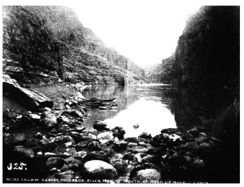
Griffiths et al. (1996) published a report entitled Initiation and Frequency of Debris Flows in Grand Canyon, Arizona They compared 478 photographs taken since 1872, and identified geomorphic changes that indicate the occurrence of one or more debris flows during the time interval separating the photographs. They concluded that "geomorphic change in Grand Canyon is largely catastrophic in nature, especially on a decadal time scale, and changes to debris fans resulting from debris flows are usually obvious."
Photos taken from METHODS Based on this, we need not be surprised that the canyon could be formed in a period of a few thousand years.
|
||||||||||||||||||||||||||||||||||
|
peaceharris Member (Idle past 5627 days) Posts: 128 Joined: |
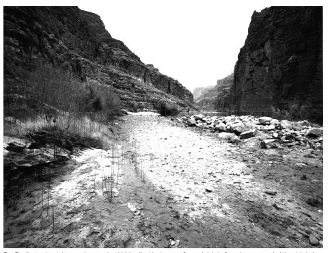
Referring to the photo taken in 1992, the authors wrote, "Several debris flows have aggraded the debris fan, including a large one that deposited the prominent levee at right between 1940 and 1965"
This debris comes from the steep cliff at the right of the photo. The time difference between those 2 photos are 100 years and there has been ~4500 years in my opinion since the flood. If we multiply that debris by 45X, we can roughly explain the erosion of the steep right cliff.
|
||||||||||||||||||||||||||||||||||
|
peaceharris Member (Idle past 5627 days) Posts: 128 Joined: |
roxrkool writes: Peace, you haven't actually shown us any evidence for the canyon getting deeper, just wider. In fact, what you HAVE shown us is a shallowing of the canyon. Both deepening and widening are related. The rain causes erosion of the cliffs. Temporarily, the debris may cause shallowing since it just fell off. But as the fast river flows, it will carry with it the debris which just eroded, and cause some additional erosion along the river, causing deepening.
In YEC theory, how would a river system cut meanders into bedrock and what is the impetus leading to the erosional system seen at the Grand Canyon? Why should meandering be a problem to YECs? If there is rain, a river must form to take the water to the ocean. The river will initially take on a random path, but after the initial river has formed, that would be the easiest path for additional rain water to take. Let's just discuss the time frames involved and whether there was a flood which formed the initial layers.
Mainstream geology says there was a vast river system in the area, cutting across a flat plain where the meanders were formed. Later, the plateau was uplifted and through a series of stream capture and catastrophic events, the Grand Canyon was eventually formed. In the event of the plateau being uplifted, we would see layers which are wavy like a hilly region.
Source of photo But since the layers are quite horizontal, we can rule out the uplift theory, unless there has been a very very very homogeneous force from beneath. But water sorting can naturally explain horizontal layers.
Percy writes: You're citing an article that doesn't share your views. I am citing that article merely for the observations. There are 2 parts to science: Observation and interpretation. I agree with their interpretation that "geomorphic change in Grand Canyon is largely catastrophic in nature, especially on a decadal time scale." But I disagree with their view of "gradual rise of strata..." Occam's razor states that there are many ways to explain away an observation. But the simplest and most natural is to be preferred.
Percy writes: The result of the gradual downcutting and gradual slope retreat is clearly illustrated in this photo from the same paper. I strongly suspect that if you compared 2 photos of that region taken 100 years apart, there would be clear differences proving that it could form in a relatively short period of time. A single photo doesn't prove the time frame involved.
|
||||||||||||||||||||||||||||||||||
|
peaceharris Member (Idle past 5627 days) Posts: 128 Joined: |
roxrkool writes:
As the waters were receding, there was wind. (Genesis 8)
2. What formation represents the end of the flood?
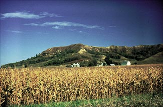
-Pronounced "luss", these steeply sloping bluffs are noted for their composition of silty, buff-colored, windblown soil and their depth of over 200 feet. Quote from Nebraska Geography -Loess is a buff to yellowish-brown loamy dust that is found in North America. Loess is is distributed across an area by the wind. The Great Plains of Nebraska lie to the west of the Till Plains and extend across the state into Wyoming and Colorado. Loess covers the central and south-central Great Plains.
Percy writes: Are you aware that you're citing a website for a fictional world?  I wasn't aware. I did a google image search for 'mountain formation', and google returned that diagram which looked so perfect. I didn't bother to read the contents of that website. I wasn't aware. I did a google image search for 'mountain formation', and google returned that diagram which looked so perfect. I didn't bother to read the contents of that website.
|
||||||||||||||||||||||||||||||||||
|
peaceharris Member (Idle past 5627 days) Posts: 128 Joined: |
I was hoping peace would point out why HE believes mainstream scientists are correct on this interpretation, but not others, like the Coconino. As the wind deposits dust, we would not get a nice horizontal layer, but a wavy landform. If you see a nice horizontal layer, it is caused by water, not wind.
Sahara desert:
The loess hills are wavy:
The Coconino sandstone underneath the Toroweap formation is a nice horizontal strata:
|
||||||||||||||||||||||||||||||||||
|
peaceharris Member (Idle past 5627 days) Posts: 128 Joined: |
PaulK writes: Wouldn't compression and compaction tend to flatten out the sand ? If compression and compaction flattened out the sand, the Coconino footprints would be flattened out too.
Percy writes: Whatever was above, whether it was rugged hills or wavy sand dunes, was eroded flat before the Toroweap was deposited on top when the region again sank beneath sea level. Which is easier, for rugged hills and wavy sand dunes or footprints to be eroded off?
Percy writes: The Coconino does record the sloping sides of sand dunes. This is the crossbedding that was mentioned earlier in this thread.
Sloping sides and crossbedding have been observed in sea coasts. These are not wind deposited.
Cross-bedding in Quaternary beach sands at Saunton Beach
|
||||||||||||||||||||||||||||||||||
|
peaceharris Member (Idle past 5627 days) Posts: 128 Joined: |
Percy writes: I'm not sure why you think this is a point of rebuttal. We already know sandstone layers can be deposited by eolian (wind) or aquatic processes. In my opinion, to debate whether the cross bedding of the Coconino or Navajo sandstone (photo from Roxrkool's earlier post) was deposited by eolian or aquatic processes, we should compare a known cross bedding from a beach and a desert. I have supplied a photo of the cross bedding of Quaternary beach sands at Saunton Beach. Could you supply a photo of a recent wind deposited cross bedding from a desert. Then we'll discuss the differences.
Percy writes: I had asked you if you were wondering why the boundary between the Coconino and the Toroweaps is flat because you thought it should be wavy like the surface of a desert festooned with sand dunes. I still think that's what you thought, and the reason your expectation is incorrect is because there's an unconformity between the layers. Whatever was above the top of the Coconino has been eroded flat.
Yes, that's what I thought. Forces due to erosion do not produce a flat surface. Look at the erosion of the Grand Canyon today. But water sorting produces fairly horizontal strata. This message has been edited by peaceharris, 05-11-2005 11:28 PM
|
||||||||||||||||||||||||||||||||||
|
|
Do Nothing Button
Copyright 2001-2023 by EvC Forum, All Rights Reserved
![]() ™ Version 4.2
™ Version 4.2
Innovative software from Qwixotic © 2024