|

Understanding through Discussion |
|
|
Register | Sign In |
|
QuickSearch
| EvC Forum active members: 64 (9164 total) |
|
| |
| ChatGPT | |
| Total: 916,786 Year: 4,043/9,624 Month: 914/974 Week: 241/286 Day: 2/46 Hour: 0/2 |
| Thread ▼ Details |
|
Thread Info
|
|
|
| Author | Topic: Earth science curriculum tailored to fit wavering fundamentalists | |||||||||||||||||||||||||||||||||||||||
|
edge Member (Idle past 1732 days) 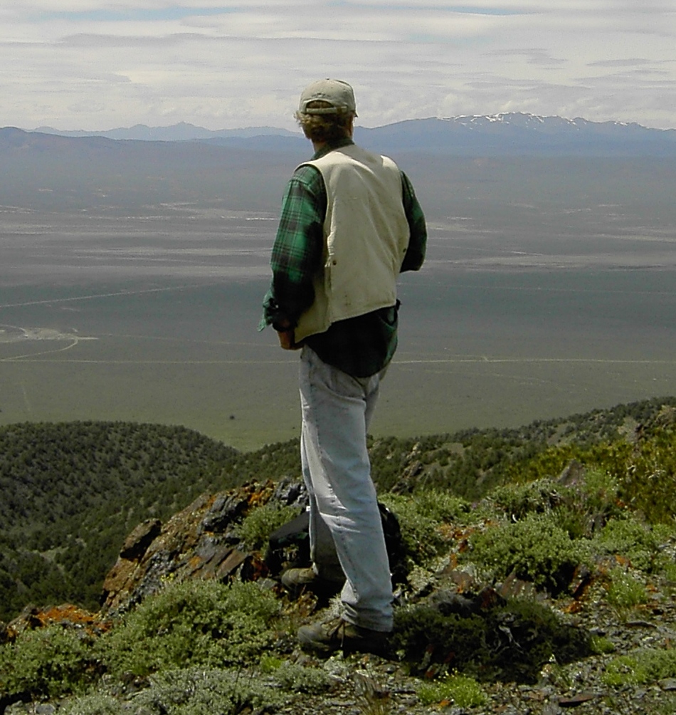 Posts: 4696 From: Colorado, USA Joined: |
In water and in air, it'll be basalt. I don't know if the difference in cooling rates is so different as to make underwater basalt consistently more fine-grained, so that we could use that as a test --- if anyone knows that that's the case, please set me right.
It's hard to get finer-grained that a true 'trap' rock. However, the very presence of water along with rapid cooling will change the texture completely. Most subaqueous volcanics will be fragmental (broken up), and often altered (heat plus water plus dissolved materials). Look up the term 'hyaloclastite' sometime. The exception to this is in the case of some pillow basalts, but again, they have macro-textures that are immediately recognized by virtually all geologists. They are also usually altered to a sodic (remember the salt questions?) type. Again, the reality is complex. For instance, what happens when a magma encounters groundwater? We could go on and on.
|
|||||||||||||||||||||||||||||||||||||||
|
edge Member (Idle past 1732 days) Posts: 4696 From: Colorado, USA Joined: |
Afterthought: this can't even be the case even with underwater volcanism without sea-floor spreading. Otherwise incipient volcanic islands would basically be shaped like hollow pillars, wouldn't they?
Volcanic islands are problematic. Most subaqueous volcanics are pyroclastic; that is, they are broken up and tend to collapse or erode easily. So, what you need is a huge amount of eruptive material to actually form an island that will resist wave action long enough for intrusive and extrusive lava to be deposited and support a long lasting island. As we can see, it does happen. However, if you look at the seafloor topography around the Hawaiian Islands, you will see huge landslide deposits all around the emergent islands.
|
|||||||||||||||||||||||||||||||||||||||
|
edge Member (Idle past 1732 days) Posts: 4696 From: Colorado, USA Joined: |
Well, not so much pillars, but steep cone shape (underwater) vs shallow cone shape (open air).
To amplify on my previous post, the subaqueous lavas encounter water and cool so rapidly that they fragment into tiny grains that are mostly glass and therefor are readily altered in the presence of water. So, they are not only broken up, but they are converted quickly to clay minerals. This means that they are exceedingly weak. That was purely a guess and I accept that there are a TON of things I haven't considered in that 2 second hypothesis. I'm showing a picture here of a subaerial example of clay-altered volcanic rocks in the San Juan Mountains of Colorado. The lobe of material flowed from right to left, into a valley and formed Lake San Cristobal. You might imagine that same type of material partly suspended and thinned by water and and how far it might flow.
I'm also sure that this same phenomenon is what happened in Washignton state a few years ago, killing a number of people. To my mind, a lot of these things are predictable.
|
|||||||||||||||||||||||||||||||||||||||
|
edge Member (Idle past 1732 days) Posts: 4696 From: Colorado, USA Joined: |
f there is one bias they have (and of course they have a lot more than one), anti-radiocarbon is it. It's almost a demon to them.
Heh, heh ... This always seemed odd to me. I think most YECs feel the same way to some degree; but realistically, it's not that big a deal. The other radiometric methods date much older events and are probably much easier to deal with as far as technique. Frankly, it is easier to attack than other methods because of the nature of the 'beast'.
|
|||||||||||||||||||||||||||||||||||||||
|
edge Member (Idle past 1732 days) Posts: 4696 From: Colorado, USA Joined: |
Ah, so the rapid cooling makes the end product structurally weak (my guess). Interesting.
Rapid cooling forming glass fragments, and in the presence of water. We are talking about subaqueous volcanism here. ThanksJB Here is an example of a volcanic island.
quote:Note that the island has lost half its area between 1967 and 2002. Not sure what's happened since then, but at an elevation of 155m, it may have built something of a skeleton and a mass to help resist future wave erosion. Edited by edge, : No reason given.
|
|||||||||||||||||||||||||||||||||||||||
|
edge Member (Idle past 1732 days) Posts: 4696 From: Colorado, USA Joined: |
Don't you also get ash on land and clay in water from the cloud particulate material?
Yes. Ash can fall in air as a cold or hot deposit. If hot enough, it can make a very competent rock. If cold, it will be a fine dust, just as the ash from Mt. St. Helens was deposited over most of the northwest US. That material will essentially disappear and eventually be preserved in places like the Columbia River alluvial fan.
Are not Tuffs formed from ash material compacted and solidified (the footprints in laetoli)?
Again, yes. Tuff is a rock type composed of consolidated volcanic ash. And again, the hotter, the more compacted it can become forming a 'welded tuff'.Volcanic ash - Wikipedia The exact mode of composition, transport and deposition will result in numerous variations of tuffs.
|
|||||||||||||||||||||||||||||||||||||||
|
edge Member (Idle past 1732 days) Posts: 4696 From: Colorado, USA Joined: |
There are also correlations with major volcanic ash clouds causing climate change - the year without a summer (1816) - that also show up as frost rings in trees. The larger the ash cloud the more widespread the effect.
Tambora (Sumbawa Island, Indonesia), April 1815, largest historic volcanic eruption. Up to 100,000 deaths attributed to the climate and tsunami effects of the one, single eruption. Tambora is still considered active. Edited by edge, : No reason given.
|
|||||||||||||||||||||||||||||||||||||||
|
edge Member (Idle past 1732 days) Posts: 4696 From: Colorado, USA Joined: |
I'm seeing a paper by Dr. Robert Lee quoted time and time again in YEC circles and I'm trying to find the actual paper.
Just a quick reference:quote: Lee, Robert E., 1981. Radiocarbon: Ages in error. Anthropological Journal of Canada 19(3): 9-29. Reprinted in Creation Research Society Quarterly 19(2): 117-127 (1982). Any help would be appreciated. I'm always suspect of content when a paper is quoted and quoted but never shown the light of day - when found they never quite seem to say what it is said they say. I went though this with the widely quoted Lammerts paper on bristlecone rings and once found my suspicions were again confirmed in that case. Any help would be appreciated. The only option currently is to by the entire CRSQ back catalog and I'm pretty sure I don't want to pay for that much slime. ThanksJB CD011: Carbon dating. ETA: Heh, heh... Anyone that says this:
quote:...doesn't have a clue. In radiocarbon dating anything over 50ky, depending on the sample characteristics, IS an infinite age. Edited by edge, : No reason given. Edited by edge, : No reason given. Edited by edge, : No reason given.
|
|||||||||||||||||||||||||||||||||||||||
|
edge Member (Idle past 1732 days) Posts: 4696 From: Colorado, USA Joined: |
I tried that earlier, but it says right on that link that single issues can only be bought back to 1984 and what I need is from 1982.
I'm trying to imagine what the world has come to when someone 'needs' an issue of CRSQ... 
|
|||||||||||||||||||||||||||||||||||||||
|
edge Member (Idle past 1732 days) Posts: 4696 From: Colorado, USA Joined: |
quote:What you are seeing is the nature of science and learning about the earth. There were several issues with the origination of the impact theory. As with many debates in the sciences, there was a problem with the mechanism. Some people had a problem with the concept as there was no known source for the iridium layer. As the wiki article shows, the Chicxulub crater was discovered later. The next problem was timing and duration of the extinction event for the dinosaurs. Even to this day, there is still some debate as to how long it took the dinosaurs to go extinct and exactly when it happened. These are not critical to the interpretation of an impact origin for the iridium layer or that it occurred near the K/T boundary, or that the event occurred millions of years ago. And yes, debate in the scientific community can by 'acrimonious'. Bad theories don't last very long in that environment. AFAIK, the layer is global except where it is eroded away. The thing about iridium is that it is a rare element in the earth's crust, and anomalies are pretty well-defined and easy to detect. Even tiny amounts are significant. Edited by edge, : No reason given. Edited by edge, : No reason given.
|
|||||||||||||||||||||||||||||||||||||||
|
edge Member (Idle past 1732 days) Posts: 4696 From: Colorado, USA Joined:
|
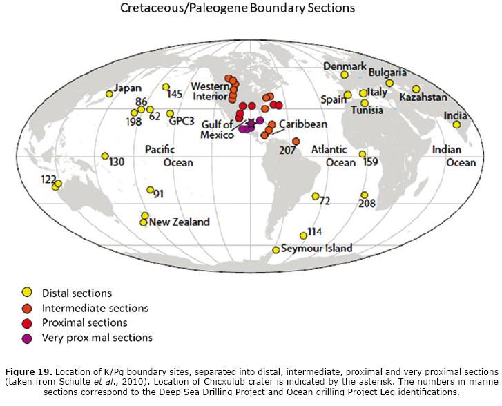
After a little search, I found this map:
In this reference: The Chicxulub multi-ring impact crater, Yucatan carbonate platform, Gulf of Mexico Some of the other figures in the article are important as well, showing, for instance the differences between proximal and distal deposits. Note also that they rely not only on iridium but shocked quartz, magnetics and some other geochemical variability in ferrous metals.
quote: |
|||||||||||||||||||||||||||||||||||||||
|
edge Member (Idle past 1732 days) Posts: 4696 From: Colorado, USA Joined:
|
The thing is, the existence of a worldwide deposition of iridium can be explained in terms of the Flood of Noah too, as evidence of a meteor hit during the Flood, dispersing its iridium along with all the sediments the Flood deposited. I've mentioned it many times here and HERE's one of those posts.
If you presuppose a biblical flood, yes. However, there is no evidence for such a flood event. Besides, you are still using an impact to explain the iridium, not a flood per se. But yes, there could be other things going on at the time. There were probably volcanoes erupting too, but so what?
|
|||||||||||||||||||||||||||||||||||||||
|
edge Member (Idle past 1732 days) Posts: 4696 From: Colorado, USA Joined:
|
The "so what?" is that as long as there is a plausible explanation for a given phenomenon's being caused by the Flood, you can't use it as an argument against YEC belief in the Flood.
Ummm, ... we aren't doing that. Impacts can happen whether there was a flood or not. We were discussing the global occurrence of an iridium layer supporting the interpretation of a global event caused by an extraterrestrial origin. Your flood has nothing to do with this discussion. Edited by edge, : No reason given.
|
|||||||||||||||||||||||||||||||||||||||
|
edge Member (Idle past 1732 days) Posts: 4696 From: Colorado, USA Joined: |
I think it does for ThinAir. His whole point is to find arguments against YEC.
A very specific question was asked. I was attempting to answer. There was nothing in the question regarding the validity or disproof of a flood. When the flood comes up, your statement will be relevant... maybe. Or maybe you could complain that the iridium layer does not disprove the existence Cambrian mammals, also.
|
|||||||||||||||||||||||||||||||||||||||
|
edge Member (Idle past 1732 days) Posts: 4696 From: Colorado, USA Joined:
|
If the Flood explains it all, there is no such thing as "Cambrian" animals for iridium to prove or disprove. They're all antediluvian creatures from bottom to top of the geo column.
Are you saying that the flood explains the iridium layer? If so, then you need to explain your explanation.
|
|||||||||||||||||||||||||||||||||||||||
|
|
Do Nothing Button
Copyright 2001-2023 by EvC Forum, All Rights Reserved
![]() ™ Version 4.2
™ Version 4.2
Innovative software from Qwixotic © 2024


 (1)
(1)