|

Understanding through Discussion |
|
|
Register | Sign In |
|
QuickSearch
| EvC Forum active members: 64 (9164 total) |
|
| |
| ChatGPT | |
| Total: 916,784 Year: 4,041/9,624 Month: 912/974 Week: 239/286 Day: 46/109 Hour: 0/3 |
| Thread ▼ Details |
|
Thread Info
|
|
|
| Author | Topic: Growing the Geologic Column | ||||||||||||||||||||||||||||||||||||||||||||
|
edge Member (Idle past 1732 days)  Posts: 4696 From: Colorado, USA Joined: |
So you send samples for radiometric testing?
I have done it several times in my career to answer specific questions. I have also done research into existing radiometric data to help straighten out a complex rock sequence. Edited by edge, : No reason given.
|
||||||||||||||||||||||||||||||||||||||||||||
|
JonF Member (Idle past 194 days) Posts: 6174 Joined: |
Ask Percy, I 'my assuming he is correct. I will look but I am on a tablet now and such searching is cumbersome.
|
||||||||||||||||||||||||||||||||||||||||||||
Faith  Suspended Member (Idle past 1470 days)  Posts: 35298 From: Nevada, USA Joined: |
I dunno edge, you really think soil piling on top of a folded block of layers is going to end up as an angular unconformity? The upper section at Siccar Point looks like a separate flat layer altogether, perched straight across the tilted rocks, but wouldn't the soil in the present example penetrate into the crevices instead of forming a layer with flat surfaces? Same I'd guess with the valley and ridge situation. Eroded I guess but flat enough so that a layer as flat as those in say the Grand Canyon would form over it? As flat as that jutting Tapeats ledge we can see in some of the photos of the Great Unconformity? (Actually I don't see how that very flat Tapeats could have laid itself down on the supposedly eroded surface that would have been left in the accepted scenario either: the scenario that has the unconformity being the base of a mountain range that then eroded all the way down, supposedly flat enough for the other layers to deposit beginning with the Tapeats, but how flat could that be? )
Also, maybe I got this wrong but I thought I just read you saying somewhere in these recent posts that there is no erosion between upper and lower sections of an angular unconformity? If I find it and got it wrong I'll come back and correct this. But shouldn't there be erosion if the lower part is eroded down before the upper is deposited? Edited by Faith, : No reason given. Edited by Faith, : No reason given. Edited by Faith, : spelling crevice error
|
||||||||||||||||||||||||||||||||||||||||||||
|
Faith Suspended Member (Idle past 1470 days) Posts: 35298 From: Nevada, USA Joined: |
I just supposed that in the case you described of having two intrusive rocks whose age you didn't know that's what you would have to do. Is there another way to determine it?
|
||||||||||||||||||||||||||||||||||||||||||||
|
Coyote Member (Idle past 2132 days)  Posts: 6117 Joined: |
So you send samples for radiometric testing?
I have done it several times in my career to answer specific questions. I have also done research into existing radiometric data to help straighten out a complex rock sequence. Your's probably is also.Religious belief does not constitute scientific evidence, nor does it convey scientific knowledge. Belief gets in the way of learning--Robert A. Heinlein How can I possibly put a new idea into your heads, if I do not first remove your delusions?--Robert A. Heinlein It's not what we don't know that hurts, it's what we know that ain't so--Will Rogers If I am entitled to something, someone else is obliged to pay--Jerry Pournelle If a religion's teachings are true, then it should have nothing to fear from science...--dwise1 "Multiculturalism" does not include the American culture. That is what it is against.
|
||||||||||||||||||||||||||||||||||||||||||||
|
JonF Member (Idle past 194 days) Posts: 6174 Joined:
|
From Fission Tracks in Zircons: Evidence for Abundant Nuclear Decay (I've made the X's red:
Caption: Correlation of the Cambrian Tonto Group showing facies changes in the western Grand Canyon (after McKee and Resser [1945]; Elston [1989]). The stratigraphic position of the thin Muav and Tapeats tuff units are indicated by xxxxxx. The references are to books that are not readily available on-line.
|
||||||||||||||||||||||||||||||||||||||||||||
|
Faith Suspended Member (Idle past 1470 days) Posts: 35298 From: Nevada, USA Joined: |
I don't think you got what I was trying to say. Which was that layers deposited above and after the tectonic distortion should be horizontal on their surface, since sediments deposit horizontally, but they aren't, they conform to the surface shape of the lower rocks.
Yes, it shows that the deformation is ongoing and that it started a long time ago. I would expect this in a place such as the Mississippi Delta and the Gulf of Mexico as sediments compact and dewater at depth. Which doesn't seem to have anything whatever to do with what I said. If sediments deposit horizontally then their upper surface should not conform to the shape of the lower rocks.
I think you are missing the point that deformation is decreasing upward. I must be missing it because I don't get why you are emphasizing it.
If they were deposited later and then deformed later as well they also wouldn't conform to the shape of the lower rocks, they would have their own pattern of deformation independent of them.
I'm not sure why you would say this. They do have their own pattern which is 'less deformed' than the lower rocks. The fact that the deformation is occurring in the same tectonic setting means that they will have some similarities, but the intensity is less. What you are talking about is something entirely different from what I am talking about and I don't know what you are getting at. Again, if sediments deposit horizontally then any that deposited after the lower layers were deformed should have horizontal surfaces, and if those too eventually get deformed, at least their upper surface should not follow the shape of the lower rocks. Am I not getting this across? Wherever there is parallel structure that means that whole block was already laid down horizontally as a block and then deformed as a block. So where this occurs it contradicts the interpretation that the deformation occurred before the next layer was laid down.
[qs] But the Albian for one, except at the far left, keeps parallel to the shape of the lower rocks all the way to the far right. Why doesn't it have a flat horizontal surface, or at least a surface deformed differently from the rocks below it?
The entire pile of sediment is settling, and there is no reason why a surface should remain perfectly flat. But what I'm saying is that when it does get deformed it should not conform to the shapes of the rocks below it if it was deposited after they were deformed. Presumably it deposited horizontally which does not follow the shape of the rocks below, but then it also gets defomed and still wouldn't follow the shape of the rocks below. Yet most of the rocks are parallel in the diagram.
In fact, if what you said were true, the salt would never flow. And that flow is just another factor in the irregularities of the formation contacts. I'm not following this. The layers ARE parallel in most of the diagram, which I guess is what allows the salt to flow? All I'm saying is that they shouldn't be parallel wherever the upper ones were deposited after the lower were deformed, as some here are claiming happened. Since they are parallel I conclude that they were already in place and not deposited after the lower ones were deformed. I was up all night and I'm falling asleep at the keyboard. Finish this later.
|
||||||||||||||||||||||||||||||||||||||||||||
|
Percy Member  Posts: 22492 From: New Hampshire Joined: Member Rating: 4.9
|
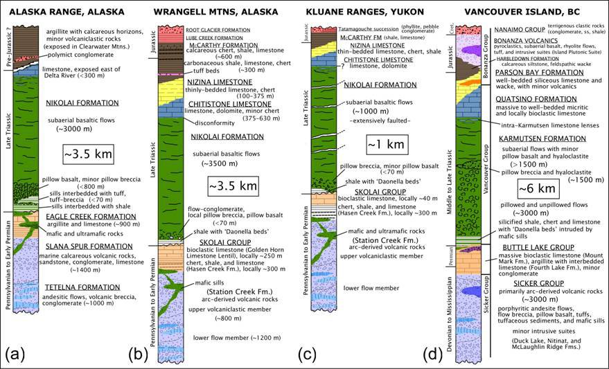
Faith writes: The image I presented from Alaska has the time periods on the chart.
I looked and looked, guess I nevertheless managed to miss it. I think I can help you find them. Here's the image again:
Expand the image to full size. Tilt head sideways to the left. The sideways text on the left of each column should now be easily readable. It provides the time periods like "Late Triassic" and so forth.
Well, if it occurred at the time of the breakup of Pangaea that's right when I'd expect volcanism to occur too. After the Flood though. Not in any supposed Triassic time period. To clarify what you mean by "it", you're saying that the layers in that image were not deposited in the Triassic. One would have expected a little evidence to accompany so dramatic a claim. The evidence from radiometric dating and fossils says those layers were from the Triassic. The Triassic must predate your flood because it predates layers you claim were deposited by the flood, such as the Claron Formation at Bryan Head. Those Alaskan Triassic layers are underlain by Permian layers that are roughly the same age as the Coconino at the Grand Canyon. Any way you look at it your viewpoint runs into contradictions. If the layers in that image are post flood then obviously the building of the geologic column did not end at the flood, falsifying one of your claims. And if the layers are pre-flood or concurrent with the flood then layers of volcanic tuff are interspersed with sedimentary layers, falsifying a different one of your claims. If you're not wrong one way you're wrong another. --Percy
|
||||||||||||||||||||||||||||||||||||||||||||
|
Percy Member Posts: 22492 From: New Hampshire Joined: Member Rating: 4.9
|
Faith writes: She has started several times that her reading of the Bible is infallible.
Never said any such thing. JonF pointed out where you said exactly that in another thread, and in this very thread you stated that the Bible is the final word, that you and others like you have the correct interpretation, and that though there are differences among you that you all concur on the important points, and that religions whose interpretations differ on important points (like the Roman Catholic church) are false churches. Your rule seems to be, "Anyone who disagrees with me is wrong." The rule everyone else is following is, "If you can't support your arguments with evidence, please go find some evidence before continuing the discussion." By the way, the evidence has to be connected to the arguments. You *have* cited a great deal of evidence, but almost none of it connects to your arguments. It's all non sequiturs as bad as, "I'll be faster if I carry Usain Bolt sports cards in my back pocket." You always emphatically insist that everything you say is correct, but only until the absurdity of something you've said finally dawns on you, at which point you switch to delivering a lecture on how we willfully misinterpret or exaggerate or overliteralize everything you say. Lecture time again, I presume? --Percy
|
||||||||||||||||||||||||||||||||||||||||||||
|
Percy Member Posts: 22492 From: New Hampshire Joined: Member Rating: 4.9
|
Faith writes: No, I am not, and cannot be, certain about any of the scientific questions we are talking about, and I also said that being fallen I also need help to read the Bible. The only dogma I've acknowledged is the Bible itself. Did I hear right? Did you just say that your interpretation of the Bible is not necessarily correct? If so, then how do you know you're fallen? Isn't that just *your* interpretation of the Bible? Is it possible you're wrong about being fallen? And how do you know there was a global flood 4300 years ago? Isn't that just *your* interpretation of the Bible? And how do you know the global flood followed all the laws of the natural universe and had no divine intervention? Isn't that just *your* interpretation of the Bible? And how do you know the world was tectonically inactive prior to 4300 years ago? Isn't that just *your* interpretation of the Bible? Etc. I have to say again that you only have faith in these things, no evidence. We can see you struggling mightily to twist some of the evidence into something supportive of the Flood while ignoring the rest, but you can't make it through even the shortest post without claiming that what really happened is something either in contradiction to all evidence or physically impossible and in violation of the known laws of physics. --Percy
|
||||||||||||||||||||||||||||||||||||||||||||
|
edge Member (Idle past 1732 days) Posts: 4696 From: Colorado, USA Joined:
|
I dunno edge, you really think soil piling on top of a folded block of layers is going to end up as an angular unconformity?
Do you think that the soil is permanent? Do you know that many unconformities have paleosoils?
The upper section at Siccar Point looks like a separate flat layer altogether, perched straight across the tilted rocks, but wouldn't the soil in the present example penetrate into the crevices instead of forming a layer with flat surfaces?
What do you think will happen to that soil when the next marine transgression occurs?
Same I'd guess with the valley and ridge situation. Eroded I guess but flat enough so that a layer as flat as those in say the Grand Canyon would form over it?
As I said, this is an ongoing process. I knew this would trip you up.
As flat as that jutting Tapeats ledge we can see in some of the photos of the Great Unconformity?
You mean in the transgressing sea that had islands of Shinumo Quartzite that penetrated entirely up through the Tapeats?
(Actually I don't see how that very flat Tapeats could have laid itself down on the supposedly eroded surface that would have been left in the accepted scenario either: the scenario that has the unconformity being the base of a mountain range that then eroded all the way down, supposedly flat enough for the other layers to deposit beginning with the Tapeats, but how flat could that be? )
Yep, just more evidence for old ages.
Also, maybe I got this wrong but I thought I just read you saying somewhere in these recent posts that there is no erosion between upper and lower sections of an angular unconformity?
No. That's the whole point. It's an erosional surface.
If I find it and got it wrong I'll come back and correct this. But shouldn't there be erosion if the lower part is eroded down before the upper is deposited?
How do you think the crests of the folds were planed off?
|
||||||||||||||||||||||||||||||||||||||||||||
|
edge Member (Idle past 1732 days) Posts: 4696 From: Colorado, USA Joined: |
I just supposed that in the case you described of having two intrusive rocks whose age you didn't know that's what you would have to do. Is there another way to determine it?
Maybe. You got plenty of money to waste? Is there another way for you to move the goalposts?
|
||||||||||||||||||||||||||||||||||||||||||||
|
edge Member (Idle past 1732 days) Posts: 4696 From: Colorado, USA Joined: |
Nice find! Never seen this before, but I'm not really surprised.
|
||||||||||||||||||||||||||||||||||||||||||||
|
edge Member (Idle past 1732 days) Posts: 4696 From: Colorado, USA Joined:
|
I must be missing it because I don't get why you are emphasizing it.
Because, it indicates that deformation started early and continued so that the later layers only received the last part of the deformation. This is not rocket science...
What you are talking about is something entirely different from what I am talking about and I don't know what you are getting at. Again, if sediments deposit horizontally then any that deposited after the lower layers were deformed should have horizontal surfaces, and if those too eventually get deformed, at least their upper surface should not follow the shape of the lower rocks. Am I not getting this across?
Well, maybe to you, it is rocket science. Yes, all units are deformed. Why are the deeper units more deformed and why do faults not reach the surface? Think about it.
Wherever there is parallel structure that means that whole block was already laid down horizontally as a block and then deformed as a block. So where this occurs it contradicts the interpretation that the deformation occurred before the next layer was laid down. But the Albian for one, except at the far left, keeps parallel to the shape of the lower rocks all the way to the far right. Why doesn't it have a flat horizontal surface, or at least a surface deformed differently from the rocks below it? But what I'm saying is that when it does get deformed it should not conform to the shapes of the rocks below it if it was deposited after they were deformed.
Why not?
Presumably it deposited horizontally which does not follow the shape of the rocks below, but then it also gets defomed and still wouldn't follow the shape of the rocks below. Yet most of the rocks are parallel in the diagram.
Not really. what do you see in the Paleozoic rocks? There are very few truly parallel contacts in this diagram and they are frequently broken by faults.
|
||||||||||||||||||||||||||||||||||||||||||||
|
Percy Member Posts: 22492 From: New Hampshire Joined: Member Rating: 4.9
|
Faith writes: You have stated that your idea is that all the sediment was deposited before any tectonic activity occurred. Yes, that's the case in the GC-GS area for sure so I'm expecting to find it elsewhere as well. The GC/GS region is not the poster child for all sediments everywhere. It is not the one true geologic history of what happened everywhere on the planet. The only reason there is so much data and so many images of this region is because it is so easy to study because the layers are exposed and easily accessible, both at the Grand Canyon and at numerous other locations in the area. This abundance of data about the GC/GS region has somehow fooled you into thinking that whatever happened there is, in broad outline, what must have happened everywhere else. But why on Earth would you think this? Do you think the weather in Seattle is typical of the world and that it rains everywhere all the time? Of course not. Do you think the volcanoes on Hawaii are typical and that there are volcanic eruptions all over the world? Of course not. Do you think Antarctica is typical and that it snows everywhere all the time? Of course not. Do you think the Sahara is typical and that it is hot and dry everywhere all the time? Of course not. Do you think Los Angeles is typical that there are earthquakes everywhere all the time? Of course not. Then why do you think the GC/GS region is typical? It isn't close to any tectonic boundaries, so tectonic action would be expected to be less there, and that's we observe, but there is not a total absence of tectonic activity. You won't admit there's any pre-Flood tectonic activity anywhere on the planet, but not for reasons that make sense to anyone but you. I hope you've addressed this question in the portion of the thread I haven't read yet, but if not maybe you'll address it now? If you can't justify with evidence your belief that the GC/GS region is somehow typical of the rest of the world, then it really is something you should drop until you find such evidence. --Percy
|
||||||||||||||||||||||||||||||||||||||||||||
|
|
Do Nothing Button
Copyright 2001-2023 by EvC Forum, All Rights Reserved
![]() ™ Version 4.2
™ Version 4.2
Innovative software from Qwixotic © 2024