|

Understanding through Discussion |
|
|
Register | Sign In |
|
QuickSearch
| EvC Forum active members: 64 (9164 total) |
|
| |
| ChatGPT | |
| Total: 916,768 Year: 4,025/9,624 Month: 896/974 Week: 223/286 Day: 30/109 Hour: 3/3 |
| Thread ▼ Details |
|
Suspended Member (Idle past 5941 days)  Posts: 1024 From: Pacific Northwest Joined: |
|
Thread Info
|
|
|
| Author | Topic: Young earth explanations for Angular Unconformities | |||||||||||||||||||||||||||||||||||||||||||
|
edge Member (Idle past 1732 days)  Posts: 4696 From: Colorado, USA Joined: |
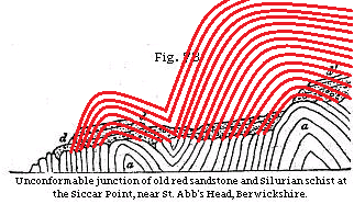
Faith may not have followed your argument about the degree of mechanical action, and I may not either. You seem to be drawing a contrast between relatively fast erosion (high mechanical action) that leaves a clean and new looking surface, versus weathering which results from long exposure with small scale erosion (low mechanical action) that results in the aged appearance we're familiar with in some rocks such as at Siccar Point. If I have that right then I get it, but I'm not sure Faith does.
Yes, that is the point of my argument. At Siccar, material was being constantly removed as it was weathered. In other locations, the rock would be weathered deeply, in place, and not removed by mechanical erosion prior to deposition of the upper sequence above the unconformity. I think we have seen the effects of weathering in many of the Grand Canyon images as well. One of the products of weathering would be paleosoils which we do see in the geological record, though not at Siccar or at the Grand Canyon.
|
|||||||||||||||||||||||||||||||||||||||||||
|
edge Member (Idle past 1732 days) Posts: 4696 From: Colorado, USA Joined: |
Once tilted vertical, layers E through H have a limited extent, bounded by layers A through D at the top and by other rock at the bottom. In your scenario the miles of extent of layers have become truncated into a very short distance. Where did all the missing material go?
One argument would be that the space is taken up by folding of the underlying sequence. It could, theoretically, be doubled, tripled or even more in thickness by folding. In reality, however, this would be effectively impossible unless the lower block had absolutely no strength and could flow wherever forced. But then that would mean that all bedding would be fluidized and the section would be unrecognizable as a sedimentary rock. What you are talking about is what we used to call a 'room' problem. In deforming the rock, you either create space that has to be filled with something, or you force so much material into a small space that it is forced to escape. In either case, you have caused certain deformation features that would be easily recognizable. Folding produces crests and troughs. The crests basically move upward and the troughs downward to accommodate shortening in a lateral direction. This would necessarily involve the upper layers. They would have to be moved and/or broken.
|
|||||||||||||||||||||||||||||||||||||||||||
|
edge Member (Idle past 1732 days) Posts: 4696 From: Colorado, USA Joined: |
Why do you think tectonic forces generated from within the Earth require some sort of counterweight?
I think that Faith is trying to describe a confining pressure. Confining pressures are mostly due to overburden weight in earth processes. My question for Faith on this would be, "which rock section would have more confining pressure, the upper block or the lower?" So which one should deform first, everything else being equal? Here is an example:
Note that the upper layers are folded, whereas the lower layers resisted folding. That is because the upper layers only had to lift themselves and the air above them. The lower layers tend to be confined. Lower layers also tend to be stronger since they have been lithified for a longer time. However, in an overthrust situation, older rocks will override younger. Notice also that the detachment surface cuts across beds in the lower section along a smooth surface. ETA: By the way, this is a true detachment fault where the upper block has slipped across the lower for an uncertain distance. Edited by edge, : No reason given. Edited by edge, : No reason given. Edited by edge, : No reason given.
|
|||||||||||||||||||||||||||||||||||||||||||
|
edge Member (Idle past 1732 days) Posts: 4696 From: Colorado, USA Joined:
|
I think we should appreciate all the help we can get from Edge. Hopefully he can confirm what I've told you about angular unconformities, that basic geology believes they form when the higher portions of the tilted layers are eroded away.
I don't think it's too much of a stretch to say that the layers you reconstituted in the modified diagram were continuous and were present prior to erosion. The full thickness would be unknown to us without looking at regional geology to see what other formations might have been on top of the lower sequence of rocks. It could be quite substantial. This seems to be another case where YECs deny the effects of erosion which always puzzled me since we actually live on an unconformity...
|
|||||||||||||||||||||||||||||||||||||||||||
|
edge Member (Idle past 1732 days) Posts: 4696 From: Colorado, USA Joined: |
Nothing new about it. It's what Hutton surmised when he first saw Siccar Point. Regarding my drawing where I completed the layers of the angular unconformity that had been eroded away:
Assuming continuity of the layers, which is a necessary assumption, a whole lot of the lower sequence has been somehow removed. I'm wondering where, in Faith's scenario, that material went and how it got there.
|
|||||||||||||||||||||||||||||||||||||||||||
|
edge Member (Idle past 1732 days) Posts: 4696 From: Colorado, USA Joined: |
I'm not sure what is meant by "lower sequence", so Faith not know what is meant, either.
Well, there is one sequence of rocks above the unconformity and another below. I called them 'upper' and 'lower'. The could be called something else if that makes things clearer. I'm open to suggestions. ETA: in this case, a sequence would be a continuous layering of rocks through time. Edited by edge, : No reason given. Edited by edge, : No reason given.
|
|||||||||||||||||||||||||||||||||||||||||||
|
edge Member (Idle past 1732 days) Posts: 4696 From: Colorado, USA Joined: |
I still want to know how you explain the FACT that the rocks ARE folded despite the absence of this sort of evidence of folding you are talking about.
All I was saying is that in the images we have been looking at, you cannot see a fold axis. I'm certain that they exists and are visible on a larger scale. However, as we have seen, this does not help you in the least.
I also don't think you've answered the question about how rocks get folded or tilted without tectonic pressure.
I never said otherwise. I said that we do not see the tectonic structures that would be expected for a shear zone between the two packages of rocks. I was very careful in my wording on this.
|
|||||||||||||||||||||||||||||||||||||||||||
|
edge Member (Idle past 1732 days) Posts: 4696 From: Colorado, USA Joined: |
The uppermost portion of the tilted strata. Not a separate layering of strata.
All I'm saying is that we do not know what was above the actual, original sedimentary rocks that we see at Siccar, based on the images that we have seen. I also said that a regional investigation would tell us if there were such rocks.
Duh.
Your word, not mine.
|
|||||||||||||||||||||||||||||||||||||||||||
|
edge Member (Idle past 1732 days) Posts: 4696 From: Colorado, USA Joined: |
Calling them the lower sequence is fine, but in that case I don't know what you meant by "a whole lot of the lower sequence has been somehow removed." If the lower sequence is the portion below the unconformity, none of it has been removed. I still have a feeling there may still be a terminology issue in play, either that or I'm missing something.
Certainly. What I'm saying is that the portions of the fold that were above the current location of the unconformity (the red lines) are gone. They had to go someplace, no? Edited by edge, : No reason given.
|
|||||||||||||||||||||||||||||||||||||||||||
|
edge Member (Idle past 1732 days) Posts: 4696 From: Colorado, USA Joined:
|
I haven't "seen" any of your claims so far.
Of course not. I never expected you to.
It's all a big cheat.
Well, if you don't know the rules of the game, everything seems like a cheat.
As always, there comes a point when discussions with you devolve into you making unverifiable claims in order to win the argument. This gets old.
I'm sorry, but this is partly a technical discussion. I am trying to make it simpler, but have apparently failed. The story of unconformities is a huge and complex subject. But important and fascinating as well.
|
|||||||||||||||||||||||||||||||||||||||||||
|
edge Member (Idle past 1732 days) Posts: 4696 From: Colorado, USA Joined: |
No, Faith, I never said anything like that, and until just now you never said that was your understanding of what I said. You might at least try keeping to a consistent story.
I understood you completely and it made perfect sense. There may well be a large sequence of rocks stratigraphically above the ones we see at Siccar, but still older than the Red Sand. They would have been folded along with the lower sequence but are not eroded completely away. The thing is that we do not have the information here. It probably exists, but I'm not sure that it's worth the time to track down.
Summarizing the big problems with your fantasy scenario, cubic miles of strata cannot disappear without a trace (meaning no remains of rubble or signs of shearing), disturbances to buried strata cannot fail to disturb overlying strata, rocks weather to form the appearance of age according to their composition and length of exposure and not how long ago they formed, and sedimentary rocks do not form by drying.
Funny how a simple question can have so many implications ...
|
|||||||||||||||||||||||||||||||||||||||||||
|
edge Member (Idle past 1732 days) Posts: 4696 From: Colorado, USA Joined: |
It had to go somewhere on either theory, and as I said before if it was all eroded away at the surface there would be some evidence of it in the folds of the rocks, but apparently there isn't.
Well, that fact that there are eroded cobbles of the lower rocks at the base of the Red Sand suggests that it was simply removed by mechanical erosion.
On my scenario I suggest it was pushed out at the "front" of the formation, ...
Then one should be able to find it.
... the front being the part exposed to view in all the pictures.
There you just lost me. There is nothing showing there.
There's usually lots of rubble around formations. Or it got pushed along the horizontal path of the unconformity. Somewhere there is an unidentified pile of rubble that is where it went.
Well, some of it is found as beds in higher layers in the Red Sand. That suggests erosion as the culprit. Edited by edge, : No reason given.
|
|||||||||||||||||||||||||||||||||||||||||||
|
edge Member (Idle past 1732 days) Posts: 4696 From: Colorado, USA Joined:
|
I mentioned the apparently equal weathering above and below the unconformity as evidence that the standard interpretation is false: i.e., that the lower section was laid down and then tilted, and that a long time later the upper section was deposited on top of it. Since millions of years are usually ascribed to such blocks of strata, there should be a difference in weathering apparent between the two blocks, but they show no such difference.
No. I said that the weathered rock was removed by mechanical erosion and that the lower rocks were covered shortly after erosion.
To my argument that the lower section was tectonically tilted/folded, edge said there is no evidence of tectonic structures. When I asked him to explain how the tilting occurred without tectonic pressure he eventually said of course there was tectonic pressure, he wasn’t denying that. So why then make an issue of there being no tectonic structures? I think he answered this somewhere but I don’t recall the answer and I find it hard to follow this sort of verbal game-playing anyway.
That is because I was referring to a fault plane not folding. In fact, in the images of the unconformity there is no tectonic structure. There are just tilted beds. Until you look at a larger area do you see actual folds.
When I elaborated that the lower section wasn’t just tilted but folded, and put up the drawing by Lyell demonstrating that, he said there is none of the usual evidence of folding and posted a picture which I guess shows stretched rock. But we KNOW that the rock was folded so what does this supposed absence of evidence demonstrate? Just more game-playing obfuscation it seems to me.
Again, I was referring to the images only. In fact, if you had no other information, you could not tell that there was a fold or anything about that fold. There are other ways to tilt bedding planes.
There are also none of the usual signs of shearing, he says, to counter my idea that the unconformity must have been formed by shearing between the upper and lower sections. I don’t really care if literal shearing is how it happened, the point is that the two sections moved against each other. The result could be lumpy. He answered that there should be evidence in any case. I don’t find this very convincing. A lack of evidence isn’t normally considered to be acceptable evidence of the absence of a phenomenon.
I have seen probably thousands of fault surfaces. Unless they have been somehow modified by deformation and heat, they always show signs of motion. The only way to get relative motion without any shear is to move the two sides directly apart. And I've seen that too. And the amount of movement involved, AFAICT about Faith's scenario, is ample. It should absolutely show signs of shear.
At some point edge put up a picture of an unconformity with a granite base and sandstone layers topping it. He kept referring to the granite as forming boulders. I missed his point I’m afraid, I still don’t know what he intended to be arguing with that picture. But it was interesting for the fact that a depression in the granite was not filled by sand from the sandstone layers above, which to my mind shows that the depression occurred after the sandstone was in place.
An artifact of an oblique image. There were pretty obvious fractures in the granite showing spheroidal weathering that would only occur during long periods of weathering. The purpose of this image was to show Faith a location where the underlying rocks actually were more weathered than the rocks overlying an unconformity. This is due to the fact that the granite was not being mechanically removed as it was weathered. I can see that my attempt to help the understanding of unconformities failed.
Then he posted a picture of folded rock above some flat layers that was intended to answer my idea that the folding of the rock at Siccar Point was made possible by a great weight of strata that would have been above the folded rock. He claimed there had been no strata above the folded rock in the picture, but how does he know that? If the rock is very old then it is very likely that just like Siccar Point there would have been a deep stack above it at the time of folding.
Actually, I never said such a thing. The point was that in real detachment situations, the upper rocks are more likely to fold than the lower. It was also to show how a sharp, smooth shear surface forms between the two blocks in a shear zone.
Through all these different issues there was Percy’s constant refrain about how my argument fails because there would have been an enormous amount of material that just disappeared. Well, it disappeared from the pictures we have of such formations, but that doesn’t mean it didn’t get pushed somewhere that just isn’t recognized, outside the formation as we normally view it, even perhaps the cause of the formation’s being exposed on a certain surface; or deep within it somewhere we also don’t get to see.
And then you are challenged to find this deposit. But you also left out the point that folding of the underlying rocks would create room problems for the overlying material that would be deformed during folding. You can't just fold rocks without creating zones of dilation and compression that would affect the overlying units.
This thread has bounced from one issue to another without any of them being addressed to any useful extent, in some cases not addressed at all.
Perhaps you could read our posts more carefully and leave your presuppositions behind for just a moment. I think that most people here have good understanding of the points being made.
|
|||||||||||||||||||||||||||||||||||||||||||
|
edge Member (Idle past 1732 days) Posts: 4696 From: Colorado, USA Joined:
|
You have described this perfectly.
Exactly. I feel kind of like Alice in Wonderland when I read Faith's posts. I have no idea where to even start discussing her points. So often, I simply have to guess what is going on. It reminds me of a sci-fi movie where the time traveler ends up in a mental ward because no one can understand what she is talking about. A complete break with reality. I liken her scenario about folding the lower rocks but leaving the upper rocks intact, to a horizontal trash compactor. The difference is that compactors use high-strength steel to confine the compressed material, not sandstone. And the container still shows signs of shearing ...
|
|||||||||||||||||||||||||||||||||||||||||||
|
edge Member (Idle past 1732 days) Posts: 4696 From: Colorado, USA Joined: |
I didn't understand this, but let me venture a guess: do you mean that the lower rocks were eroded a long, long time ago, then shortly after that erosion the upper layers were deposited upon them, then the upper layers were buried, then they were exposed along with the lower layers that now make up a small cliff face, ...
That is the story. The critical part, however, is that the granite was not mechanically eroded fast enough to remove the weathered material. I think that part of the problem here is the difference between weathering and erosion. This is a very important distinction.
... then weathering removed some upper layer rock by mechanical erosion.
Not necessarily part of the story. In fact, I might say that the erosion that exposes the cliff face may be artificial, i.e. a road cut or something to that effect.
Not sure which images are meant.
In this case, I'm referring to the original images of Siccar Point, showing the unconformity.
My guess is that you're trying to explain that the weathering effects that caused the way the overlying sandstone and the underlying granite appear today was not what caused the embedded granite boulders to become mechanically weathered into spheroidal shapes.
I am only referring to the weathered granite. The sandstone, being composed of quartz hardly weathers at all. The boulders are formed by spheroidal weathering of granite along fractures. The 'boulders' are not yet actual boulders. But they will be some ages hence. They are also not yet mechanically eroded, though they are chemically weathered. Does this help? I am so accustomed to reading the rock record that it's all second nature to me.
About the depression Faith refers to that's about 1/3 of the way from the left side of the image and at the boundary between the sandstone and granite? That looks like it's really there to me. It looks like one of the granite boulders detached from the granite face and fell to the ground.
Almost certainly. There is a shadow below the overhanging sandstone layer. Faith thinks that this is a depression in the granite, present before the sandstone was deposited. And yes, Faith seems to think that this was an original depression in the granite. In that case, there are a lot of original depression visible in this image.
|
|||||||||||||||||||||||||||||||||||||||||||
|
|
Do Nothing Button
Copyright 2001-2023 by EvC Forum, All Rights Reserved
![]() ™ Version 4.2
™ Version 4.2
Innovative software from Qwixotic © 2024


 (1)
(1)