
|

Understanding through Discussion |
|
|
Register | Sign In |
|
QuickSearch
Summations Only | Thread ▼ Details |
|
Member  Posts: 3945 From: Duluth, Minnesota, U.S. (West end of Lake Superior) Joined: Member Rating: 10.0 |
|
Thread Info
|
|
|
| Author | Topic: Continuation of Flood Discussion | |||||||||||||||||||||||||||||||||||||||||||
|
Minnemooseus Member Posts: 3945 From: Duluth, Minnesota, U.S. (West end of Lake Superior) Joined: Member Rating: 10.0 |
This attempt at a new topic is a result of message 347 at the "Why is evolution so controversial?" topic. That topic has a pretty good discussion going. Unfortunately that discussion has wandered very far from the original topic theme.
That message 347 writes: Tanypteryx writes: Minnemooseus writes: Pretty damn bogus reply. I can't see AT ALL how the deep ocean basin deposition model really has anything to do with any with the sediment deposition of the Grand Canyon area rocks. At best, MAYBE the bottom-most pre-Cambrian rocks that are now high grade metamorphics MIGHT have some sort of deep ocean origins. MAYBE. Maybe you are right. I assumed that the limestones and shales were from an ocean deposition and I thought the sandstones were from deposition closer to continental shelf. Obviously, the crossbedded sanddune deposits were deposited when it was dry land. Can you tell me what the depositional environment was?
Faith writes: The accumulations of sediment you can point to here and there are paltry little collections by comparison. It seems to me that deposition happening in the present in the Pacific cannot be described as here and there or paltry on a timescale of millions of years. thanks. Now, some of the sediments of the Grand Canyon and are are of non-marine (above sea level) origin, but here I'm going to try to focus on depositions of on to/off of the continents sea transgressions/regressions. A (the?) central focus of said are sedimentary facies and Walther's Law. I've tried in the past to find good Walther's Law references and graphics, and have never been real happy with what I've found. Go ahead and Google "Walther's Law" and see what you can find. One (sort of) good starting point I did find is facies. Please also look at this. Basically, Walther's Law is that, in sea transgressions/regressions, the coarsest clastic sediments (sand to become sandstone) are deposited nearest to the shoreline. As you go further from shore (and deeper) the clastics get progressively finer to silts (siltstone) and then clays (shale). As you get far enough from shore the clastic sediments become less and less until what sedimentation you have left happening is carbonate (limestone). For a sea transgression, this results in a vertical sequence of upward fining - Sand at the bottom, carbonate at the top. For the sea regression, the order is opposite - Carbonate at the bottom, sand at the top. The transgressive sequence:
ADDED BY EDIT - The above diagram is deceiving in that the silt, clay, and carbonate symbology implies that the bedding planes are parallel to the contacts. The bedding planes are horizontal or near horizontal. See the diagram in Percy's message 9 for a clearer (and better annotated) illustration. Also (for the non-geologist types), note that the diagram has a substantial vertical exaggeration (The vertical distances are actually small relative to the horizontal distances). - END OF ADDED BY EDIT Source is "Please also look at this" link, above. There are also other diagrams and explanations at that site. Well, not a prize winning PNT, but perhaps it will work to get geology discussion back into a geology topic. Moose Added by edit: Some maybe relevant messages at Dr. Adequate's "Introduction To Geology" topic:
Nearshore Sediments Marine sediments Turbidites Edited by Minnemooseus, : "vertical sequence of upward fining" not "vertical sequence of upward coursing(sic)" Edited by Minnemooseus, : Added by edit. Edited by Minnemooseus, : ADDED BY EDIT. Edited by Admin, : Change title of this copy of the "Depositional Models of Sea Transgressions/Regressions - Wlather's Law" so a more general flood discussion can continue.
|
|||||||||||||||||||||||||||||||||||||||||||
|
Minnemooseus Member Posts: 3945 From: Duluth, Minnesota, U.S. (West end of Lake Superior) Joined: Member Rating: 10.0 |
Distances will be highly variable and dependent upon local conditions, but of course sand is deposited close to the coast (perhaps within a mile), mud is deposited anywhere from a hundred yards from shore to a few miles out, carbonate sediments (limestone) can be deposited in any warm shallow sea regardless of distance from a coast, and coccolith foram ooze means pelagic sediments, i.e., deep ocean sediments, that are high in calcium carbonates. The old geologic cliche that I heard was "You get limestone because nothing was happening". Basically, you get limestone deposition because no clastic sediments are making it there. As we have been saying, that's because it's a long way from shore. Another aspect, however, is whether there has been any area tectonic activity raising land areas. If so, then you have more hills and mountains, and more weathering and erosion to supply clastic sediments. No hills and mountains, then you get a reduced supply of clastics. Per "deep ocean sediments" - Yes, what you say is true, to a point. But I remind all of the carbonate compensation depth concept:
quote: For the non-mineralogists, both Aragonite and Calcite are CaCO3, only with different crystal structures. The CCD is because of the odd(?) characteristic of CaCO3, in that it is more soluble in colder water (there are also other factors; See the above link for more), as opposed to most substances being less soluble in colder water. The bottom line is, in the deepest ocean depths, you don't get carbonate deposition. But that is irrelevant to shallow continental sea deposition.
quote: I point out that the bulk of limestone deposition is thought to be from biogenic actions - The limestone is seashells etc., much of which is degraded into lime sand, silt, and mud. So, in a sense, even limestones are clastic rocks. Moose
|
|||||||||||||||||||||||||||||||||||||||||||
|
Minnemooseus Member Posts: 3945 From: Duluth, Minnesota, U.S. (West end of Lake Superior) Joined: Member Rating: 10.0 |
I find it curious (for lack of a better term) that the Tapeats appears to be (and is) angularly unconformable in the left 2/3rds of the photo, but appears to be conformable in the right 1/3rd of the photo. It must be that the lower units must be striking* parallel to the unconformity exposure in the right 1/3rd. Which goes to show you, that a wrong perspective can give you a very wrong image of what is there. Moose * Strike - The bearing (compass direction) of a horizontal line on a bedding plane, a fault plane, or some other planar structural feature.
|
|||||||||||||||||||||||||||||||||||||||||||
|
Minnemooseus Member Posts: 3945 From: Duluth, Minnesota, U.S. (West end of Lake Superior) Joined: Member Rating: 10.0 |
What DO they look like from above? They are randomly shaped with no directional orientation. Disclaimer - General impressions without that much specific data to back them (thus weasel words such as "seem to" and "suspect" used). I suspect that there is indeed some shape and preferred orientation, although it would be because of structural control and not "the flood". In photos the messas seem to at least sometimes have a rectangular plan view outline. In this map, the Oljeto Mesa appears to be generally rectangular with a northwest-southeast orientation of the long axis. There also seems to be some sort of northeast-southwest component there. To some degree, these orientations can also be seen in other mesas. I suspect (and closer study could confirm or deny such) that there is a strong regional orthogonal joint pattern that influences the weathering and erosion patterns (related reading on geology fractures). Moose
|
|||||||||||||||||||||||||||||||||||||||||||
|
Minnemooseus Member Posts: 3945 From: Duluth, Minnesota, U.S. (West end of Lake Superior) Joined: Member Rating: 10.0 |
Whatever the rock, the cracks show dessication, which, of course would not be possible under global flood conditions. Well, there is such a thing as Syneresis cracks:
quote: The main syneresis cracks wiki page Of course, as they say, you can tell desiccation cracks from syneresis cracks. Moose
|
|||||||||||||||||||||||||||||||||||||||||||
|
Minnemooseus Member Posts: 3945 From: Duluth, Minnesota, U.S. (West end of Lake Superior) Joined: Member Rating: 10.0 |
The problem is when you have a stack of strata and you claim a different depositional environment for each layer based on its contents, as if the environment had changed from one level to the next. THAT's what makes no sense. It's an amazing comeback to the topic's original message 1 theme! In message 1, I was trying to show how deposits of lateral environments are also shown in the vertical sequence when environments shift in a sea transgression.
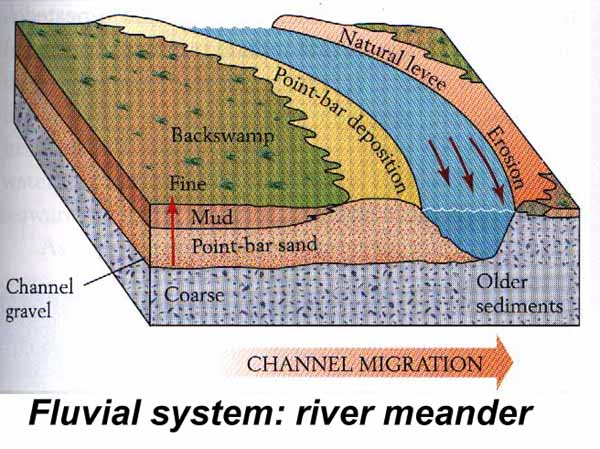
Let's put it this way: If you have silt along the Nile then that's its depositional environment, no problem. Now I don't offhand recall where I read it (or if it made it into this topic), so I'm going to commit the crime of not having a reference. But when Walther was formulating his law, he was looking at river sediments. Even in the river environment, there are sub-environments. The most prominent different sub-environments are channel deposits vs. point bar deposits vs. floodplain deposits. At any given time the flood plain is lateral to the channel. When the river channel meanders, you then get floodplain sediments on top of point bar deposits on top of channel deposits. Or if the entire river basin is building up, then you might get the opposite vertical sequence. Something along this line:
Source In the above, no channel deposits are shown, but you can see both vertical and lateral point bar/floodplain sequences. Critiques of the message are welcome. Perhaps someone else can present this better. All in all, I think you can visualize Walther's Law easier in marine transgressions. Moose Edited by Minnemooseus, : Typos, or something like that.
|
|||||||||||||||||||||||||||||||||||||||||||
|
Minnemooseus Member Posts: 3945 From: Duluth, Minnesota, U.S. (West end of Lake Superior) Joined: Member Rating: 10.0 |
Percy writes: edge writes: I think you would find that it's all a bit more complex than that. I find it odd that you have accepted Walther's Law, but now reject stacked environments. Well, yes, precisely, there's that contradiction, but Faith doesn't understand Walther's Law. She still thinks that a flood's incursion onto land deposits sedimentary layers following Walther's Law. You're saying the "The Flood" deposition wouldn't follow Walther's Law??? Am I agreeing with Faith and disagreeing with Percy? Moose Edited by Minnemooseus, : Two sentences, and I still had a typo.
|
|||||||||||||||||||||||||||||||||||||||||||
|
Minnemooseus Member Posts: 3945 From: Duluth, Minnesota, U.S. (West end of Lake Superior) Joined: Member Rating: 10.0
|
Percy writes: Another aspect of Walther's Law is that long time periods are required to produce the sand, mud, silt, clay and limestone sediments that comprise the majority of sedimentary layers. It's not so much that Walther's Law requires long time periods. It's more a matter that big picture geological reality requires long periods of time. "The Flood" is dis-reality. Looking at the "if the Biblical story was true perspective", the Earth's pre-Flood geological nature is an unknown. But let us suppose a Biblical type flood started tomorrow. What would happen? I'll give you my image of what "The Flood" results would look like, and then give a link to an old topic that went into this subject.
End result - A land surface that is largely barren rock. Deep river valleys and huge deltas with sediments ranging from huge boulders to fine clay (arranged per Walther's Law). Nothing like what we see today. Now, the old topic - Big-Sediment vs. Little-Sediment Flood Geology? (2003). Started by lpetrich, 2nd and 4th messages by roxrkool, 6th message by Minnemooseus (more or less saying what I said above), and beyond. MooseProfessor, geology, Whatsamatta U Evolution - Changes in the environment, caused by the interactions of the components of the environment. "Do not meddle in the affairs of cats, for they are subtle and will piss on your computer." - Bruce Graham "The modern conservative is engaged in one of man's oldest exercises in moral philosophy; that is, the search for a superior moral justification for selfishness." - John Kenneth Galbraith "Yesterday on Fox News, commentator Glenn Beck said that he believes President Obama is a racist. To be fair, every time you watch Glenn Beck, it does get a little easier to hate white people." - Conan O'Brien "I know a little about a lot of things, and a lot about a few things, but I'm highly ignorant about everything." - Moose
|
|||||||||||||||||||||||||||||||||||||||||||
|
Minnemooseus Member Posts: 3945 From: Duluth, Minnesota, U.S. (West end of Lake Superior) Joined: Member Rating: 10.0 |
Your first bullet is pretty much mine too, the rain eroding the land down to solid rock, sediments as you say heading to lower elevations. I called that solid rock "bedrock" which started some kind of fuss with edge which never made any sense. I see on that old thread that roxrkool called it bedrock too. I guess it's only if I use a word that there's a problem. I haven’t researched it, but to me bedrock is more of an engineering term, something solid enough to build something heavy on. A term you hear more in geology is basement rock":
quote: Edge and roxrkool are experienced working geologist. I’m a much less experienced, not working geologist.
But I don't see the huge rivers you see. More likely thousands of small rivers or rivulets flowing off hills in a sea of mud that slides down in masses and sheets. So I don't see the delta buildup you see, or the formation of river valleys. I didn’t mention the upstream flow, but that is what would get the sediment down to the large rivers. It is really speculation, of what the water/sediment load ratio would be. I was visualizing more towards the water carrying a lot of sediment, but I’m sure that in at least some situations it would be flat out mud flow. Either would get the sediment moving down gradient, but I see the less dense and viscous flow as moving all the sediment better. The denser and viscous mud flow would leave more lag deposits behind, especially in lower gradient (less steep) areas. In other words, where things got less steep, the mud would pile up. But while the solids would stop, some of the water would continue moving. And remember, it’s raining really hard everywhere, so more water is always being added.
Soon rising sea and soaked sediments meet and mingle in a thick soup over the denuded bedrock. This is the ocean so we have tides and waves and currents to move things around. Now you’re (more or less) talking waves reworking a mass of sediments with grain sizes ranging from clay to boulders. The boulders would stay in place, and the finer sediments would disperse, the gravels close, the sand further away, the silt further away, and the clays even further away. You’d have the distribution shown in the various Walther’s Law diagrams that have been posted. But you’re not going to get limestone, which is of biogenic origin.
Here's where I figure Walther's Law might enter, as the water is rising over the land, starting the process of building up strata on the naked bedrock according to those sorting principles. That process could start later though, not sure what all has to be taken into account. Basically correct. But Walther’s Law isn’t really that of a sorting process. It’s a geometric description of what you get when depositional environments shift. Which I guess is sort of splitting hairs.
One way or the other the sediments are redeposited on the land mass in layers by the end of the Flood Three miles deep at least. So when the water recedes and erodes some of it away there's so much of it, and it's already so compacted in the lower layers, the erosion is far from scouring it down to bedrock again. But I think that the reworks sediments would form a relatively thin veneer on top of a much thicker heterogeneous clay/silt/sand/gravel/boulder horizon. And we don’t have enough sediment available to be eroded (my the way things are today scenario) to form widespread miles thick layers. Besides, you’d only get a single transgressive/regressive sequence, not the multiple that we can see in the geologic records (geologic column). And you wouldn’t get limestones or other biogenic deposits. And there’s always the problem of all the deposits that are not of marine origin, mixed in there in your geologic column.
Since you don't believe in the Flood you don't have to make it fit what we see today, you can just pronounce it impossible and forget about it. We just created a what the results of the flood would be scenario. And it doesn’t match up with what we actually see. This is part of why we say The Flood never happened.
But obviously I can't stop where you stop. And besides I think my scenario is more feasible than yours. You are not troubled by the fact that your feasibility scenario totally clashes with those of people who have done a lot of schooling and field work, studying geologic processes and their results? That’s kind of like if I (geologist) went a told a renowned brain surgeon that he didn’t know what he was doing.
No way to test it, is there? A lot of processes can be seen out in the field, and be modeled in the lab, even if we can’t perform an experiment on the world wide scale. Moose ps - To the real geologists - Feel free to correct me where I went wrong.
|
|||||||||||||||||||||||||||||||||||||||||||
|
Minnemooseus Member Posts: 3945 From: Duluth, Minnesota, U.S. (West end of Lake Superior) Joined: Member Rating: 10.0
|
Thinking more about Walther's Law, not clear how the sediments deposit. As the water rises onto the land are the sediments precipitating out or what? Mud, silt, and sand are clastic sediments. They are fragments of pre-existing rocks. They are sorted because the coarser clasts settle out faster/closer to land, and the finer clasts get further from land. That's the short version. Limestones (carbonates) and foram oozes are of biogenic origin. The forams settle out of the water above, while the limestone is created more in place. Much of the limestone "critter product" is reworked by further biogenic actions ("critters chewing on other critter's shells"). Limestone come in a number a varieties, which I'm not going to get into here. That's also the short version. Part of the reason you get limestone, is because the clastic sediments are not making it out that far from shore.
Also it seems they are all being deposited at the same time in their respective locations -- sand, mud, silt, carbonates, foram ooze -- rather than sequentially. At least the horizontal sequence is. Is this correct? Correct. All are being deposited on the sea floor of the time. That Walther's Law diagram just up-thread is a good thing to look at closely. But remember, it is a diagram, an approximate illustration of reality. Reality is that the contacts between the different rock types are probably more gradational, both laterally and vertically. Also be aware that in geologic cross section diagrams, there is often an exaggeration in the vertical scale. What is shown as sloping is probably actually quite close to horizontal in the real world. This vertical exaggeration also makes things thicker than reality. This is done to enable showing feature detail that would be otherwise lost. Moose
|
|||||||||||||||||||||||||||||||||||||||||||
|
Minnemooseus Member Posts: 3945 From: Duluth, Minnesota, U.S. (West end of Lake Superior) Joined: Member Rating: 10.0
|
I know that Edge replied twice to this message and that there has been a further chain of messages after that. But I'll reply independent of that, even if Edge has already said some of what I'm about to say.
OK, though I have a feeling if I used "basement rock" he'd object to that too, even if it's correct. I think I'll go with your original "solid rock." That's probably not safe either but at least it doesn't suggest something technical. I think that both "basement rock" and "solid rock" can be nebulous terms. Kind of a "compared to what" thing. And while "basement rock" is probably also pretty "solid rock", a lot of above the "basement rock" can also be pretty solid.
I just don't see big rivers BECAUSE it's going on raining very hard everywhere, not just in the higher areas, and it's all running off the higher areas willy-nilly, most of it mudslides. I suppose small streams would run into big streams here and there but I can't see anything that organized remaining for long BECAUSE it keeps going on raining everywhere and breaking up everything, any river banks trying to form would be eroded away in the overflow before they could even get formed. It's all speculation though. I'm a bit boggled about how to reply to this. The amount of flow in any drainage will get a lot larger, and the valleys of all the streams and rivers will get a lot larger. A real world example is the Minnesota River valley. Now it is a pretty big valley containing a relatively small river. Why? Because of the large flow drainage of Glacial Lake Agassiz. Kind of like the channeled scablands from Glacial Lake Missoula, but in a different geological ("bedrock") context.
OK to most of that but not sure why not limestone. If it's deposited anywhere according to the Walther's model, being present in the sea water, it should be present in THIS sea water too and deposit in its turn along with all the other sediments. As I discussed in Message 889, Walther originally formulated his law from studying the sedimentation patterns of meandering rivers (another migrating environment). No limestone there. We've largely looked at transgressing sea models because Walter's Law is easier to understand in that context. A transgressive/regressive sea model is also much more relevant to "The Flood". Anyway, to the reason for lots of clastic sediments but no limestones. It is conceivable to transport a lot of clastic material in, and then dump it at a location. But limestones (with very minor exceptions) are derived from the remains of animal hard parts (clam shells, coral, etc, etc). It is grown in place, not brought in as clastic material from elsewhere. And it takes a considerable amount of time to grow enough critters to form any thickness of limestone. So, at most, limestone deposition will be very minimal. Especially since animals won't be surviving very well in the turbid waters of your "Flood".
Afraid "sorting process" is clearer to me than "what you get when depositional environments shift" though I'd be happy to use that description if I could understand it. Anyway, thanks for being a big enough guy to say that Faith could ever get anything "basically correct." Sorting processes happen in a given environment and sub-environments (all environments are part of a larger environment). In our seashore model we have the seashore environment, with the onshore, near shore, and further and further offshore sub-environments. As long as this environment is stable at a given location, you get the same variety of sediment at each sub-environment. But if the environment shifts in a sea transgression, then the sand, silt, clay, limestone, and whatever etc. deposition locations also shift. Thus you can end up with and see, in a vertical column, limestone on top of shale (clay), on top of siltstone, on top of sandstone. The bottom to top sequence is the same as the shoreline to deep water sequence. That is Walther's Law. For deposition from a receding (regressive) sea (environmental shift in the opposite direction), the vertical sequence would be the opposite (Sandstone on top, limestone on the bottom). But that still relates to Walther's Law. Now "in theory", what we should see is a regressive sequence (the sea has gone out) on top of a transgressive sequence. But it is my understanding that regressive deposits tend to be poorly preserved. This is because what had been a depositional environment becomes an erosional environment. Who knows, maybe the erosional environment would also wipe out what had been the transgressive deposits.
Anyway, thanks for being a big enough guy to say that Faith could ever get anything "basically correct." I said "...basically correct. But...". That could have been "...essentially correct. But..." or "...correct. But...". It all means the same - There's that "But".
Minnemooseus writes: But I think that the reworks sediments would form a relatively thin veneer on top of a much thicker heterogeneous clay/silt/sand/gravel/boulder horizon. This I don't get. If the sea water creates layers then it should layer all this too. This was speculation on my part, and I don't really feel up to going further into it now. But if indeed all the deltaic deposits were indeed reworked by the sea transgression/regression, what we would see is some variation of a single transgressive/regressive package. Which we don't.
But the way things are today IS that we have extremely thick deposits of strata in many places and the clear indication that those existed in other places too but were eroded down to much less. Some of the strata span entire continents in very thick slabs. I don't get what you mean about not having enough. And we don't know how much sediment made up the original land mass, all we can do is extrapolate from what we have now anyway. If a depth of three miles of strata were originally laid down on the rock base of the continents, and a great deal of that washed into the sea, that should be enough sediment for my scenario. We are exploring the "what if "The Flood" happened starting tomorrow" scenario. How much of that sediment pile would have eroded is a big question. Besides, remember that the bulk of all that sediment is below the current sea level and thus wouldn't be eroded. And if we take the current state of affairs as being the "pre-Flood" "geologic column", it raises the question "how did all that pre-Flood sediment get deposited?" Which maybe brings up a whole "maybe worthy of it's own topic" question - What was the YEC pre-Flood "geologic column". Minnemooseus writes: Besides, you’d only get a single transgressive/regressive sequence, not the multiple that we can see in the geologic records (geologic column). OK. That's something ponder. If the multiple is correctly interpreted. Ponder away, oh mighty one.  If you are willing to buy into Walther's Law, then multiple is the interpretation. If you are willing to buy into Walther's Law, then multiple is the interpretation.
Again I don't get why not limestone since it normally gets laid down as part of the Walther's sequence simply because it's in the oceans. ... I think I covered this above.
And you all created this same sort of scenario on that old thread you linked too, which was fun to read because it's all exactly the same sort of speculation creationists do, though of course we're going to speculate in the direction of explaining "what we actually see" by it and you aren't. Your speculations don't match up with what we actually see, but creationists' do. As long as it's all speculation, which it is, I don't see that yours have a better claim than ours. Boggled.
I'd be a lot more troubled by any scenario that clashes with what God has revealed than anything that clashes with what mere human beings come up with, no matter how educated or sincere. Well, there are two versions of the creation story. One is the print of the Bible and the other can be seen by looking at the creation itself (the worldly evidence). I think the creation itself has a lot more information, and it doesn't agree with your Bible version. Or something like that. Moose Edited by Minnemooseus, : "No" into "Now". I was too fried to do a final proofread when I posted this. Probably missed something else also.
|
|||||||||||||||||||||||||||||||||||||||||||
|
Minnemooseus Member Posts: 3945 From: Duluth, Minnesota, U.S. (West end of Lake Superior) Joined: Member Rating: 10.0 |
Oh, but I can answer now that God's written word is a lot more articulate than His natural world for which we have only our own reasoning in order to "read" it. That's why He had to give us the written word. There are not "two versions" of the Creation story, there is only one, the problem is we read the rocks wrong. If by "articulate" you mean "Saying relatively little in a clear concise way"* vs. "Leaving a prodigious amount of challengingly complex evidence", then yes, the written word is more articulate. Wrong, but articulate.
{Even I can't completely hold off doing the snark.} I just had to express that much. Will come back to try to deal with the rest of your post. Likewise. No reply needed. Actually, I hope for no reply. Moose
*Although there is that "What exactly are the fountains of the deep" question. "Gopher wood" isn't an issue for me.
|
|||||||||||||||||||||||||||||||||||||||||||
|
Minnemooseus Member Posts: 3945 From: Duluth, Minnesota, U.S. (West end of Lake Superior) Joined: Member Rating: 10.0
|
I have to jump on this one.
Well, show me where it is depositing on top of the Holocene somewhere. quote: The Holocene end is the present. Right now, the division between the past and the future. As time passes, we are always getting a new right now. The recent end of the geologic time scale ("geologic column"} is the most recent end of the Holocene (aka "NOW"). New sediments are not being added ON top of the Holocene (as in, there is no more recent geologic time period). New sediments are being added TO the Holocene, or to be more precise, added to whatever is the current geologic material surface. Anything that now happens, happens during the Holocene.
The Holocene is a period of time. Things geologic (including sedimentation) has happened and will continue happening during the Holocene. Now geologist do refer to sedimention etc. that happened during the Holocene time period as being "the Holocene". But that use of "the Holocene" is just a shorthand way of saying "happened in the Holocene time period". I guess you could call that misuse of the term to be "geologist slang". But be it in the context of geologic time, or in the context of geologic materials, geologist know and understand the meaning of the "geologist slang". One last time - The Holocene is a time period. In geo-slang usage it is also materials of that time period. But in strict usage of the term, "the Holocene" does not refer to any physical material. Likewise, in the bigger picture, the geologic time scale does not refer to any physical material. Especially in casual use, geologists may use the term "geologic column" as being synonymous to "geologic time scale". Or they may using "geologic column" to refer to A SPECIFIC rock column (stratagraphic section). And depending on the context, they know which is which. There is only one geologic time scale (aka "geologic column"). But there are an infinite number of specific rock columns/stratagraphic sections (also aka "geologic columns"). To be absolutely clear, when talking about geologic time, use the term "geologic time scale". When talking about a pile of rocks, use the term "geologic section" or "the geology of the location". Thus ends the sermon, and instead of "amen", I must say, "or something like that". Further questions welcome. Moose
|
|||||||||||||||||||||||||||||||||||||||||||
|
Minnemooseus Member Posts: 3945 From: Duluth, Minnesota, U.S. (West end of Lake Superior) Joined: Member Rating: 10.0 |
You're right. What that means is there won't be a time period after the Holocene reflected as part of the Geologic Column because it DOES have to be represented by a layer on top of the Holocene. The Holocene is a time period, just like seconds, minutes, hours, days, weeks, months, years, and centuries, only a lot longer and not having a pre-determined ending. Imagine that we were having this conversation during what turned out to be the final part of the Pleistocene. Then you would be saying "There won't be a time period after the Pleistocene reflected as part of the Geologic Column because it DOES have to be represented by a layer on top of the Pleistocene." Yet the Holocene happened, and eventually there will be an epoch that happens after the Holocene. We won't live to see it. Maybe humanity won't live to see it, as its beginning may be defined by the human extinction. And sedimentation etc. will go on, as part of the postHolocene "geologic column". Anyway, what exactly to YOU mean by the term "geologic column"? Is it "geologic time scale" or is it "stratagraphic section"? Are you talking the sum of the time periods of the Earth's history, or are you talking about the rocks? Moose
|
|||||||||||||||||||||||||||||||||||||||||||
|
Minnemooseus Member Posts: 3945 From: Duluth, Minnesota, U.S. (West end of Lake Superior) Joined: Member Rating: 10.0 |
Edge writes: Faith writes: But we aren't in the Pleistocene and there won't be anything after the Holocene. Well, this is 2014 and there won't be anything after that. I thought about using that sort of analogy, but 2014 has a now defined (known) end and the Holocene does not. But a now unknown does not mean it's never going to end. Faith seems to be operating under some variation of the Holocene having being defined as having ended, or maybe it's "the Holocene is never going to end". I'm not sure which. At least she seems to have defined her interpretation of "geologic column" as being a stratagraphic sequence (aka "the rocks"):
Faith, in message 1097, writes: I'm too used to "Geologic Column" to change to "geologic section" or "the geology of the location". Don't see why there should be a problem. It refers to the physical strata. Faith, in message 1098, writes: Minnemooseus writes: Anyway, what exactly to YOU mean by the term "geologic column"? Is it "geologic time scale" or is it "stratagraphic section"? Are you talking the sum of the time periods of the Earth's history, or are you talking about the rocks? It's the rocks, always the rocks, only the rocks. Specifically the strata on which the Geologic Time Scale was constructed. I guess now we need to expound on how the geologic time scale was constructed. I think she has some sort of mixture or right and wrong in the quote right above this paragraph. Moose Edited by Minnemooseus, : Change subtitle.
|
|||||||||||||||||||||||||||||||||||||||||||
|
|
Do Nothing Button
Copyright 2001-2023 by EvC Forum, All Rights Reserved
![]() ™ Version 4.2
™ Version 4.2
Innovative software from Qwixotic © 2024


 (1)
(1)